Easing S'ly swell with a great N/NE swell for the weekend

Eastern Tasmania Surf Forecast by Craig Brokensha (issued Monday 1st April)
Best Days: South magnets tomorrow morning, Saturday
Recap
Fun clean 2-3ft sets out of the N/NE on Saturday, fading overnight to be replaced by a small and acute S'ly swell Sunday.
Our better aligned and more reliable S'ly swell for today has come in on forecast with clean fun 3ft sets on the regional south magnets.
Today’s Forecaster Notes are brought to you by Rip Curl
Tomorrow through next week (Apr 2 - 7)
Today's S'ly groundswell was generated by a good polar fetch of strong to gale-force S/SW winds over the weekend, and there should still be fun sized sets on offer tomorrow, easing through the day and tiny Wednesday.
South swell magnets are due to ease from 2-3ft with a great N/NW tending NW offshore.
Come Wednesday there may be a tiny hint of N/NE swell in the water but we've got a more reliable though windy E'ly tending E/NE and then NE swell due to develop later week and into Saturday.
 The swell will develop as a small strong high moves in from the west, squeezed slightly on its northern flank resulting in a fetch of strong E/SE tending E/NE winds to be aimed through our swell window.
Only a weak windswelly increase in size is expected on Thursday afternoon and more so Friday to 2-3ft across open beaches and with onshore E tending NE winds.
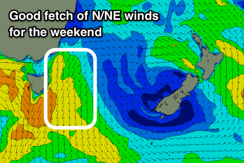
Into the end of the week though a strong front moving in from the west will squeeze the high, with a great fetch of strong N/NE winds due to develop down the coast Friday evening and early Saturday morning.
This should see the swell build rapidly from the NE and peaking during the day Saturday to 3-4ft across north-east magnets with a N/NE tending N/NW and W/NW breeze later.
Sunday will be clean again with NW offshores but no leftover size above 1ft to maybe 2ft.
Therefore try and plan around a surf Saturday afternoon.