Fun waves to finish off the week, distant groundswell a chance next week

Eastern Tasmania Surf Forecast by Craig Brokensha (issued Wednesday 6th February)
Best Days: Northern corners Thursday, Friday morning
Recap
Average surf yesterday but today a new E/NE swell is on the build, and while onshore it's still looking fun on the open beaches.
Today’s Forecaster Notes are brought to you by Rip Curl
This week and weekend (Feb 7 - 10)
Our current increase in E/NE swell is due to a good fetch of relatively weak E'ly winds setting up through the Tasman Sea to our east-northeast.
This fetch will start to swing more towards us during this afternoon and evening as a trough across South Australia edges in from the west, with winds swinging NE-N/NE into tomorrow before moving away from us Friday.
 What this will result in is a peak in E/NE swell through tomorrow to 3-4ft across open beaches but with fresh NE winds, tending more N'ly early afternoon and then N/NW late in the day.
Friday is still looking clean with a NW offshore, possibly tending variable ahead of a late S'ly change. The swell will be easing out of the E/NE and NE from 2-3ft, tiny into the weekend.
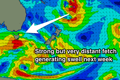
Into early next week there's nothing too significant on the cards, but a very distant though significant tropical development south of Fiji will see a fetch of E/NE gales generated in our swell window.
A very inconsistent long-range E/NE groundswell should be generated, arriving Tuesday and building to 2ft, with a possible peak to 2-3ft on Wednesday. We'll have a closer look at this on Friday when we should be more certain on the fetch aimed through our swell window.