Fun E'ly swell with improving winds

Eastern Tasmania Surf Forecast by Craig Brokensha (issued Wednesday 22nd March)
Best Days: Southern corners early tomorrow, Friday morning, Saturday morning, Tuesday
Recap
Not the best conditions yesterday with a small easing NE windswell, while today some new SE tending E/SE swell is on the build but with poor winds.
This week and weekend (Mar 23 - 26)
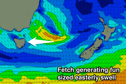
The small low sitting to our east-northeast is starting to take shape and we should see some more noticeable size later today from an infeed of E/SE winds across its southern flank.
The low will slow move east while maintaining a fetch of strong E/SE-SE winds through our eastern swell window.
The low is looking a touch weaker than Monday but we should still see fun levels of E'ly swell from tomorrow through the weekend.
 Open beaches should see surf to 3ft tomorrow, similar through Friday and Saturday morning ahead of a noticeable easing trend.
Come Sunday fading 1-2ft sets are due.
We should see one final pulse of small E'ly groundswell Tuesday as the low deepens over New Zealand Saturday evening and Sunday, aiming a small fetch of E'ly gales towards us.
This pulse though isn't expected to top an inconsistent 2ft.
Coming back to the local winds, and tomorrow S/SE tending SE winds will leave protected southern corners with the best conditions, while an early SW offshore is due Friday morning, NW Saturday morning.
Some small NE windswell should be seen into Sunday from a slight fetch of NE winds aimed into us through the evening and Sunday morning, but only to 1-2ft or so.
Unfortunately our bigger NE swell event for Monday has been downgraded with no major size due at all. We'll have another look at this Friday though.