Solid NE swell for tomorrow

Eastern Tasmania Surf Forecast by Craig Brokensha (issued Wednesday 15th March)
Best Days: Thursday as winds start swinging offshore, Friday morning southern corners, Sunday through Tuesday mornings
Recap
Small waves the last few days as we fall in between swells. We should see the surf increasing out of the NE later today but with gusty N/NE winds.
This week and weekend (Mar 16 - 19)
During this afternoon/evening and early tomorrow, a broadening and strengthening fetch of NE winds will develop through our north-east swell window as an approaching front from the west squeezes a high in the Tasman Sea.
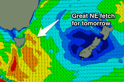 We should see the NE swell really pick up into tomorrow morning, coming in at 4-5ft across north-east facing beaches.
The front will move through during the day, swinging winds from the N/NW through the morning to the W/NW mid-late afternoon. Therefore a late surf is probably the best but expect smaller size by then.
A S'ly change during the evening will leave S/SW winds into Friday morning, swinging E/SE into the afternoon along with easing levels of NE swell from 3ft.
Into the weekend and early next week the NE swell isn't expected to drop below 2ft to occasionally 3ft as a persistent weak fetch of E/NE-NE winds sit through the central Tasman Sea in our swell window.
This fetch will weaken a little and swing more E away from us from Sunday evening, and this will result in the NE swell dropping from Tuesday.
Winds on Saturday will remain average and from the NE, but Sunday and Monday should see morning offshores.
Longer term we may see a small low forming off our coast later next week, generating some E'ly swell, but more on this Friday.