Plenty of NE swell for the period

Eastern Tasmania Surf Forecast by Craig Brokensha (issued Monday 13th March)
Best Days: Thursday when winds start swinging offshore
Recap
Great surf all weekend with moderate to large amounts of E'ly swell with good winds each morning.
Today the surf has finally backed off to a smaller 2ft with light offshore winds.
This week and weekend (Mar 14 - 19)
There won't be much downtime between swell events, and that's the way we like it!
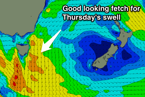
We're currently seeing a strong high moving into and establishing itself in the Tasman Sea, and we'll see this high squeezed both on its northern and western flanks.
This should produce a strengthening and broad fetch of NE winds down the East Coast, tending more E'ly towards New Zealand.
 Building levels of NE windswell will be seen, with some smaller background E/NE energy arriving a little behind it from later tomorrow but more so Wednesday.
Tomorrow is expected to be around 1-2ft with variable tending N/NE winds.
A slow increase in NE windswell is then due Wednesday from 2-3ft, a touch more consistent in the afternoon, with the biggest increase Thursday as winds really kick up overnight.
North-east facing beaches should see 3-5ft sets, 3ft across most other spots and conditions should improve as a N/NW tending W/NW change moves through.
This will bring S/SE tending E'ly winds into Friday with smaller amounts of NE swell to 2-3ft.
A new ridge of high pressure is due to build in the wake of Thursday's front and with this we should see the NE swell increasing again from the weekend, but probably not to Thursday's size.
We'll have another look at this Wednesday though.