Great easing E'ly swell, NE windswell later next week

Eastern Tasmania Surf Forecast by Craig Brokensha (issued Friday 10th March)
Best Days: Saturday morning, Sunday morning, Monday morning protected spots, Friday
Recap
Good clean waves around 3ft yesterday morning, easing through the day, while today a strong new pulse of E'ly groundswell was visible around dawn with 3-4ft+ sets, strengthening further during this afternoon.
This swell should be peaking across the coast this afternoon/evening and will tail off slowly over the weekend. More on this below.
This weekend and next week (Mar 11 - 17)
The Tasman Low and fetch of E'ly gales responsible for today's large building E'ly groundswell weakened yesterday but we're still seeing a great fetch of strong E'ly winds being aimed through our eastern swell window.
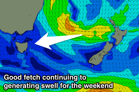 The low is expected to continue weaken while tracking slowly south-east across New Zealand, aiming a good fetch of SE winds through our swell window tomorrow, gone by Sunday.
With this we should still see large sets tomorrow morning at open beaches, coming in at 4-6ft, easing slowly, further down from 3-4ft Sunday morning.
Some small E/SE swell is then due from the SE fetch Monday, continuing around 2ft+.
Winds tomorrow morning should be variable and light offshore before sea breezes kick in, similar Sunday but with a freshening E/NE'ly through the afternoon.
A weak low off our coast on Monday will see S/SW tending S/SE winds along with a small NE windswell.
This low is expected to dissolve through early next week, but a strong building high pressure ridge through the Tasman Sea should produce a strengthening fetch of NE winds through our north-eastern swell window late week.
With this building levels of NE windswell are due but with N/NE winds before a W'ly change possibly moves through Friday. We'll check the timing of this change on Monday though. Have a great weekend and enjoy the swell!