Workable mix of swells on Tuesday, not much following

Eastern Tasmania Surf Forecast by Guy Dixon (issued Monday 20th)
Best Days: Tuesday and Saturday
Recap:
Small options were on offer over the weekend, generally background energy filling in out of the south with only Sunday morning offering an opportunity for a very small but clean wave. Today, open beaches have seen a small increase in size out of the east/northeast, with peaks in the 1-2ft range under a southerly breeze.
This week (Tuesday 21st - Friday 24th):
We are in for a dynamic day on Tuesday as more the east/northeasterly swell fills in. Options should build to around 2ft+ across open beaches, before diminishing fairly rapidly due to the worsening alignment of the main northeasterly in feed.
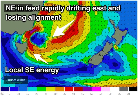 Also in the mix however will be a rapidly building southeasterly local swell generated along the southern flank of a low that is deepening and shifting south as we speak.
Gusty southeasterly winds should increase late this evening, tending southwesterly into Tuesday. South facing beaches should build to around 5-6ft by Tuesday morning, dropping fairly rapidly as breezes quickly tend southwesterly and eventually due westerly.
Conditions should be fairly workable, swinging from southwesterly through to west/northwesterly as the day progresses.
Left over east/northeasterly and south-easterly energy will become small on Wednesday across open beaches, fading from 2ft, although if this is your last opportunity to surf, take it. Winds should persist from the west/northwest throughout the day.
Following this, frontal activity looks to continue, although the zonal nature doesn’t bode well for swell generation along the eastern shores of Tasmania. Only the southern extension of a modest southwesterly fetch on Wednesday evening have the potential to add a small amount of southerly energy for the late week, but even then it looks negligible.
The only plus side will be persistent northwesterly winds only swinging southwesterly late on Friday.
This weekend (Saturday 25th - Sunday 26th):
Leading into the weekend a strong cold front looks to cut off as it squeezes through Bass Strait, steering a small but intense southerly fetch up towards NSW.
Unfortunately, the southern most extensions of the fetches circulating this system are on an equal latitude to Tasmania, so any decent swell will likely be limited. A local southerly fetch are expected hug the coast on Friday night, adding around 2ft of ordinary short range southerly energy to the mix for Saturday morning, easing thereafter.
Fortunately, we should be able to take full advantage of this small swell as westerly breezes tend northwesterly throughout the weekend.
Next week (Monday 27th onward):
We will likely have to wait until early next week until any decent east/southeasterly energy fills in off the backside of this low. Southeasterly fetches along the southern quadrants of this system should provide better energy for early next week, not to mention a bonus east/southeasterly pulse generated from fetches off the West coast of NZ.
More detail on Wednesday.