Tiny NE windswells, possible E/NE trade-swell next week

Eastern Tasmania Surf Forecast by Guy Dixon (issued Wednesday 27th April)
Best Days: No great days, hopefully next week.
Recap:
It’s been a quiet few days in the swell department, with barely a wave breaking on Tuesday and just a weak shorey today. On the plus side, persistent northwesterly breezes have kept conditions clean.
This week (Thursday 28th - Friday 29th) and this weekend (Saturday 30th - Sunday 1st):
A northerly fetch has been increasing throughout today ahead of an approaching cold front, although the intensity and alignment into the coast is nothing over exciting.
A small northerly windswell should increase to a peak on Thursday morning to around 1-2ft across the open beaches, remaining generally clean and workable on a board with plenty of volume under a northwesterly airflow.
The front itself however doesn’t look to provide any decent swell for eastern Tasmania however as a stubborn Tasman ridge deflects it to the south. Westerly core fetches are fairly intense, but the storm track and alignment of winds aren’t likely to provide anything worth considering.
A second small northeasterly swell looks to fill in on Saturday, although very modest with only 1ft or so breaking across northeast facing beaches generated by a brief and weak fetch off the NSW coast.
Northwesterly breezes look to persist leading to clean conditions, although gusty, potentially ironing out the small amount of swell in the water.
Next week (Monday 2nd onward):
Better prospects of surf are on the cards next week as easterly trade energy increases.
For those who have missed it, a stationary southeasterly fetch steered by the northern flanks of this Tasman ridge has been providing a hell of a lot of surf for northern NSW and southeast QLD for the past few days.
This southeasterly flow is due to broaden and rotate in the next few days, but persisting and being reinforced by another broad trade fetch located further east.
Open beaches should begin to see small hints of east/northeasterly energy in the 1ft range early next week, with the possibility of more size late week and into the weekend.
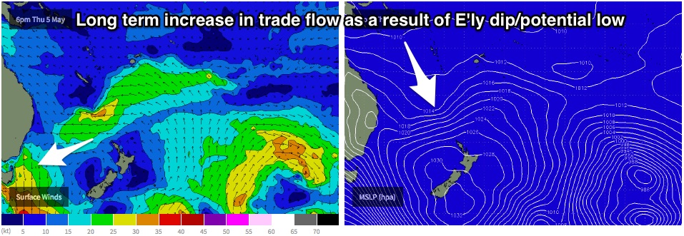
The latest model runs have been suggesting the development of a pair of dips/lows over the northern Tasman, lead to an increase in an increase in the easterly trade flow. By next weekend, open beaches have the potential to be picking up peaks in the 2-3ft range, however at this stage, the scenario looks dynamic, with limited confidence.