Clean easing E'ly swell tomorrow, onshore SE swell for mid-next week

Eastern Tasmania Surf Forecast by Craig Brokensha (issued Friday 11th March)
Best Days: Saturday morning, Thursday morning, Friday morning
Recap
Nothing too significant yesterday with a small weak S'ly swell, while today building levels of E/NE swell are being generated, but with onshore winds.
This weekend and next week (Mar 12 - 16)
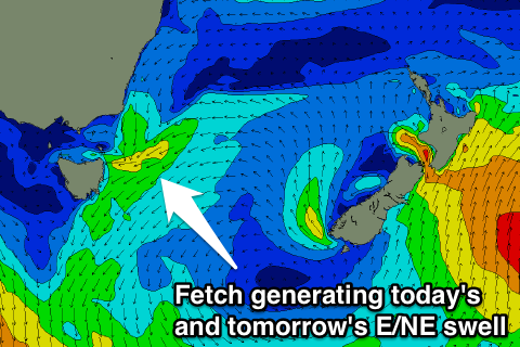 A small surface trough is currently deepening off our coast, directing a fetch of strengthening E/NE winds through our eastern swell window.
This is producing today's building E/NE swell, with the trough due to drift south-east through this afternoon and evening, cutting off the infeed of E/NE winds through our swell window. A drop in swell is expected from 2-3ft at dawn, quickly back to 1-2ft into the afternoon.
Conditions look great with a light morning offshore wind ahead of a shallow S/SE change through the day.
Into next week we've got plenty of S/SE tending E/SE swell on the cards. A S'ly change moving through Monday will be linked to a building ridge of high pressure in from the west, while an inland surface trough across Victoria will squeeze the ridge, directing a sustained fetch of strong SE winds into our East Coast through most of next week.
An initial increase in poor quality and small S/SE windswell is due Monday afternoon from a fresh S/SE change, with a broader SE fetch developing through Tuesday, tending more E/SE into Wednesday before then breaking down through Thursday.
Open beaches should build to 3ft through Tuesday but with poor onshore S/SE tending E/SE winds, muscling up to 3-4ft Wednesday as E/SE winds persist, easing back from 3-4ft Thursday as lighter winds develop. By the time winds swing true offshore Friday only small easing 2ft sets are due.
We'll have a closer look at this Monday though. Have a great weekend!