Great weekend, largest Sunday morning

Eastern Tasmania Forecast by Craig Brokensha (issued Friday 26th February)
Best Days: Saturday, Sunday, early Monday for keen surfers with the light onshore, Wednesday morning
Recap
A good fun mix of long-range E/NE groundswell and NE windswell yesterday with morning offshores, while today the swell's back to a smaller 2ft as we fall in between pulses.
This weekend and next week (Feb 27 – Mar 4)
What we'e expecting over the coming weekend is a couple of different pulses of E/NE groundswell, the first the least consistent and smallest, becoming larger and more consistent towards a peak Sunday morning.
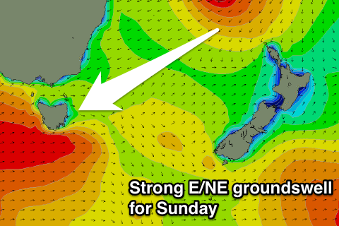 The first pulse tomorrow will be from when Tropical Cyclone Winston moved out of New Caledonia's swell window, drifting south towards us.
This should see open beaches picking up inconsistent 2-3ft sets through the morning, growing to a stronger 4ft later in the day.
Sunday is the day though, as a large long-period E/NE groundswell pushes down from Winston making a west-southwest push towards the Australian East Coast, travelling with the swell it was creating resulting in a captured fetch scenario.
With this we should see open beaches offering strong but inconsistent 4-6ft sets Sunday (with swell magnets likely offering the odd bigger bomb), before easing back steadily from 3-4ft Monday morning.
Conditions are looking good all weekend with W/NW offshores tomorrow ahead of NE sea breezes and then W/NW offshores Sunday morning ahead of an afternoon S'ly change.
Monday is looking dicey with lingering E'ly winds likely, freshening from the NE through the day.
Besides a small pulse of S'ly groundswell for tomorrow, NE windswell will be our main source of surf into Tuesday and Wednesday next week, biggest Wednesday morning to 3ft or so as winds swing offshore.
Beyond this we're looking at nothing too significant but check back here Monday for the latest update. Have a great weekend!