Solid E/NE groundswell peaking on Sunday

Eastern Tasmania Surf Forecast by Guy Dixon (issued Wednesday 24th February)
Best Days: Thursday, Friday and each morning of the weekend.
Recap:
An inconsistent east/northearly groundswell has increased over the past couple of days from the 1-2ft range on Tuesday to the 2-3ft range today. A northwesterly breeze kept conditions nice and clean for the morning session on Tuesday, before deteriorating under a northeasterly seabreeze. Today, that offshore airflow has held out the seabreeze and set the tone for the next few days with nothing but clean options.
This week (Thursday 24th - Friday 26th):
The outlook for swell hasn't changed too much since the last forecast, with east/northeasterly groundswell looking to ebb and pulse between 2-3ft on Thursday and Friday.
The majority of this energy has been generated as a result of the southern flanks of Tropical Cyclone Winston and the adjacent feeder ridge which has been located to the south over the past week or so. Occasional pulses generated by slight intensifications of will lead to lulls and pulses as we’ve seen throughout the past couple of days, with more size due late in the week as the system drifts southwards.
Also in the mix on Thursday will be small hints of a shorter range northeasterly windswell generated by a gusty northeasterly fetch which has been established off the coast of NSW since Tuesday.
The southern extension of this fetch has had poor alignment to the Tasmanian coast for virtually its entire duration, so the impacts of this swell should be particularly underwhelming. Open beaches should only pick up around 1ft of background energy providing small options in between the inconsistent sets.
Conditions look to remain clean at virtually all spots for the end of the week with a west/northwesterly airflow dominating.
This weekend (Saturday 27th - Sunday 28th):
The aforementioned east/northeasterly groundswell is expected to build further on Saturday as a result of the initial southward movement of Winston out from behind the swell shadow of New Caledonia earlier in the week. Open beaches should build to the 3ft range by the afternoon preceding a late kick to the 3-4ft as a period pulse fills in across the coast.
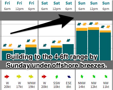 Sunday is expected to yet another kick in size, this time the peak with sets in the 4-6ft range breaking across the open beaches with known swell magnets copping the odd bigger set.
Swells of these size are not a common phenomenon around these parts, with the northeastern swell windows usually just picking up sideband trade energy. However, this system is certainly an exception.
Models have been fairly consistent over the past few days suggesting that Winston should move in a westerly to west/southwesterly direction. The intense swell generating fetches on the southern and eastern quadrants of this system are likely to move in a captured motion, exacerbating the potential for swell production.
In an instance like this, the swell generating fetches move in the same direction as the swell it has already created, working on an active sea-state with compounding results.
Northwesterly breezes should continue for the better part of each morning over the weekend, with a light northeasterly seabreeze developing along the coast around Scamander and Bicheno.
Next week (Monday 29th onward):
All swell sources are due to fade from early next week, with models killing off the chances of that second round of swell.
Residual energy off the back of Winston should ease from the 3-4ft range on Monday morning across the open beaches, further more on Tuesday, dropping from the 2ft range.
By this stage, a ridge should have built overhead, leading to a northeasterly airflow persisting. Surf should fade and conditions should deteriorate so make the most of the weekend.