Solid S'ly swell, with small inconsistent E/NE options

Eastern Tasmania Surf Forecast by Guy Dixon (issued Monday 15th February)
Best Days: Each morning. Thursday looks is worth checking out.
Recap:
We saw the effects of a weak northeasterly windswell over the weekend, with a small swell building to the 1-1.5ft range on Sunday, which faded fairly quickly into today with just 1ft leftover.
Most locations were clean early, before localised seabreezes became established each afternoon, taking the sheen off the quality.
This week (Tuesday 16th - Friday 19th) and (Saturday 20th - Sunday 21st):
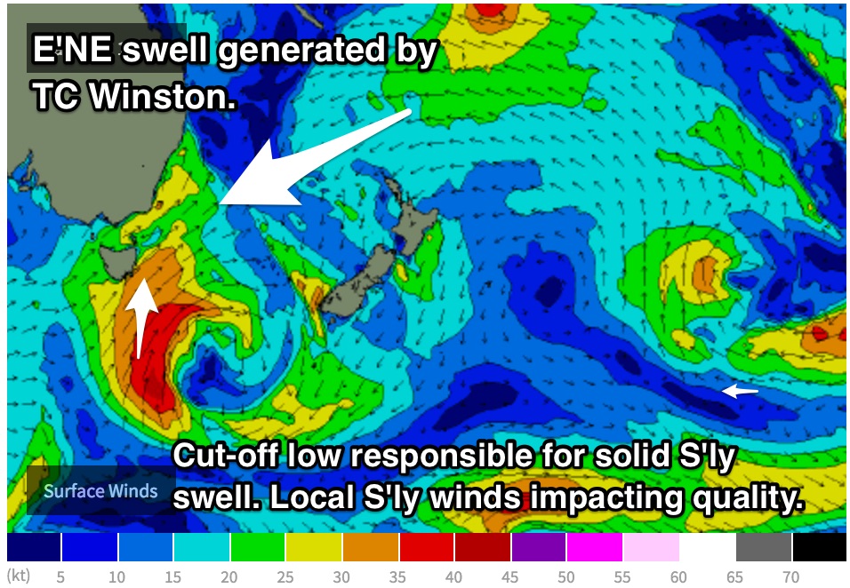
A deep cut-off low is due to move over Tasmania this evening and into Tuesday morning, steering strong elongated southerly fetches into our swell window with core fetches of 40-50kts.
 We aren’t expecting to see a whole lot of size off this system until Wednesday when the impacts of the core fetches fill in across the south facing beaches. We should see a strong kick to the 4-6ft range across the magnets, with the early morning session seeing the potential for a clean wave as winds start off light/moderate westerly. As the day progresses, quality looks to drop off a gusty southwesterly breeze dominates the coast.
The periods with this swell don’t look to be anything groundbreaking, so refractive potential into the more protected southern corners will be limited. Unfortunately, the cleaner options at these protected spots will likely be undersized.
Moving off the back of this swell, Thursday should see options fade form the 3-5ft range, with winds also easing and potentially becoming light by the afternoon leading periods of clean/workable waves.
Southeasterly fetches off the backside of this low have fairly good alignment to the east coast initially, however as the main swell generating core fetches increase, the alignment is more southerly and less favourable.
We should still see side band energy off this fetch fill in late on Friday however, slowing the easing trend and maintaining a small amount of surf on Saturday.
Meanwhile, long range east/northeasterly groundswell is also expected to fill in across open beaches, generated by the interaction between a Tasman ridge and Tropical Cyclone Winston.
Inconsistent sets are expected to ebb and pulse around the 2ft range from Tuesday until the end of the week, before more energy fills in generated by a slight intensification.
There is a small amount of model disagreement regarding the wind outlook for Friday, we hope to see light variable breezes, although some models are suggesting a moderate southerly airflow. Either way, the early session should be workable.
The main swell generating fetches along the southern quadrants of the system look broaden southward slightly and should provide a subtle pulse to the 2-3ft range on Saturday, fading slowly throughout Sunday.
By this stage, a ridge should have become established overhead, so Saturday and Sunday are each looking at a light seabreeze developing from mid-morning.
Next week (Monday 22nd onward):
Things get interesting later in the week where the northeasterly motion of Winston slows and retrogrades westward leading into the weekend. During this time, broad fetches to the south of this system look to tend easterly once again, while strengthening slightly and extending further south.
This re-intensifications has the potential to generate another pulse of east/northeasterly groundswell across open beaches, most likely on Wednesday with inconsistent sets in the 2-3ft range.
Meanwhile, poorly aligned frontal activity over the southern ocean should provide hints of background energy across the magnets early next week.