Mix of solid S'ly swell and inconsistent E/NE energy next week

Eastern Tasmania Surf Forecast by Guy Dixon (issued Friday 12th February)
Best Days: Protected southern corners on Tuesday and Wednesday
Recap:
There wasn't much to work with on Thursday with a small swell and persistent southerly winds, cleanest at protected southern corners. Today, there is a bit more size filling in from the northeast under a southerly breeze. Again, the better options can be found at protected southern corners of the open beaches.
This weekend (Saturday 13th - Sunday 14th):
A weak and disjointed north/northeasterly fetch is due to develop this evening, extending from northeastern parts of Tasmania to the NSW South Coast. Throughout the night, this fetch should increase and become more established, although swinging offshore at its southern most point.
As a result, the swell off this system will be very modest with options in the 1ft range at open beaches on Saturday.
During Saturday night, a slight intensification off the coast of NSW should provide a small lift in energy for Sunday, with peaks in the 1ft+ range breaking across open beaches.
Breezes look to persist from the northwest during Saturday potentially tending northerly at times, although generally leading to clean conditions at most locations.
Similarly, Sunday looks to be dominated by northwesterly winds, keeping conditions groomed.
Next week (Monday 15th onward):
Hints of southerly energy may come into play on Monday across the more exposed south swell magnets as energy fills in off the back of a poorly aligned frontal progression. Options are not expected to be anything special, failing to gain much more than 1-2ft.
A northwesterly breeze looks to continue over coast, keeping conditions clean.
Models have come more into line regarding the timing and position of a deep cut-off low, at least for the latest model run.
 A deep low pressure system looks to develop within a strong frontal progression over the Southern Ocean on Monday, eventually becoming completely severed by the strong upper level westerly airflow. This process of being displaced and the resultant system is often referred to as a 'closed low' or 'cut-off low' which then have little influence by the westerly airflow along higher latitudes.
Systems like this can often linger or even retrograde (move in the opposite direction to the usual migration of weather systems), acting on a particular part of the ocean for a prolonged amount of time.
In this instance, this system is due to move to the south of Tasmania late on Monday evening and into the NSW swell window from Tuesday morning, with multiple intensifications.
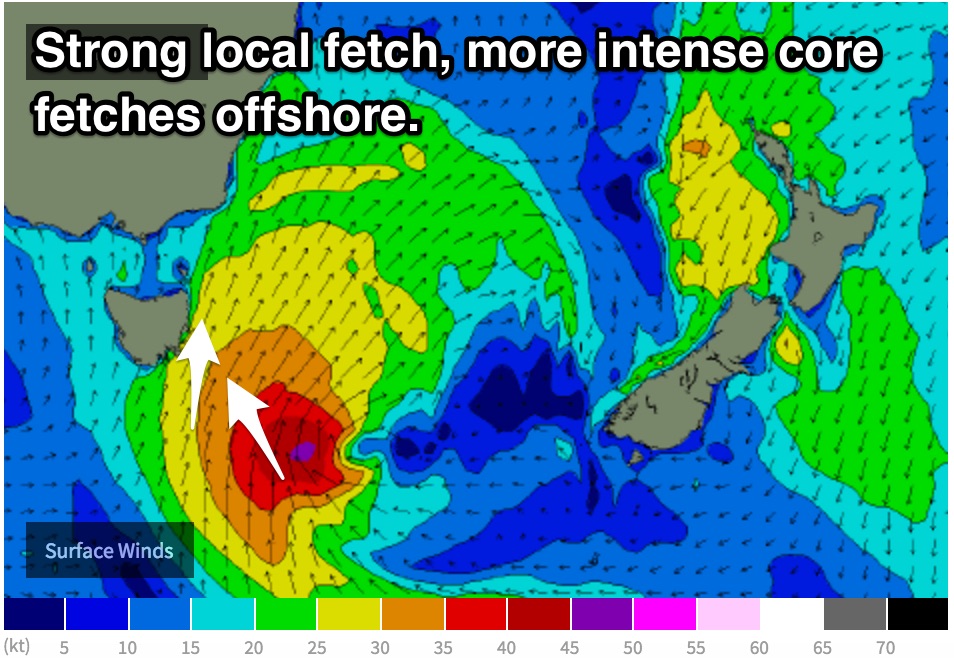
Local southerly fetches of 25-35 knots look to persist for around 24 hours from Tuesday night until Wednesday night generating a building windswell, backed up by elongated captured southerly fetches of up to 40-50kts further offshore.
Initially, the short range windswell should build across south facing beaches from Tuesday to the 3-5ft range, further on Wednesday afternoon to the 6-8ft range as the impacts of the core fetches also fill in.
Protected southern corners of the open beaches will be offering the cleanest options on Tuesday under a southwesterly breeze, tending more south/southwesterly on Wednesday. Furthermore, the surf should also be more manageable at the spots as it builds.
Southeasterly fetches off the backside of this low should maintain energy for the days following. These fetches are significantly weaker and shouldn’t add any more size, but should instead slow an easing trend.
Meanwhile, a separate source of long range groundswell should fill in from the east/northeast generated by a Tasman ridge and the impacts of TC Winston. Inconsistent sets should break across open beaches with sets in the 2-3ft range on Tuesday (more so the afternoon), easing slowly during the following days.