Fun E/NE groundswell due Tuesday

Eastern Tasmania Surf Forecast by Guy Dixon (issued Wednesday 10th February)
Best Days: Open beaches from Tuesday
Recap:
Morning sessions have been nice and clean under light/variable-offshore breezes over the past few days, although small with only 1ft or so of swell. A few peelers have been on offer for those with logs before the seabreeze kicked in late each morning.
This week (Thursday 11th - Friday 12th):
The forecast for the end of the week is looking pretty benign with no indications of substantial swell filling in.
Instead open beaches can expect background energy generated by a ridge which has been building over the Tasman to fill in, although providing little more than 1-2ft on Thursday and Friday.
Meanwhile, frontal activity over the past few days has been fairly low brow, with most fetches showing poor alignment. As a result, any southerly energy will be undersized and limited to only the very exposed magnets.
The early morning session on Thursday should see light southwesterly breezes, swinging southerly and eventually southeasterly throughout the day. Friday should again see light/variable winds early, increasing into the afternoon from the northeast.
This weekend (Saturday 13th - Sunday 14th):
A disjointed and weak north/northeasterly fetch looks to develop late on Friday evening, over eastern parts of Bass Strait, increasing in strength and becoming more consolidated throughout Saturday. However, to counter these improvements, the alignment looks to tend more northerly, with the southern extent of the fetch drifting away from the Tasmanian coast.
Open beaches will therefore have to rely on sideband energy which will be modest, peaking in the 1ft+ range on Saturday, perhaps a touch larger on Sunday morning.
Other than that, conditions look to remain small and weak.
On the plus side, we are in for a persistent northwesterly airflow on Saturday and the best part of Sunday, with only a light seabreeze a chance on Sunday afternoon.
Next week (Monday 15 onward):
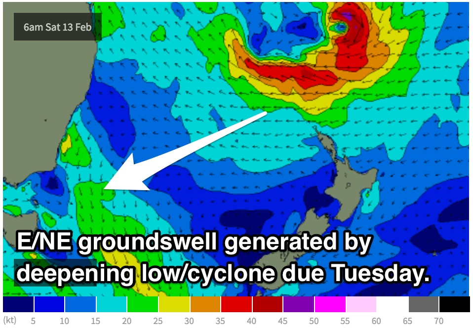 Finally, a significant swell source looks to approach the state’s northeast. Late on Monday, we should see the long period fore runners generated by a deepening tropical low/cyclone which is edging southward over the Coral Sea.
More size is due on Tuesday, with inconsistent sets building across the open beaches to around 3ft+, possibly larger at times.
Meanwhile, a strong front and cut-off low look to move over the region, with small, tight but intense southerly core fetches of up to 50kts.
In addition to a southerly local fetch upon 25-30kts, the surf has the potential to build to a choppy 3-5ft on Tuesday across south facing beaches, possibly larger late in the day and into Wednesday as the impacts of the core fetches fill in.
Meanwhile, open beaches will see the long range east/northeasterly swell fade from the 2-3ft range on Wednesday.
Monday looks to be dominated by fresh northwesterly breeze, potentially ironing out the small amount of energy in the water. Come Tuesday, breezes should be fresh southwesterly, limiting options to the open beaches, particularly protected southern corners.
By Wednesday, a fresh southerly breeze should be whipping up the coast, again, open beaches are the go.
At this stage, the cut-off low scenario has the potential to vary (as it has drastically between model runs and models throughout today), so timing and sizes are subject to change.
If all goes to plan, we should see solid southeasterly groundswell off these fetches as the move south of New Zealand later in the week.
More details to come.