Swell next Tuesday/Wednesday but with onshore winds

Eastern Tasmania Forecast by Craig Brokensha (issued Wednesday 11th March)
Best Days: No good days
Recap
Small levels of S'ly swell eased from 1-2ft yesterday with favourable winds, while today the coast is effectively flat.
 This week onwards (Mar 12 onwards)
We've got nothing on the cards at all this week, with Friday possibly seeing stray 1-2ft sets at south swell magnets from a refracted S'ly groundswell.
Into the weekend a weak change is due to push through Saturday evening but it will be very short-lived and no decent size is due off this. Again possibly 1-2ft sets at south swell magnets.
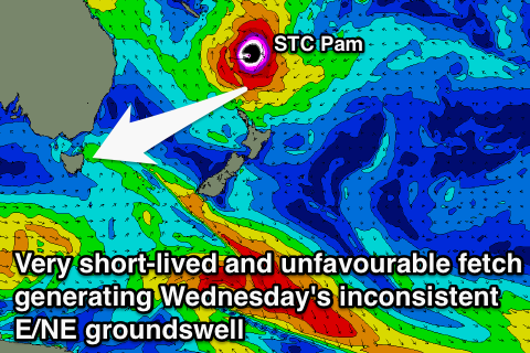
Into next week we're still likely to see some very inconsistent long-range E/NE groundswell from Severe Tropical Cyclone Pam moving south into an established trade-flow above New Zealand. Unfortunately though the trade-flow is aimed more towards Queensland compared to us and Pam will track quickly south-east once it moves into our swell window over the weekend which is also unfavourable.
Still we should see a small kick in E/NE groundswell later Tuesday, peaking Wednesday to a very inconsistent 2-3ft across open and north-east facing beaches.
Also in the mix though is likely to be some more distinguishable and more consistent NE windswell, building through Wednesday to 3-4ft across north-east facing beaches. Winds will be accordingly fresh to strong from the NE, creating poor conditions, so the outlook is generally poor.
Longer term there's nothing decent beyond the NE windswell Wednesday, but we'll have a closer look at this on Friday.