Friday afternoon best chance for a wave

Eastern Tasmania Forecast by Craig Brokensha (issued Monday 2nd March)
Best Days: Friday afternoon, the South Arm for more options
Recap
Nothing of note over the weekend with generally tiny waves varying winds.
 This week and weekend (Mar 3 - 6)
A small NE windswell slated down for tomorrow morning looks to be off the cards now, with a lack of any real fetch developing off our coast this evening and tomorrow.
That leaves the rest of the week and unfortunately there's nothing major showing on the charts until Friday afternoon.
We'll see a flurry of strong fronts push across us from tomorrow but the fetches associated with each system will be too west in nature to generate any swell for us.
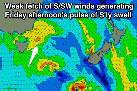
Come Thursday and Friday a better aligned system should push up past our coast aiming a weakening fetch of strong SW tending S/SW winds through our southern swell window.
With this a small kick in S'ly swell should be seen through Friday reaching 3ft or so across south swell magnets. Winds should improve through the day as well as an approaching front produces W/SW tending W/NW breezes. Therefore a scout around Friday afternoon could be fruitful.
The S'ly swell will drop rapidly overnight leaving easing and small 2ft sets at south swell magnets.
Longer term we may see another small pulse of S'ly swell during next week, but at this stage all the follow up frontal activity looks to be too west for us. Have a check back here on Wednesday for an update on this though.