Easing surf, windswell for Fri/Sat with a possible large NE swell Sun/Mon

Eastern Tasmania Forecast by Craig Brokensha (issued Monday 16th February)
Best Days: Early Tuesday, Friday morning, Sunday protected northern corners, Monday morning
Recap
Building levels of junky but solid NE windswell over the weekend with poor winds. Today the swell started to ease back from 3-4ft but as expected, early N'ly winds shifted more offshore during the day, creating great waves across most of the coast.
This week (Feb 17 - 20)
We'll see the surf continue to back off over the coming days as the trade-flow through our swell window retreated through the weekend, while the local fetch of NE winds generating the windswell has also been pushed east by today's offshore change.
There should still be 2-3ft sets on offer tomorrow morning across north-east swell magnets but winds look funky after a weak overnight SE change. We'll likely see a variable breeze through the early morning before onshore E'ly winds kick in.
Wednesday morning is only expected to offer 1-2ft sets with early light winds ahead of a gusty S'ly tending S/SE change mid-morning.
Heading into the end of the week we're expected to see building levels of NE windswell again as a broad fetch of NE winds are aimed into our coast. North-east facing beaches should build to 3ft Friday but with N/NW tending fresh N/NE winds. There may be signs of some inconsistent E/NE trade-swell from the easterly ridge re-developing through the Northern Tasman Sea.
Of much greater importance is the weekend's/early next week's swell potential discussed below.
 This weekend onwards (Feb 21 onwards)
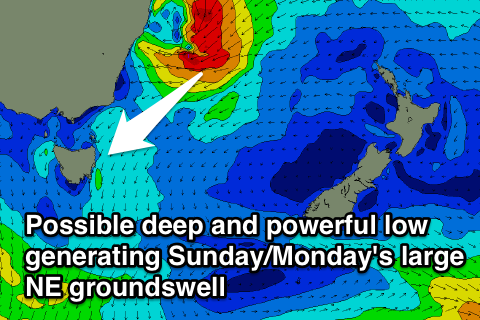
The re-developing easterly trade-flow through the Northern Tasman Sea during this week should produce good levels of E/NE trade-swell from Friday onwards in the 3ft range by itself, but... we're likely to see a tropical low in the Coral Sea slipping south down the East Coast into the trade-flow with a fetch of stronger NE gales generated in our north-eastern swell window over the weekend as it feeds of warmer than average sea surface temperatures in the East Australian Current.
If everything goes as planned we could expect a large NE groundswell pulse pushing down the coast Sunday with a possible secondary kick Monday. Winds at this stage are looking average and from the N'th Sunday but great and offshore Monday. We'll have to review this all again on Wednesday though, so check back then for another update.