NE windswell from Thursday, lots of potential into early next week

Eastern Tasmania Forecast by Craig Brokensha (issued Monday 5th January)
Best Days: Thursday afternoon, Friday morning southern corners
Recap
Plenty of NE windswell across the coast over the weekend, peaking through Sunday under morning offshores before a weak SE change moved through.
Today the swell was back to a much smaller 1-2ft under early light NW winds.
This week (Jan 6 - 9)
Tomorrow is expected to be tiny with leftover levels of NE windswell, but a new broad fetch of NE winds developing through Wednesday and persisting Thursday should kick up small levels of NE windswell into the end of the week.
North-east facing beaches are expected to build through Wednesday, from 1-2ft out of the E/NE to 2ft+ later in the day, and becoming bigger and more in the 3ft+ range through Thursday afternoon.
The fetch generating the swell is expected to be pushed away from us by a surface trough on Thursday resulting in a drop in swell from the 3ft+ range Friday morning but under SE winds.
Thursday afternoon should see winds swinging offshore from the NW through the day, cleaning up conditions while southern corners will be the go Friday morning.
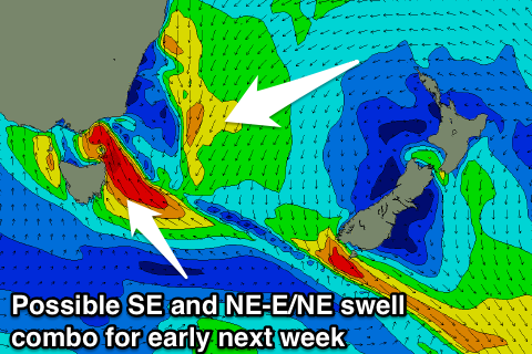 Our longer term prospects are more than interesting, with an elongated and well established trade-flow extending from about New Caledonia back over the top of New Zealand and into the Western South Pacific Ocean due to strengthen through the weekend.
The models are diverging pretty wildly on a couple of surface depressions forming in the trade-flow, with the best situation for us being that a depression forms just north and slightly to the west of New Zealand, directing the fetch more down towards us.
The swell from any of these developments won't be seen until at least early next week, and also in the mix is likely to be come close-range SE swell Sunday and Monday.
This will be linked to an inland surface trough drifting south-east and offshore during the weekend, deepening to our east and directing a fetch of strong to gale-force SE winds into us.
With this we should see building levels of SE windswell but along with poor winds.
With all the model divergence though we'll discuss both the E/NE trade-swell and SE swells in greater detail Wednesday.