Tricky period, best Saturday morning

Eastern Tasmania Forecast by Craig Brokensha (issued Wednesday 22nd October)
Best Days: Early tomorrow southern corners for a fading NE swell, Saturday morning
Recap
Yesterday was tiny across the coast, but into today a new NE swell started to develop, coming in around 2ft on the sets this morning, but a further kick to 3ft should have been seen this afternoon. Winds have gone more onshore from the N/NE though, but we may see a shift back to the N/NW on dark.
This week and Saturday (Oct 23 - 25)
Today's building N/NE windswell will fade rapidly through tomorrow as a strong S/SE change pushes up the coast, but north-east facing beaches should still be picking up the odd 2ft bomb early.
A junky increase in S/SE windswell from tomorrow's change is still on track with only a junky and weak 3ft wave due across south facing breaks and with poor S/SE tending SE winds.
The fetch of E/SE winds on the southern flank of the trough responsible for tomorrow's change isn't expected to be as good as forecast on Monday unfortunately but we'll still see small fun waves from this system.
 The swell should swing E'ly in direction through Friday but only come in at 2ft across open beaches (possibly pulsing a little stronger into the afternoon). Winds will be poor anyway and onshore from the NE tending N/NE.
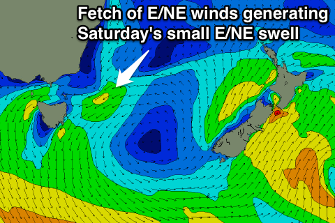
A better pulse of E/NE swell is due Saturday morning though, from the trough projecting a fetch of E/NE winds towards us Friday evening. This swell should come in at a peaky 2ft to possibly 3ft before easing through the afternoon and further from 1-2ft Sunday morning.
Conditions should be clean Saturday morning with an offshore W'ly breeze ahead of another surface trough moving offshore during the day, bringing a gusty S/SE change.
This Sunday onwards (Oct 26 onwards)
Saturday afternoon's S/SE change is expected to kick up another low quality S/SE windswell Sunday but probably only 2ft+ across south facing beaches and with fresh E'ly tending NE winds.
The outlook further into next week is complicated with the weather models diverging on how Sunday's surface trough will develop.
We may see a solid increase in NE windswell through Monday as winds swing offshore but we'll have look at this in more detail on Friday unfortunately. Check back then for another udpate.