Fun weekend, small N/NE windswell Tue/Wed

Eastern Tasmania Forecast by Craig Brokensha (issued Friday 11th July)
Best Days: Saturday in protected southern corners, Sunday for small clean waves, Wednesday morning
Recap
Yesterday and today have played out pretty much to plan with the arrival of a large and powerful E/NE groundswell during the day yesterday under strengthening SW winds. This created excellent waves in protected southern corners.
Today the swell was easing from a good but clean 3-5ft across most locations under straight offshore winds, creating excellent waves.
This weekend onwards (Jul12 onwards)
We should continue to see the current E/NE groundswell easing into this afternoon and evening across the coast due to the deep and powerful low forming over near New Zealand breaking down and swinging its fetch away from us into yesterday.
In saying this open beaches are due to persist in the 2-3ft range most of tomorrow under offshore SW tending S/SW winds, favouring southern corners. It'll really start to slow into Sunday though with a drop from 2ft+ expected and further down from 1ft to maybe 2ft Monday morning.
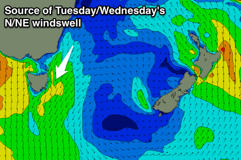 A new source of swell will develop into Tuesday and Wednesday and this will be from the N/NE as a short-lived northerly ridge develops down our coast. An infeed of strong N/NE winds should kick up messy 2-3ft waves later Tuesday with strong N/NE winds and terrible weather ahead of a drop early Wednesday as offshore NW winds kick in.
There's nothing on the cards for the end of the week but some decent S'ly swell for next weekend is still on the cards, but at this stage with no real quality. We'll review this again on Monday though and in the meantime, have a great weekend!