Good waves Tuesday/Wednesday with a SE pulse for Friday

Eastern Tasmania Forecast by Craig Brokensha (issued Monday 30th June)
Best Days: Tuesday, Wednesday, Friday, Saturday morning
Recap
Saturday was tiny and average but a strong fetch of N/NW winds down through the Tasman kicked up a small N/NE windswell for Sunday morning to 1-2ft across open beaches.
This swell faded through the day as offshore winds linked to an approaching cold front pushed the northerly ridge generating the swell away from us.
This front kicked up a good pulse of S'ly swell for today though to 3-4ft across most spots, with bigger sets at south swell magnets under offshore winds.
This swell should of eased back temporarily this afternoon as the front moved up through the Tasman, but we've got a secondary cold front currently pushing up towards us, but this is discussed in more detail below.
This week (Jun 30 – Jul 4)
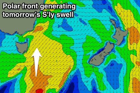 Another good pulse of S'ly groundswell is due tomorrow as a broader polar front pushes from below the state, up past our coast this evening and early tomorrow.
This should produce a solid kick in S'ly groundswell to 3-4ft+ across south facing beaches again tomorrow but winds will be a little less perfect and fresh from the W tending W/SW.
A drop in size is expected overnight Wednesday with an easing 3ft of swell left across south facing beaches but winds should be better and from the W/NW.
Now, while the frontal activity will cease after tomorrow evening, we should see one final pulse of SE groundswell on Friday as a fetch of S/SE gales wrap around a polar low stalling south of New Zealand. This should offer good 2-3ft sets across open beaches under fresh NW winds, so it may be worth planning some time off through Friday for a fun wave.
This weekend onwards (Jul 5 onwards)
Friday's SE swell is expected to slowly dip away through the weekend, with early next week showing some small E/SE swell across the coast as a weak Tasman Low starts to develop to our north-east. At this stage no major size above 2ft to maybe 3ft is expected on Monday, but there is the possibility this system could be upgraded. We'll keep an eye on this and provide an update on Wednesday.