Great S/SE groundswell with offshores tomorrow morning, fading Friday

Eastern Tasmania Forecast by Craig Brokensha (issued Wednesday 7th May)
Best Days: Thursday, Friday morning
Recap
The surf was small yesterday morning with a building S'ly swell not showing much size at dawn. A good increase was seen through the day though although winds from the southern quadrant limited options.
The S'ly swell dropped back temporarily into this morning, but an afternoon increase in strong S/SE groundswell should have been seen across the coast, generated by a fetch of severe-gale S'ly winds feeding into the low which stalled off our coast. Options would have been limited again though with S'ly winds, but more on this below.
This week (May 7 - 9)
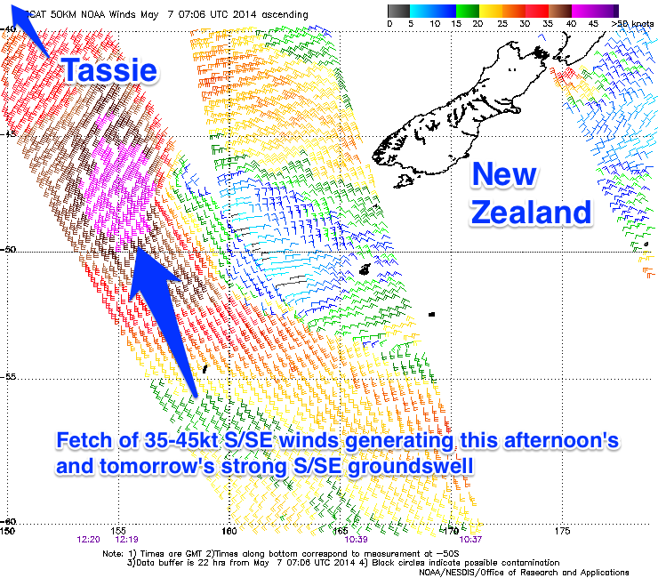 This afternoon's strong increase in S/SE groundswell should hold well into tomorrow morning, generated by a fetch of severe-gale S/SE winds projecting up and into the southern flank of the low responsible for yesterday's S'ly swell (pictured right).
A peak in size is due overnight, but tomorrow morning should still reveal solid 4-6ft waves at exposed spots, with smaller waves in protected locations and around Eagle Hawk Neck due to the origins of the swell.
Winds should improve dramatically, swinging offshore from the W/SW tomorrow morning and then variable into the afternoon as the swell eases.
Come Friday the swell will still be present but dropping quickly from 2-3ft or so under strengthening N/NW tending N'ly winds, so get in early.
This weekend onwards (May 10 onwards)
A tiny bit of residual SE swell may be seen early Saturday but besides this there's no new swell at all due over the weekend resulting in tiny to flat conditions. Into next week there's a chance of some small SE groundswell Tuesday from a deep polar low forming south-east of New Zealand, but we'll review this Friday.
In the meantime make the most of the good S/SE groundswell tomorrow and Friday morning.