Good new swell tomorrow and mid-late next week

Bali and Mentawais forecast by Craig Brokensha (issued Thursday 18th October)
Best Days: Tomorrow onwards, smallest Tuesday
This week through next week (Oct 19 - 26)
Bali: Some new S/SW swell should have filled in yesterday, and dropped through this morning, with our new long-period S/SW groundswell likely to show later today and peak through tomorrow.
This swell came in nicely across Western Australia and should provide good 5-6ft sets across exposed south swell magnets tomorrow, (smaller on the Bukit reefs) before easing later in the day, further through the weekend but softened by some mid-period reinforcing S/SW swell Sunday/Monday.
 Winds look to remain out of the S/SE from tomorrow through the weekend, variable in the mornings, before taking a more S/SW bias through next week.
It doesn't look like the trades will kick in at all through this period.
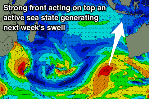
Looking at our new S/SW groundswell due mid-next week, and the polar frontal progression firing up south-west of WA has been strengthened. A pre-frontal fetch of severe-gale W/NW winds is due to be followed by a good post-frontal fetch of strong to gale-force SW winds and then final stronger burst of SW gales projected towards WA.
We should see an initial small increase in S/SW groundswell from the pre-frontal fetch on Tuesday, building to 4ft at south magnets, with the larger groundswell building Wednesday to 6ft to possibly 8ft, easing from a similar size Thursday, back from 5-6ft Friday and smaller into the weekend.
16 day Bali Forecast Graph
16 day East Java Forecast Graph
16 day Sumbawa Forecast Graph
Ments: We should be seeing some new long-period S/SW groundswell energy building across the region this afternoon, with a peak due tomorrow to 4-6ft across south facing breaks, slowly dropping through the weekend with the mid-period S'ly energy.
With the slight upgrade in the frontal passage projecting towards WA, we should see some fun S/SW groundswell energy spreading radially up towards us, building Wednesday afternoon to 4-6ft at south facing breaks by dark, easing from a similar size on Thursday.
Looking at the winds and the small tropical low that's currently bringing winds from the western quadrant will move slowly south-east overnight resulting in better E/NE winds across the southern Ments tomorrow morning, NW to the north with S/SE winds developing into the afternoon across the south.
We're then due to see a return to morning SE breezes and afternoon S'ly winds from Saturday, persisting next week.
16 day Mentawai forecast graph
16 day Nias forecast graph
16 day South Sumatra forecast graph