Swell of the season followed by extra-large surf next week

Bali and Mentawais forecast by Craig Brokensha (issued Tuesday 24th July)
Best Days: Experienced surfers only over the coming period, in protected spots in the Ments
This week and next (Jul 25 – Aug 3)
Bali: After easing through the weekend, a strong new long-period SW groundswell pushed in yesterday, generated by a tight mid-latitude low that formed south-east of Madagascar last week before tracking east.
This provided strong sets at swell magnets, but today, we're now seeing the fore-runners of the biggest swell of the season pushing in, producing large dangerous and building surf across most of Indonesia.
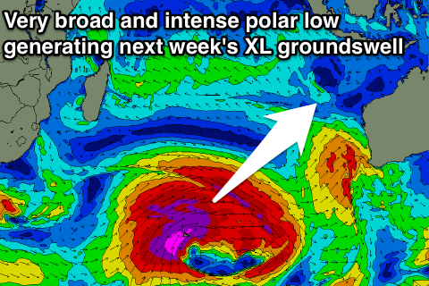
Through late last week and the weekend we saw a very significant polar storm developing in the Heard Island region and projecting slowly up into the south-east Indian Ocean in a 'captured fetch' motion, higher in latitude than normally seen.
This was due to a strong protruding node of the Long Wave Trough stalling just west of Western Australia, and the swell impacted their region Sunday evening and yesterday, producing some of the largest readings in years on the local wave buoys.
As a result we can expect the surf to come in very very large and powerful across our region later today, peaking tomorrow morning in the 12ft to likely 15ft range at exposed breaks, large even in super protected spots and only for experienced surfers.
The swell should start easing through the day, dropping from a still extra-large 10-12ft Thursday morning and more manageable 8ft range Friday morning.
Fresh and gusty E/SE trades will persist through tomorrow, swinging more SE in direction from Thursday and easing off from Sunday. Early each morning we should see more variable breezes, lasting longer on the days with weaker trades.
Into Saturday a new large consistent SW groundswell is due to fill in, produced by a mid-latitude front that's currently projecting east through the Indian Ocean.
While not especially strong this front will project a good fetch of W/SW gales relatively close to Indonesia, with the swell building through Saturday, peaking later and then easing Sunday.
It won't be as big as the models are forecasting, with the existing swell being incorrectly combined with the new energy, but we can expect exposed breaks to kick back to 8ft on the sets through the afternoon, dropping back from 6-8ft Sunday.
 Of greater importance is a much larger and more powerful long-period SW groundswell due across the region Monday.
A few days ago the models were forecasting this swell to be similar in scope to the current building XXL groundswell, but it now looks to be just under.
Currently a vigorous polar low is forming west of Heard Island, with a fetch of severe-gale to near storm-force W/NW winds, creating an active open ocean sea state for a much broader and expansive fetch of storm-force W/SW winds to move over, projecting slightly north-east towards us through the middle of this week.
An extra-large long-period SW groundswell will be generated, with the fore-runners arriving Sunday and kicking large late in the day.
We'll see the groundswell fill in proper on Monday and peak through the day to what looks to be 10-12ft+. Following this it looks like we'll see the Indian Ocean settle down to normal levels, but more on this Thursday.
16 day Bali Forecast Graph
16 day East Java Forecast Graph
16 day Sumbawa Forecast Graph
Ments: Today we're seeing the XXL S/SW groundswell filling in across the region along with fresh SE-S/SE winds, favouring protected breaks.
The swell should peak tomorrow in the 12ft+ range across exposed breaks, easing through the afternoon and down further into Thursday and Friday.
Fresh SE winds will persist through the end of the week and most of the forecast period, limiting options with the coming swells.
The new S/SW groundswell for Saturday was generated a touch later in our swell window, and as a result we're looking at surf to 6-8ft, under the incorrectly combined model forecasts.
We then look ahead to the extra-large long-period S/SW groundswell for Sunday/Monday. The swell will arrive a touch earlier across the Ments and should kick to an easy 10ft by dark at magnets Sunday, peaking Monday morning to 10-12ft, easing back slowly through the afternoon and further into the middle of the week and bottoming out Friday.
We may see a new moderate to large S/SW groundswell for the weekend, but have a check back Thursday for more on this.
16 day Mentawai forecast graph
16 day Nias forecast graph
16 day South Sumatra forecast graph
Comments
fark what a run of swell they're having...
Swell hit overnight - Ulu looking 15FT + and Kermas well over 8-10ft..Keramas shoreline getting ripped apart at moment
Macking.
A Man on the Ulu cliffs says 30ft faces at O.C.
Need the camera to pan across...
Need a report from Mark Flint ?
Whats the best cam site to use Craig
balibelly - lots of cams
Lowtide around 3pm gonna b interesting
Thanks Udo
Nias this morning from Mark Healey.
I'd hate for the IT guy to see how often I'm alt-tabbing between work and various surf sites at the moment haha.
jesus christ......be no excess board charges for flights home...be none intact
And Kip Caddy's stories :o
https://www.instagram.com/kippcaddy1/
ungodly amount of water moving at keramas. Keep the links comming boys!
And my friend is in Nias, check her stories, some horrific doubleup beatdowns!
https://www.instagram.com/mincook88/
Felipe 'Gordo' Ceserano windmilling into a thick Nias double up. Filmed yesterday...
Gordo, right?
Kipp Caddy gets an early entry before the step doubles up:
Massive Nias. There is someone on it though cant tell if they make it.
Someone just lost their boat
Geezus...I've never seen it that big with that amount of water moving around...hectic!!
I don't think I've seen footage of Ulus this big before.
TedGrambeau got a pic from channel of that boat going over
Ted reckons he got a live feed...how do we get that ?