Easing surf ahead of a good S/SW swell Saturday, larger Monday

Bali and Mentawais forecast by Craig Brokensha (issued Tuesday 24th April)
Best Days: Exposed breaks over the coming days then the marquee reefs Saturday through Tuesday next week
This week and next (Apr 25 – May 4)
Bali: Our large powerful SW groundswell filled in through Sunday afternoon, peaking yesterday across the region under moderate to fresh trades. Unfortunately Wollongong surf Jae Haydon lost his life surfing Uluwatu. RIP mate.
The swell has eased off into today and will continue to drop through tomorrow and Thursday, bottoming out Friday morning. A new S/SW groundswell later in the day, peaking Saturday.
This swell has been generated by a strong and slow moving polar frontal progression that developed over the weekend and the last couple of days in the Heard Island region, projecting slowly towards WA.
 We're looking a touch more size than forecast last Thursday with the progression being a little stronger. With this we should see a late pulse in size Friday to 4-5ft+ across magnets, peaking Saturday to 6ft to possibly 8ft.
The swell should ease off later in the day, dropping further into Sunday ahead of a new S/SW groundswell late in the day and larger pulse Monday.
This secondary swell has also been upgraded in size, with two seperate pulses due.
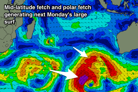
We're due to see a broad and vigorous polar low and mid-latitude front fire up in our swell window over the coming days, with the mid-latitude storm generating a fetch of W/SW gales, followed by a stronger polar fetch of severe-gale to storm-force SW winds.
The W/SW fetch should generate a S/SW groundswell for late very late Sunday but more so early Monday in the 5-6ft+ range. The larger long-period energy from the polar low will override this through the morning, kicking to a bigger 8ft to occasionally 10ft across magnets again through the day.
Conditions should be good with favourable E/SE trades, persisting but easing as the swell eases steadily through Tuesday and Wednesday.
Longer term there's nothing too major on the cards besides a reinforcing mid-period SW swell late next week, but more on this in the next update.
16 day Bali Forecast Graph
16 day East Java Forecast Graph
16 day Sumbawa Forecast Graph
Ments: The past couple of days of large pumping SW groundswell is now on the ease and we'll see the surf continuing to drop into Thursday and Friday morning but with a bit of wind from the N/NW owing to a trough to our west.
The new S/SW groundswell due late week should fill in Friday afternoon, pulsing to 4-5ft+ across exposed south facing breaks and then easing from a similar size range Saturday morning as winds tend more variable.
The large S/SW groundswell is due to peak Monday across the Ments as well, coming in a little under Bali's size with 6-8ft sets due across south magnets all day, easing back into Tuesday, further Wednesday.
Winds are set to remain variable through early next week, with a slight S/SE tendency from Thursday. There's nothing too major due swell wise with a mid-period kick Thursday to 4-5ft+, but we'll have a closer look at this next update.
16 day Mentawai forecast graph
16 day Nias forecast graph
16 day South Sumatra forecast graph