Good S/SW swell tomorrow, easing into the weekend, plenty to come next week

Java, Bali, Lombok, Sumbawa forecast by Craig Brokensha (issued Tuesday 9th August)
Best Days: Every day over the coming period besides Saturday afternoon and Sunday when the swells become small
This week and next (Aug 10 - 19)
We're currently seeing a moderate to large S/SW groundswell building across exposed breaks, generated by a polar front projecting up towards WA before then spawning into a mid-latitude low, stalling off south-west WA coast over the weekend.
This stalling low has been aiming persistent SW gales towards us, with the largest increase in S/SW groundswell due tomorrow.
Today we should see exposed south facing breaks reaching 6ft to possibly 8ft through the afternoon, with tomorrow's pulse, kicking a bit stronger to a more consistent 8ft on the sets. Smaller surf will be seen on the Bukit reefs with the southerly angle of the swell.
With the low moving off under Australia today, we'll see the swell dropping through Thursday from 6ft to occasionally 8ft, further down through Friday and Saturday, bottoming out Sunday and becoming tiny.
 Moderate to fresh E/SE trades are expected over the coming period, (light and variable each morning), strengthening through the weekend and persisting into most of next week.
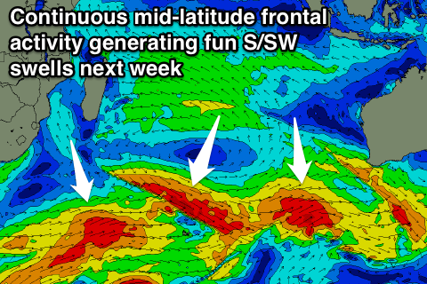
From next week we'll see a ton of S/SW groundswell activity, produced by back to back polar frontal systems pushing into the mid-latitudes towards WA.
There isn't really one standout system, but more so back to back and close fetches of pre and post-frontal gales through our southern swell window.
Size wise, each pulse looks to come in around the 6ft+ range across exposed breaks from Monday through Friday next week, with the largest increase for Thursday likely to come more from the SW and be in the 8ft range on the sets. More on this Thursday though.
16 day Bali Forecast Graph
16 day East Java Forecast Graph
16 day Sumbawa Forecast Graph