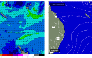
High pressure is now weakening with the angled monsoon trough stretched along the edge of the Coral Sea still supplying sufficient pressure gradients to maintain a tradewind flow which is generating small, fun surf.
Primary tabs
/reports/forecaster-notes/central-queensland/2023/03/24/grab-the-last-the-fun-surf-weekend- -tiny
freeride76
Friday, 24 March 2023
/reports/forecaster-notes/central-queensland/2023/03/22/few-more-fun-days-ahead-the-end-in-sight
freeride76
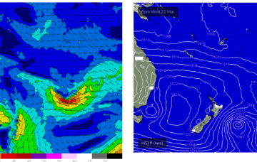
Wednesday, 22 March 2023
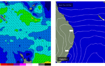
High pressure has now moved into the Tasman, reinforcing tradewinds in the Coral Sea.
/reports/forecaster-notes/central-queensland/2023/03/20/ fun-waves-keep-coming-active-coral-sea
freeride76
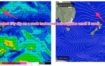
Monday, 20 March 2023
Tradewinds have been active through the Coral Sea, anchored by a small E’ly dip SW of New Caledonia. With the tradewinds fully established we are seeing a fully developed sea state through the Central/Southern Coral Sea which will keep fun waves chugging along through this week.
/reports/forecaster-notes/central-queensland/2023/03/17/extended-run-fun-surf-ahead
freeride76
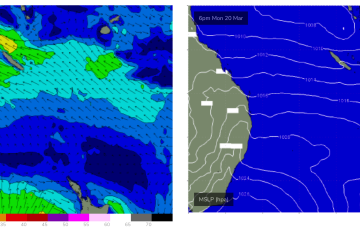
Friday, 17 March 2023
Also on the radar next week we’ll be watching a low pressure system in the Coral Sea which has been lingering for days as a diffuse system. There looks to be more organisation later next week, possibly with a S-SE recurvature if the system intensifies into a tropical cyclone.
/reports/forecaster-notes/central-queensland/2023/03/10/flat-spell-ahead
freeride76
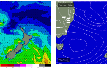
Friday, 10 March 2023
Weak high pressure and a monsoon trough across the Top End linked to a monsoon low in the Gulf are leading to very light winds across the Coral Sea and tiny/flat surf.
/reports/forecaster-notes/central-queensland/2023/03/08/ surf-becoming-tiny-the-weekend
freeride76
Wednesday, 8 March 2023
Expect tiny surf to continue over the weekend and into early next week as a trough off NSW disrupts the tradewind flow from a new high drifting into the Tasman.
/reports/forecaster-notes/central-queensland/2023/03/06/few-small-windows-ahead-better-outlook-next
freeride76
Monday, 6 March 2023
Across the Coral Sea we’ll see a slight increase in tradewinds around a broad E’ly dip near New Caledonia which will perk wave heights up through Wed into the 1-2ft range, albeit with N’ly winds.
/reports/forecaster-notes/central-queensland/2023/03/03/easing-surf-ahead-tcs-judy-and-kevin-races
freeride76
Friday, 3 March 2023
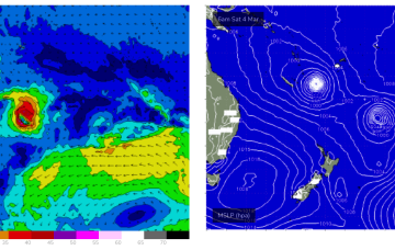
A weak ridge from a high (1023hPa) tracking towards Tasmania supplies light winds tomorrow while TC Judy and Kevin both race away to the SE, supplying very little surf to the region.
/reports/forecaster-notes/central-queensland/2023/03/01/not-much-surf-ahead-tc-judy-races-away-the-se
freeride76
Wednesday, 1 March 2023
The tropics remains active with a monsoon trough and convective activity strewn across the Top End, while the edge of the trough in the South Pacific has spawned TC Judy, with another system behind it. Both of those systems are now modelled to track quickly SE through the swell window with no major swells generated.
/reports/forecaster-notes/central-queensland/2023/02/27/downgraded-surf-outlook-depressions-race-away
freeride76
Monday, 27 February 2023
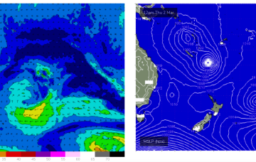
The troughy pattern will see a weakening trade flow in the Coral Sea this week and while all eyes are on the tropics it’s looking like a continuing tease with an expected tropical depression or TC moving quite quickly SE through the swell window with limited surf potential.
