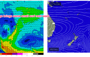
We’ll see a SE surge with the high pressure ridge and a small increase in swell from Wed across the CQ coast.
Primary tabs
/reports/forecaster-notes/central-queensland/2024/09/02/fun-waves-wed-se-surge
freeride76
Monday, 2 September 2024
/reports/forecaster-notes/central-queensland/2024/08/30/bit-more-action-next-week-se-surge
freeride76
Friday, 30 August 2024
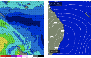
We’ll see stronger SE surf develop Wed/Thurs as a SE surge propagates up the QLD coast from a strong high pressure ridge
/reports/forecaster-notes/central-queensland/2024/08/28/small-waves-week-bigger-waves-next-week
freeride76
Wednesday, 28 August 2024
A sub-tropical low SE of Fiji is sending small waves to open stretches of the Burnett Coast with this swell source expected to continue as the system slowly drifts through the South Pacific.

/reports/forecaster-notes/central-queensland/2024/08/26/tiny-waves-week-possible-waves-next-week
freeride76
Monday, 26 August 2024
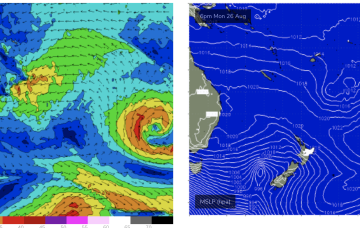
A fetch well to the SE of Fiji this week will supply a small, background signal of E swell from Wed for those spots with open access to the E.
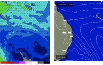
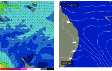
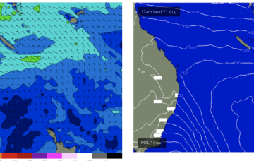
/reports/forecaster-notes/central-queensland/2024/08/21/small-peelers-the-weekend
freeride76
Wednesday, 21 August 2024
There’s just enough strength in the tradewind flow through the central Coral Sea to see some small surf develop across the CQ coast. That should hold surf into Sat before easing.
/reports/forecaster-notes/central-queensland/2024/08/19/tiny-start-becoming-rideable-mid-week
freeride76
Monday, 19 August 2024
High pressure systems are looking weak and mobile as befits the changing seasons, tracking NE into the Tasman and bringing a N’ly flow across sub-tropical to temperate regions but holding enough strength in the Coral Sea to generate some small rideable waves from mid-week.
/reports/forecaster-notes/central-queensland/2024/08/16/surf-easing-over-the-weekend-becoming-tiny
freeride76
Friday, 16 August 2024
Our summer-style swell producing pattern has broken down and we’re seeing surf ease into the weekend, becoming tiny into next week as high pressure moves towards Tasmania.
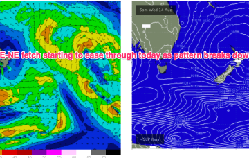
/reports/forecaster-notes/central-queensland/2024/08/14/pumping-surf-easing-the-weekend
freeride76
Wednesday, 14 August 2024
A summer style pattern is seeing tropical moisture dragged down the East coast by a trough and deep E/NE-NE flow from a large high in the Tasman, generating large swells for Central QLD.
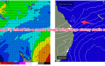
/reports/forecaster-notes/central-queensland/2024/08/12/solid-onshore-surf-good-part-week
freeride76
Monday, 12 August 2024
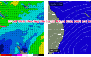
We have a strong (1033hPa) high in the Tasman, with a deep E’ly flow through the Coral Sea feeding into a coastal trough along the QLD coast. That trough is drawing down plenty of tropical moisture in the deep onshore flow, and generating sizey, stormy E’ly swells for the sub-tropics.
/reports/forecaster-notes/central-queensland/2024/08/09/out-season-pumping-surf-next-week
freeride76
Friday, 9 August 2024
No change expected to the broad pattern next week with strong high pressure moving into the Tasman and a broad, deep E’ly fetch developing through the Coral Sea, with an embedded trough.