The final low in the sequence is tracking below Tasmania today and it's a little better positioned, and should provide a late kick on Wednesday afternoon across south facing beaches.
Primary tabs
/reports/forecaster-notes/sydney-hunter-illawarra/2017/06/12/late-wed-and-thurs-new-sly-swell
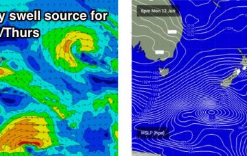
thermalben
Monday, 12 June 2017
/reports/forecaster-notes/sydney-hunter-illawarra/2017/06/09/easing-swells-funky-winds
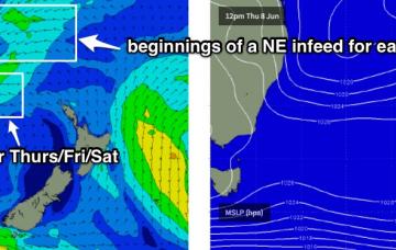
thermalben
Friday, 9 June 2017
This is our current source of easterly swell for the region, so as it exits our swell window we’ll see a gradual easing of the source fetch and thus a slow drop in surf size.

/reports/forecaster-notes/sydney-hunter-illawarra/2017/06/07/stacks-swell-ahead-sydney-tricky-winds
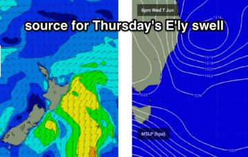
thermalben
Wednesday, 7 June 2017
I’m kinda surprised we haven’t seen more size across Sydney beaches today. If you’d looked at today’s buoy readings in a few months time, and then been asked to estimate how big the surf was - with significant heights over 4m and maximum heights of 8m - I reckon you’d guess a lot bigger than 3-4ft at south facing beaches.
/reports/forecaster-notes/sydney-hunter-illawarra/2017/06/05/thursday-pick-forecast-period-sydney
thermalben
Monday, 5 June 2017
We have an active week on the synoptic charts.
/reports/forecaster-notes/sydney-hunter-illawarra/2017/06/02/easing-southerly-swells-over-weekend
thermalben
Friday, 2 June 2017
Next week's forecast has thrown a range of curveballs over the last few days.

/reports/forecaster-notes/sydney-hunter-illawarra/2017/05/31/windy-next-few-days-improving-steadily
thermalben
Wednesday, 31 May 2017
The weekend’s easing trend now looks like it’ll occur more slowly than previously though, though it’ll be steadily down nonetheless.
/reports/forecaster-notes/sydney-hunter-illawarra/2017/05/29/plenty-swell-south-windy-times
thermalben
Monday, 29 May 2017
Let’s take a closer look on Wednesday to assess the chance of their being periods of good winds on Thursday and Friday to capitalise on.
/reports/forecaster-notes/sydney-hunter-illawarra/2017/05/26/small-surf-short-term-complex-outlook
thermalben
Friday, 26 May 2017
Only small surf this weekend, though conditions should be clean with mainly light winds.
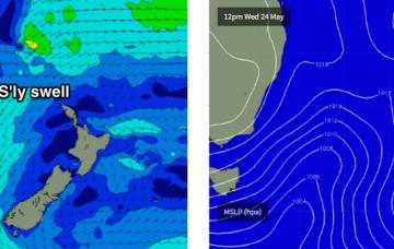
/reports/forecaster-notes/sydney-hunter-illawarra/2017/05/24/small-swells-tasman-then-south-pacific
thermalben
Wednesday, 24 May 2017
There's nothing of any great interest for the next few days.
/reports/forecaster-notes/sydney-hunter-illawarra/2017/05/22/easing-se-swell-tuesday-small-ene-swell
thermalben
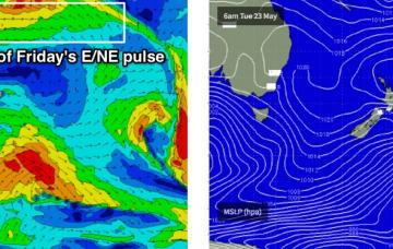
Monday, 22 May 2017
And this forms the crux for the initial short term forecasting decision - how much size will hold true overnight?