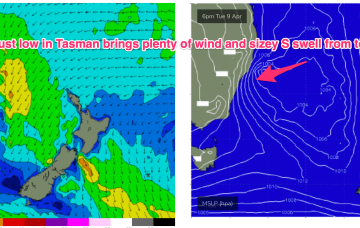
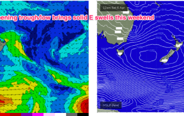
That’s allowing plenty of space for low pressure development in the Tasman and as a front pushes through and combines with the remnants of a trough we’ll see a robust low develop through tomorrow, with gales expected close to the coast.
Primary tabs
/reports/forecaster-notes/sydney-hunter-illawarra/2024/04/08/windy-week-low-spins-sydney-plenty-swell
freeride76
Monday, 8 April 2024
/reports/forecaster-notes/sydney-hunter-illawarra/2024/04/04/improving-conditions-weekend-coastal
freeride76
Friday, 5 April 2024
The moist onshore flow from this set-up is flowing into a coastal trough and interior low bringing onshore winds and rain. We’ll eventually see the low clear the coast bringing better winds Sun with some strong S swell pulses on the menu from Sun and into next week from Tasman Sea and deeper sources.
/reports/forecaster-notes/sydney-hunter-illawarra/2024/04/03/poor-end-the-week-large-and-improving
Craig
Wednesday, 3 April 2024
Onshore winds will strengthen over the coming days, feeding into a deepening trough. The swell will peak on the weekend as conditions slowly improve.
/reports/forecaster-notes/sydney-hunter-illawarra/2024/03/31/looking-juicy-weekend-low-tracks-down
freeride76
Monday, 1 April 2024
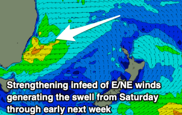
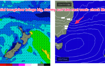
A complex inland trough low tied to tropical sources exits the coast as a strong high moves into the Bight. Following that a coastal trough in the Northern Tasman then deepens, likely into a surface low which may drift southwards bringing strong E swells to the entire region, possibly followed by a return S swell as the low gets captured by an approaching front.
/reports/forecaster-notes/sydney-hunter-illawarra/2024/03/28/small-and-clean-easter-more-dynamic
freeride76
Friday, 29 March 2024
From Wed onwards we’ll see a much more dynamic pattern in the Tasman. The inland low will exit near the Gippsland coast and conjoin with a front as a major new high pushes in behind from the Bight.
/reports/forecaster-notes/sydney-hunter-illawarra/2024/03/27/intermittent-south-swells-the-next-few
thermalben
Wednesday, 27 March 2024
Weak coastal troughiness will contract to the North Coast on Thursday though lingering onshore SE winds are a risk north from Sydney.
/reports/forecaster-notes/sydney-hunter-illawarra/2024/03/25/s-pulses-leading-easter-pockets-ok-0
freeride76
Monday, 25 March 2024
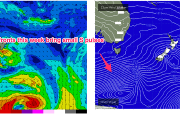
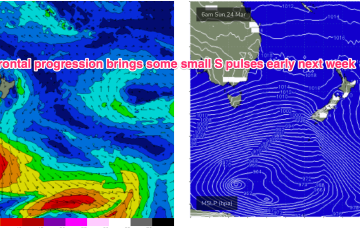
For now, frontal activity is being allowed to track in a more favourable manner for S swell production so we’ll seea week of small/moderate S swell pulses leading into the Easter weekend.
/reports/forecaster-notes/sydney-hunter-illawarra/2024/03/25/s-pulses-leading-easter-pockets-ok-wind
freeride76
Monday, 25 March 2024
For now, frontal activity is being allowed to track in a more favourable manner for S swell production so we’ll see a week of small/moderate S swell pulses leading into the Easter weekend.
/reports/forecaster-notes/sydney-hunter-illawarra/2024/03/21/small-fun-weekend-ahead-series-s-pulses
freeride76
Friday, 22 March 2024
S swells from frontal activity now look a notch more active next week as the W-E progression of the next high cell (and subsequently fronts) slows and allows more intrusion into the lower Tasman.
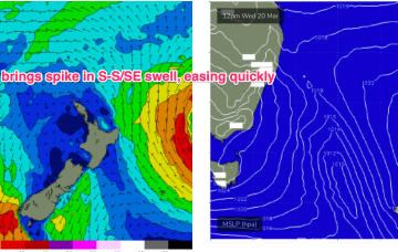
/reports/forecaster-notes/sydney-hunter-illawarra/2024/03/19/spike-in-windy-s-swell-then-easing-trend
freeride76
Wednesday, 20 March 2024
The NZ high has generated a useful fetch of tradewinds in the eastern swell window, which has maintained E’ly swells in the sub-tropics, E/NE in temperate regions. That trade fetch breaks down in the short term before rebuilding again at more Northern latitudes. We’ll see some frontal activity over the weekend before another strong, blocking high sets up a ridge next week.