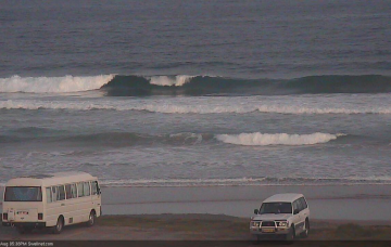
Obviously, with ideal winds out of the south, all road should lead to the SE Qld points. By and large, they will be your best bet but we need to factor in a significant drop in size because of the generally low periods and southerly swell direction.
Primary tabs
/reports/forecaster-notes/south-east-queensland-northern-new-south-wales/2018/08/17/lots-southerly
thermalben
Friday, 17 August 2018
/reports/forecaster-notes/south-east-queensland-northern-new-south-wales/2018/08/15/extended-round
thermalben
Wednesday, 15 August 2018
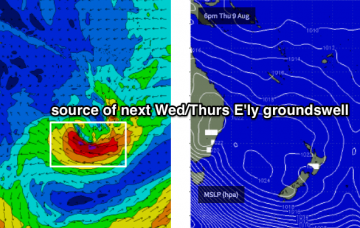
The big question mark for Thursday is the long range east swell that’s been discussed in this notes for the last week or two.
/reports/forecaster-notes/south-east-queensland-northern-new-south-wales/2018/08/13/flukey-swells
thermalben
Monday, 13 August 2018
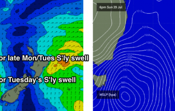
We’re back to an extended southerly swell regime across the East Coast. However, as has been discussed for the last couple of weeks, we also have some inbound E’ly energy from several sources in the South Pacific - one way out south of Tahiti mid-late last week, and another low that developed N/NE of New Zealand over the weekend.

/reports/forecaster-notes/south-east-queensland-northern-new-south-wales/2018/08/10/tricky-winds-and
thermalben
Friday, 10 August 2018
Set waves will be equally as inconsistent as what we’ve seen over the last 72 hours, but a bigger risk on Saturday - especially across the Mid North Coast - is a freshening northerly breeze.
/reports/forecaster-notes/south-east-queensland-northern-new-south-wales/2018/08/08/extended-run
thermalben
Wednesday, 8 August 2018
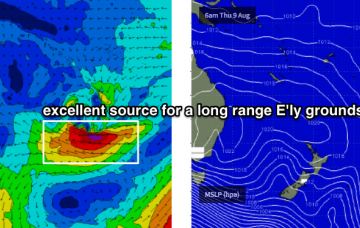
We’re still expecting an extended period of long range E’ly swell for northern parts of the East Coast through next week, and possibly even into next weekend, however most of the source developments will occur well south of Tahiti - which is a very long way away from the mainland.
/reports/forecaster-notes/south-east-queensland-northern-new-south-wales/2018/08/06/extended-run-ely
thermalben
Monday, 6 August 2018
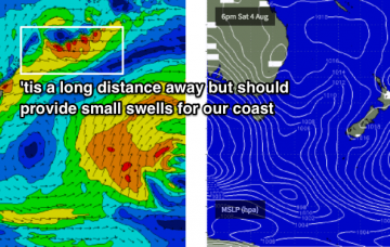
All of my attention is currently focused on the long range charts of the South Pacific.
/reports/forecaster-notes/south-east-queensland-northern-new-south-wales/2018/08/03/extended-period
thermalben
Friday, 3 August 2018
There ain't much happening this weekend in the surf department.
/reports/forecaster-notes/south-east-queensland-northern-new-south-wales/2018/08/01/small-tricky
thermalben
Wednesday, 1 August 2018
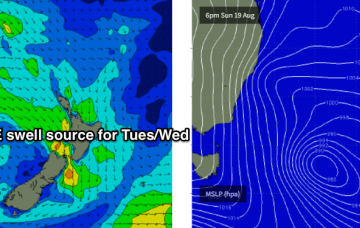
Also worth keeping an eye out for from Friday onwards: a small subtropical low developed north of New Zealand today, performing much better than Monday’s model guidance indicated.
/reports/forecaster-notes/south-east-queensland-northern-new-south-wales/2018/07/30/another-week
thermalben
Monday, 30 July 2018
Small south swells this week, with exciting possibilities out of the east for next week.
/reports/forecaster-notes/south-east-queensland-northern-new-south-wales/2018/07/27/poor-weekend
thermalben
Friday, 27 July 2018
I’m all out of interesting adjectives. Let’s cut to the chase: SE Qld won’t see any worthwhile surf this weekend.