Sand Nourishment Trial For The Sunshine Coast

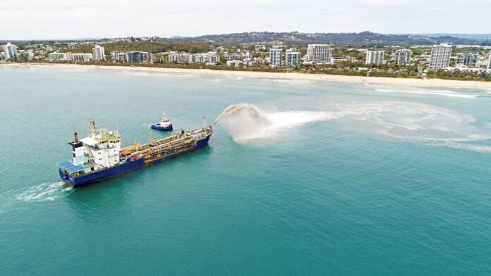
Beginning on the 16th November, Sunshine Coast Council (SCC) will trial a sand nourishment program.
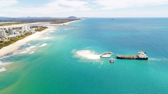
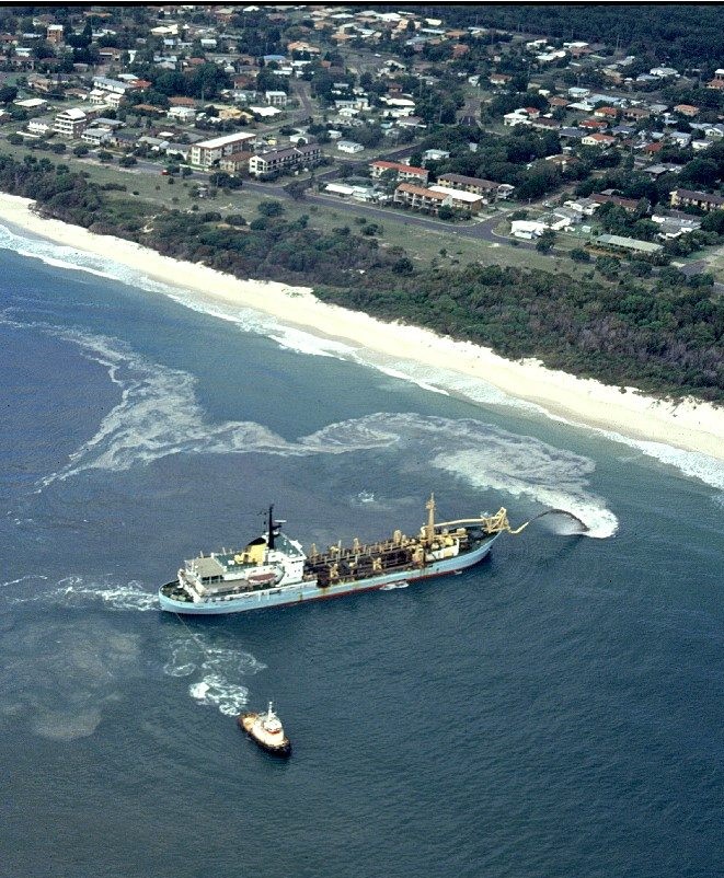
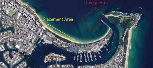
Using an ocean-going dredge, the vessel will dredge sand from Spitfire Channel - between the southern end of Bribie Island and the northern end of Moreton - and dump it offshore from Alex Beach. The sand may be released via "bottom placement" or "rainbowing". The former is when the hull splits and directly releases the sand load into the water offering a more accurate and concentrated dump, while the latter diffuses the sand over a wider area and looks just great in photos.

The dredge will operate continuously 24 hours a day up until the 24th November, weather permitting.
There are reasons for Sunny Coast surfers to rejoice, though they'd better wait to see the results before cheering too loudly.
Rather than drop the sand randomly, engineers at SCC plan to account for surfing amenity and place it where it has the best opportunity to improve surf conditions. From the Council website:
"We have been working hard to trial placement shapes that may improve surf amenity along Maroochydore beach. We have been working with engineers that were a part of the Gold Coast Nourishment campaign for the Commonwealth Games to learn from their placement techniques so that Maroochydore can have the best chance at improved surf amenity."
"We will also work with the University of the Sunshine Coast to analyse the surf before, during and after the placement to see if surf amenity has improved."
The Gold Coast has a long history of sand nourishment programs, including dredge and dump operations. In 2017, Gold Coast City Council (GCCC) ran a five month nourishment program that shifted three million cubic metres of sand from offshore reserves into the nearshore zone. The project resulted in good, if shortlived, banks at many beaches on the Gold Coast.
The reason Sunshine Coast surfers should temper their excitement is because the coming program will shift much less sand. Just 30,000 cubic metres of sand will be dredged and dumped.
The best outcome would be for the sand to be released via bottom placement which has less dispersal, leading to shallower banks and a greater chance of influencing wave shape. At any rate, this is only a trial program tailored to provide evidence that may guide any further nourishment work.
It will be possible to track where the vessel dumps its load on our Alex Beach surf cam.
Comments
Flows straight to Mooloolah Bar blocking it off, dredge wars.
Ha, knew you'd have something positive to say ;)
Why the flow south, and not north?
Great for the economy lol.
Spring not Winter.
Either way, hopefully fills in some gutters/holes for the crew down there.
It was originally planned for last March. But after the flooding of the SEQ region in February, the contracted dredger was needed to do remedial dredging in the Brisbane River. Then there was no weather window available in April, and the next available slot is this month.
But I think your not far off the money, it's more about the possible economic benefit from a more family friendly and clubby carnival suitable sandy beach, than it is about creating banks for surfers.
Spitfire banks, legendary Bribie secret spot RIP
But wouldn't deeper water allow more swell to dribble ashore at Bribie?
We don't trade in our big wave spots for a few extra Shoreys Stu.
Dredging *shouldn't* immediately impact spitfire banks Steve cos it's supposedly occurring in the channel. Spitfire banks are located in the large Marine National Park area (= Green Zone) so one would hope that dredging wouldn't be occurring there. Probably just finding a new place to dump the spoil from the 365 day a year channel maintenance the Port Corp undertakes (2 birds, 1 stone argument). Stu - i dont think this dredge could solve the Carties/Mooloolah river issue as it is too big to work so shallow/close to shore.
Further to what Sprout has said, and sorry to state the obvious, but if sand blocking the Mooloolah rivermouth is a problem, why not just dredge that sand and move it to Alex (less than 2km) instead of bringing sand in from spitfire (a lot further than 2km)?
Fingers crossed for some nice sand formations!
I wondered about that also, went looking for answers but apparently it's not a Frequently Asked Question. Thought it'd be the proverbial 'two birds, one stone' solution.
They are, however, taking some sand from the Maroochy River.
Good point Stu, lucky enough to learn my chops at Woorim.
Deeper bottom,perfect direction NE,
Sw winds
Bloody hell
Could be all time!
Another question.
Why dump sand at all in front of Alex/Sharks?
Is there erosion occurring there?
It seems a bit arbitrary.
From the SCC website:
"Maroochydore Beach has been subject to significant erosion events and the addition of new sand from an external source will help to restore sand to the beach and protect the area from erosion."
Surfed it a few weeks back and the beach was narrow with rock in the shoreys. First time surfing there so I thought that was natural, but perhaps not.
There's alot of sand gone from alot of the coast at the moment, storm bars, alot sitting high up the dunes too. Steep, thin beach, gutters, etc. Non-stop E swell assault, said it before, shows how dependant we are on S Winter flat spells for good sand.
Yeah as Stu said, lots of exposed coffee rock, right into the wave zone.
Further...
https://www.sunshinecoast.qld.gov.au/Council/Planning-and-Projects/Infra...
https://www.sunshinecoast.qld.gov.au/Council/News-Centre/Sandsational-pr...
https://www.google.com/url?sa=t&rct=j&q=&esrc=s&source=web&cd=&cad=rja&u...
Why is the Nearshore Beach Nourishment trial happening at Maroochydore Beach?
Studies show that there is a limited supply of sand on the Sunshine Coast. Maroochydore Beach has been subject to significant erosion events and the addition of new sand from an external source in the coastal system, such as the Spitfire Channel, helps restore sand to the beach and protect the area from erosion.
There was a short period of time where the 'rainbow' banks along Mermaid/Miami absolutely pumped with a long period south swell that would have otherwise been straight handers on the normal banks.
Don't think the banks were great on shorter period E swells and S swells never really make it into the Sunny Coast, so I'll be interested to see if this improves surf.
That indurated beach sand (coffee rock) is often exposed along the Maroochy stretch.
Gotcha.
How on gods earth do they get away with that rainbow dumping environmentally? Must kill all marine life within proximity of that spraying sand?
The crew from Save Our Spit met with the Lead Engineer on the project who confirmed that no pre-emptive studies or EIS were attempted on any of the sites dredged between Palmy and Narrowneck - so no baseline to work off in terms of marine life impacted or even what types of sediment they were picking up.
The rainbow dredge was pulling up whatever was lying on the bottom and firing it back into the ocean like a cannon.
I skippered a vessel for some research guys working for the GCCC about 8 years ago. It was a study from the Seaway to Dbah for dredging projects such as the Palmy one.
One part of the job was running underwater ROVS over the all the local inshore reefs/wrecks and inshore sand beds. There were a lot of transects that covered the majority of the reef areas. The inshore sand ROV work was done to look for sea grass mainly but also other 'plant' life. That was done as close to the shoreline as I could get the boat. All this was going to get monitored again after any dredging and replenishment, but I have no idea if that's taken place. Supposed to be a before and after pic sort of thing.
The second part was taking sediment samples that were selected from deeper offshore and from a grid pattern. It was a pain in the arse because I had to anchor the boat about 30 times a day within a few metres of the target spots. It was fascinating work though, especially watching the ROV footage and chatting with the researchers.
Nice one mate, that would have been cool and good to know some work was done - yet the lead engineer we met with told us he had no idea of any baseline or previous studies done - this was in early 2017? We then put that to the Mayor's office and got the usual push-back. We also asked for a report on the after-effects (of course, not provided). The lead engineer was an older bloke from NZ who had worked with this barge before, he surfed, and had completed some academic work on dredging impacts - can't remember his name though - I ended up meeting him in person at Mainy one arvo when it was spraying there and he took me through the process.
Anyway, I'm not a fan of short-term solutions to long-term problems but good to know that maybe after all this time, someone was trying to do the right thing around what was on the bottom there before they put that big vacuum over it. Thanks for filling in some blanks!
No worries, yeah it was a pretty cool gig for me.
If I can dig up any info on the survey, I'll pass it on, not sure why the engineer wouldn't know about it though, it was done by the GCCC.
I'd doubt it Don.
Marine invertebrates would be able to survive in it.
Fish would move out of the area.
well this is the worst banks I have seen on the sunny coast in 35 yrs, atm my local which normally has lots of options over a 10km stretch has absolutely nothing.. it looks like kawana, vertically drops to the water edge..deep inside gutters and banks a mile out to sea... its been like this for a year, I was wondering if the sand bag placement in Maroochydore river has done this
La Nina's never ending E swells, worst thing ever for our stretch of beaches, bring drought back.
Maroochy stretch was at its best after the river broke the through the south side of Pincushion.
The poo shooter was a hoax on the GC. Made one okay bank off Palmy, but the whole $14 million project was wiped out by the next big swell.
The surf banks were wiped out fairly quick but that wasn't the goal of the $14mil. I think as a whole the project did its job in building up sand on the foreshore, primarily for the 2018 games, and generally there hasn't been any major erosion concerns or sand cliffs since it was done, even with major swell events.
I surfed a great bank provided by that boat for weeks at North Burleigh
Stop messing with the coast line..Let it do what it wants to do. Engineers would NOT have a clue.
Agree with this. Anything we do is temporary, so we should just let nature do its thing.
Arguably building houses on the beach falls into this category too!
Should the same logic therefore apply to houses built in flood prone areas or areas with bushfire risk? Just let them flood or let them burn?
The same issue arises. Why are we building there in the first place, and why are taxpayers ultimately footing the bill for these planning decisions?
Appreciate that it's not a straightforward issue, but my understanding is that for example a lot of the northern NSW flooding last year was in areas that were known to be flood prone. People move to the flood zones because it's cheap and they're allowed to under planning laws.
Which is fine until the inevitable happens and it's a multi billion dollar problem.
Not saying it's a clear-cut issue, which is why I said "arguably".
Yes but a lot of the northern NSW flood events affected the older/CBD portions of towns that were first settled over 100 years ago (i.e centre of Lismore) so its not lax planning laws as most of these flood prone places wouldn't be approved for residential development now. They're cheap because there's historical problems with the land, not because of recent dodgy approvals.
Lismore is at the confluence of 3 creeks with relatively large hinterland catchments and no dams/levees, meaning that it will always be flood prone without human intervention or engineering solutions, but you can't just tell them "hey that's nature, too bad no flood assistance for you".
The same applies to bushfire prone land and there are exemptions from native vegetation clearing laws that allow you to clear radiation zones around your house and fire breaks along your boundaries, not to mention the government assistance offered to bushfire victims.
Sure, beachfront land is owned by the wealthy, but again it was mostly first settled well before planning laws even existed, let alone laws that deal with natural disasters.
Take a look at Casuarina / Salt in NNSW, its one of the newer beachfront subdivisions and has a substantial vegetation buffer to the beachfront.
Its a complex issue for sure, but you can't target one particular group of people (i.e beachfront land owners) and say "sorry that's nature" but for others be sympathetic.
I don't think that's what I did.
If there is ongoing fire / flood / erosion risk, I would argue that the government should be returning all of those places to nature.
Would obviously involve large cost (possibly too large especially with housing shortages), but would save us from having to keep paying billions to bail everyone out when we inevitably lose to nature in the places where it dominates us. The longer you ignore the problem the more expensive it gets to repeatedly bandaid.
No problems, agree that's not exactly what you said. It just seems to be the rhetoric that people throw out there with valuable beachfront land owners but not for those affected by other natural processes that receive government assistance.
I also agree in a perfect world no-one should be able to live in those areas, but just like compensating beachfront land owners to buy their land back, it ain't going to be cheap to pack up and move an entire town out of a flood zone and ongoing assistance is probably cheaper.... to short sighted governments anyway.
This seems to be a small step in the right direction.
https://inqld.com.au/news/2022/10/28/ban-these-planning-disasters-pm-wan...
Would be epic to see some coastal residential land bought back and restore some dune systems, but that's surely a bridge too far considering the costs and lack of direct economic benefit.
Haha I live right near where that photo was takaen in the article. The flooding isn't as bad as the photo suggests and it was just the roadway that flooded and the houses themselves were dry. That's typically how newer estates are designed, in times of massive flood allow for the roads to be flooded but the houses are set above the flood level, that's the theory anyway.
Agree it would be great to see some houses pulled back but as you say probably too far to be realistic, they are typically the wealthiest and most willing to have drawn out and costly legal battles that last for years, so the governments will never take them on.
All the whinging regarding the state of the SC banks for past year or two - could it be the unusually frequent east quadrant swell secondary to La Nina. I used to always feel the sunny coast had sand set ups galore, seemingly more stable than the Gold Coast. I always thought it was because the infrequent bank busting swells, lack of southerly swell that preserved the banks.
Plus more inshore reefs, more coffee rock, different beach profiles.
Yes for sure, would be a major factor. If only we all had those inshore reefs to train sand and sculpt shapeless swells.
SCer's wish they had swell. Potato / potaato
And less high rise development on the foredunes
The poo shooter on the GC was awesome. I worked in a highrise in Broadbeach and watching a man-made bank form in realtime was pretty cool. Crew were literally waiting on the beach for it to finish then paddle out to surf A frames that werent there hours earlier.
Or three hours later haha
They say they will only be 'rainbowing' in the mornings if conditions are ok. Afternoon and night drops will be all bottom dumps.
The intended dredge, TSHD Brisbane, has about half the hopper capacity as the Balder R that worked on the Gold Coast, which had a capacity to carry 6000 cbm of sand. That's nearly the equivalent of 80 fully loaded B double trucks in one go.
So, with bottom dumps and rainbowing being half of what they were on the Goldy the sand will probably settle and disperse even quicker.
With half the capacity it should be able to come in twice as far and spray wet sand all over the beach goers!
Those banks on the goldy lasted about a month, then all the sand joined up and closed out for about 2 years.
Opinions are like arseholes, everyone has one. I now live in Bulcock Beach Caloundra. That last north\ east swell was some of the best waves I have Ever seen bar the points of my home for nearly 30 years. And the crew charged, well done. Freeride, be like me, email the local Council, they probably have no idea that by protecting one variable sand dependant beach, they are destroying a very reliable local heritage spot. You have the background, you have the ability to change their thinking. R I P is for the defeated, I have an opportunity is for the Freethinkers, like Freeride,
Let a cyclone swell change it …
It does year Jan and Feb full moon …
Same pattern , same problem …
Trying to control nature !
Who will win ?
Hahahaha. This has nothing to do with "surfing amenity". That's just the spin on it to get the local surfing community on side. Make no mistake, it's all about protecting the built assets along the foreshore. SCC will be happy if it does improve surf amenity, but they won't be fussed if it doesn't.
Checkout SCC's Coastal Adaptation Strategy - Five Year Implementation Plan here:
https://www.sunshinecoast.qld.gov.au/Council/Planning-and-Projects/Counc...
And yeah, the banks along open beaches up here have been getting progressively worse each of the past two years in particular. Patches of goodness especially on northern side of all the permanent and ephemeral creeks as all the rain has punched out sand into some nice shapes. Crew flocking to these like ants to sugar.
Regarding coffee rock, if you look at aerial images of pre- and post- erosion events (such as via NearMaps) it looks like the dune erosion around coffee rock is actually worse (from what I've seen at least). Given there's pretty decent organic content in it, perhaps Gina can mosey on down from one of her many mansions up at Noosa and rip it all out and sell to a developing nation. Shouldn't take much. I hear she's got a spare $15m free that she can spend on it.
Pincushion to Cape Moreton is leased to Oz #3 Port of Brisbane ( 5-6,000 passes / year).
7 March 2017 Lydia's Seasonal Timetable > Swell / Wind / Tide direction fuels waves on alt banks
https://www.seabreeze.com.au/forums/Sailing/General/Mooloolaba-to-Tangal...
The Bar has fastest tides in Moreton Bay so it's dredged wider & deeper for easier access.
Any dredging of large Spitfire channel accelerates neighbouring deeper narrow N/W inshore channel.
N/W Channel (Bribie Island > Caloundra) lies in open ocean & is by default costly & risky to dredge.
Dredging is limited by Seasonal Swell periods...must be essential > straight, deep, narrow then retreat!
Inshore beach break shipping lanes are closest > straightest > longest > narrowest > deepest > fastest.
Dredging amplifies "Nearest Erosion hot spots" accelerated by more hungry, larger shipping fleets.
Noting that Ship swing circles are nearest to beaches & line up perfectly with erosion hot spots.
Bribie Island Locals repeatedly claimed dredging would fast track Island breakthru.
https://takeactionpumicestonepassage.com.au/project/project-three/
Moreton Bay Dredging of Ship Channels
1824 Original Bar as low as 5ft
1877 Shipping Channel Dredged to 15ft (Noting a long bunfight over 3 routes)
https://espace.library.uq.edu.au/data/UQ_205016/s00855804_1977_78_10_3_1...
1904 Shipping Channel dredged to 24ft
1940's N/W Channel > War Ships > Bribie Erosion
1950's N/W Channel > Industrial Reclamation > Bribie Erosion
1980 Real Time gripping Hollywood Bar drama goes live & global
1994 Spitfire Channel > (80m m3) Industrial Projects > Bribie Erosion
1997 Extractive Dredging Ban > Navigation exemption Only (Hence current double dips!)
2005 N/W channel > Bne Airport Expansion > Bribie Erosion
2010 N/W channel > Port Expansion > Bribie Erosion
https://www.couriermail.com.au/news/queensland/sunshine-coast/channel-dr...
2012 Dredging Trial > Port Top Up
2011-2014 Cargo Ships held up for 5 days on silted entry
2017 Dredge Swing Basin (570k m3) > Port Works Completion
2018 Spitfire Channel (1.5M m3) 15m deep > Sunny Airport Expansion > Bribie Wash Over
https://www.facebook.com/7NEWSSC/videos/what-bribie-islands-erosion-mean...
2022 La Nina mass Seagrass loss + mass Dam Release silt + mass Bay Dredging = mass marine cull.
Shipping Traffic / Dredging (Very Easy short chapter with straight up no bullshit Maps) Well done!
https://eisdocs.dsdip.qld.gov.au/Sunshine%20Coast%20Airport%20Expansion/...
2022 > Spitfire Channel > Sunny Rainbow 30-40,000 m3 (Trial) Roughly 2/3x dumps / day...(Weather)
Note GC Rainbow never dredged shipping Channels but excavated off shore Quarries for CG Postcard Beaches.
GC Quarries rob inshore sand & must forever be replenished by barging River/Creek Dredge Hoppers.
No! No one talks about that fact of life...likely to pay for Games postcards for the next 10 years & on...
16-24 Nov 2022 - Warning : Shark Nets will be removed during Sunny trial.
6:30-9:30am + Low Tide : Rainbow Exclusion Period / Zone > "Plume / Spray - Settle times"
(1 hour) Exclusion for Arvo / Night Hopper drops
This is way more heavy than snorting lines of Goldie Rainbow Whizz Fizz...
20-25m deep Sunny Spitfire is a way more heavy Mesozoic brew...like snorting cement dust...(Yes Please!)
Blue Sky Miners will bait dopey surfers to Trial their carcinogenic A Frame Exclusion Zone..."Pick Me!"
https://www.sunshinecoast.qld.gov.au/Council/Planning-and-Projects/Infra...
Wow!!
You're a true blue treasure TB. That footage is out of control - straight out of a Bruce Willis movie.
had some days ill never forget in front of that beacon , its insane to see it how it is now
Crew can thank icandig for dredging up the Moreton Bay Conspiracy Channel.
tbb was holding back quite a bit...but it seems the crew are alert & already to switch channels.
4 things leapt off the page during Bay research...all too wild for the Matrix but each must find a home!
(1). Why does the Project Team boast the hopper can dredge 25m unless it is going that deep.
Q: 2032 Olympic size 15m to 25m dredged channel upgrade. (Was that a loose promo?)
A: Port of Bne is pushing for Nuke Sub Base that requires 20-25m depth as minimum to fully function.
Ask! Should a Sub duck under a Naval Frigate or submerge deep enough to hide from a Kidz Drone?
Either way!Port of Bne needs Olympic Size dredging for Olympic sized ADF / Inland Rail Port Channel.
Port of Bne extended WMD Surf Reserve mined line-up outranks sissy neighbour's GC/Noosa WSRs...
Sunny shoots over the bow & goes straight to the top of the heap...Salute yer guts neighbour!
Fully Nuked Surf Reserve...that'll sort out the crew!
(2) Port of Bne need to secure WMD shipping Channel. (Note Bribie has Military Jetty / Bunkers etc...)
Port don't need Caloundra Clowns & Bribie Boyz snaking their Yank Tanks & WMD Sub Mariners.
Recall GC banned all boating anywhere near Games Venues > Olympic WMD Shipping is #1 Security!
Port of Bne + ADF + Govt may keep that bar inoperable! (Google shows dwindling # 150 boats?)
There is no hurry for Locals to breach Oz #3 Shipping lane heading towards #1 Militarized Olympics.
(3) Nov 2022 swellnet crew wish Mooloolabah Surf Club a happy Centenary
https://mooloolabaslsc.com.au/about-us/100-year-centenary/
Beach doesn't look to bad for yer birthday bash!
Port of Bne are gifting WMD WSR a Sandy Rainbow for Club's 100th birthday...that's nice.
It's actually a gift that keeps on giving...
2023 Bang! Bang! Bang! 3 cruise ships queuing up Jan / Feb / March to land passengers on spot X.
That right! Mooloolaba SLSC are #1 on Cruise Itinerary & that Beach > Ship shot is # 1 Insta Drool.
C'mon! Even Qldurrz drool at the Sunny honey drippin' off that Picture Perfect Postcard.
swellnet did a recent feature on dredging the Mooloolah River timed for return of cruise season.
Cruises tender this river but do have self regulation to tender the beach if so desired.
The extended sand pad may even excuse any extra distance safety requirement.
tbb is not saying SLSC Jetty or Wharf but a real slick landing pad extending beyond the break to Shore.
One could slip around & inside the designer outta break to push ashore inside this waveless zone.
Crew know this can be arranged & closer inspection may suggest or reveal, this is the desired effect.
Project is flexible in it's design & scale...so, anything goes in a trial.
Wotz most important is that the Cruise ships are not to flood the joint but to model Sunny postcards.
It's worth $millions just to show the World Qld has the Tech to deliver on this...just the once..
To borrow a NSW term > "A World First!" don't matter if it's not...just gotta say it before NSW does!
(Truth!) It's actually a really really old school NSW technique! Shh! They don't even know that!
tbb has noticed that Sunny prefers Designer Cruise Ships not yer standard Hi Rise Covid Crates!
Anna don't care if ya pat a whale or grab a pot'n'parmie...it's all about the Olympic Postcard Drool.
Just saying if the cruise passengers go commando on yer local break...it's just a new Olympic Sport.
(4) Studies & even counts are underway to check on Bay Dugongs / Turtles.
La Nina has flooded record Silt over Sea grass.
Dams are flooding record Silt over Sea grass
Dredging flooding record Silt over Sea grass
So why are EPA blindly ticking off Utilities > Mass extermination & Bay Erosion...
Are we seriously culling Moreton Bay Wildlife to give a free ride to Olympic Size Port of Bne.
Coz it sure does seem like that... (Ultra poor timing & management will end these poor critters!)
Green Games they say...more like Joh piloting his White Shoe Brigade to feed the Chooks.
Perhaps not much we can do about it...but not gonna ignore the Brizzo's White Water rafting!
So there ya go...none of this makes any sense...but we Qldurrz still gotta sniff it out it & wade thru it!
Nothing is ever as it seems 'round these parts...all know it...we're just sick of dredgin' up the dregz.
TBB mate, So good to have you on this site sticking up for how Qld should be.
It takes 1.5-2 hours to get out of Moreton Bay from Port of Bris. Ain't no way any military strategist would want that. They need immediate deep water access so there will never be a sub base at Bris. Wollongong would be way better.
this all reaks of Olympics, all in the long term plans i feel
Dugongs don't fund political campaigns or pay taxes.
Turtles don't pay taxes and may be smuggling contraband into Australia from Columbia.
I can think of better ways to spend the money as this is not a long term solution as seen by millions wasted on the gold coast.
Build a 150m pier out to sea that attracts marine life and creates the natural sand build up around itself and a great surfing destination in both northerlies and southerlies.
I am sure they will still go ahead and throw our money into the sea only to see the next swell wash it away.
Learn by your mistakes .
I like your thinking mate.
That is a very good point the crew have raised...
Qldurrz will share a secret...this seemingly gentle bay is not what it seems...
Mooloolaba wave lip pitches square & is renowned as Qld's heaviest shorebreak slabs.
Here's how & why...
Maroochy River > Headland > Bommies # Sloped Slabs # Breakwall < Mooloolah R < Point Cartwright
Cyclone brews all that fuel into the one cove = Whamo! # Mooloolaba Shorie # lights up SEQ!
Courier Mail swears it's notorious for spinal injuries! Few Qldurrz would doubt that!
Big Right Slabs ( tbb has clocked that it's often the Peak swells shaping as most rideable )
Can sit on the edge of yer seat & DJ the web cam..."C'mon...Just go the freak sets FFS!"
Naturally this Cyclonic shorie looks doable & beckons the dare devils...(Crunch Time!)
https://d14fqx6aetz9ka.cloudfront.net/wp-content/uploads/2017/08/1616374...
https://i.pinimg.com/originals/ea/15/34/ea15342287e62fe7142f945663e50cd4...
Big Left (Possibly Qld's heaviest Left Slab)
https://magicseaweed.com/news/queensland-sessions/4386/
https://i.pinimg.com/originals/93/27/90/9327902dd1bcf70342a6ce9f0025f2ca...
https://www.xtremespots.com/wp-content/uploads/2013/04/Surfing-Point-Car...
A better name for this is long shore drift. It builds up the beaches at the same time which is much needed on the Sunshine Coast.
I think we learnt about that in grade 6 .
Beachgoers wowed by huge sand 'rainbow' during nearshore nourishment trial.
https://www.sunshinecoastnews.com.au/2022/11/18/rainbow-beach-nourishment/
Crew thanks Sprout for sharing these all encompassing photos of the Project!
Lends a complete perspective to any shaping of inshore wave zone.
One would assume this first rainbow - bars the THSD Brisbane from any closer inshore deposits?
Dredging Debate (Sunshine Coast News)
Locals: (Prefer affordable & needed Dredging of blocked local bars as a priority?)
https://www.sunshinecoastnews.com.au/2022/11/14/sunshine-coast-news-lett...
One wonders about dredging Heavy 15m deep sand (vs) Surface Sand of the Bars?
Has the crew got a take on which sand best suits Beach reclamation?
Coz it seems a long way to haul heavier Sand & much harder to pump & ups the risk factor!
The deeper you mine the channel, the greater the health risk from a toxic minerals Rainbow Cloud.
Does heavier sand slow or weaken small waves & supercharge Pounding sets?
Extra heavy ammo fuelling a cyclonic shore break to pound heads into a cement like sea bed.
Be like surfing in Cement Mixer Barrels...where a wipeout brings on gravel rash!
eg: Blood dripping from Shredded Wetties!
Recall the last dredging spoils from Spitfire Channel were used as foundation.
They provided foundation for Bne Airport / Bne Port reclamation / Sunny Airport.
Are we seeing foundation sand for a future Beach build reclamation..
(tbb can't find any beach development or cushion pad for cruise ship tenders?) Local Crew can call this!
Coz as locals say...Why not simply rainbow the light'n'easy choked up bars?
Sunny Coast '6 page' Fact Sheets ( Doubt very much these PDF files link )
Google : [ Nearshore Beach Nourishment Trial ] - Sunshine Coast Council
file:///C:/Users/Owner/Downloads/SCC%20fact%20sheet%20Nearshore%20beach%20nourishment%20trial%20MAR2022%20(2).pdf
Fact Sheet Q&A
First Up (Sounds Harsh!) Port of Bne manage & overrule any local concerns for Beach.
If Brizzos wanna dig up shit in their front yard & toss it on your pristine beach...then suck it up princess!
Here's our Bill = $600,000 (Bummer!)
Port Dredge 'THSD Brisbane' promises not to Bully the town any closer than 100m from shore.
Trial is not intended to have lasting impacts good or bad on the surf but will be monitored.
Surf / Sand is monitored for up to 3 months > 2 months Data > Outcome early 2023.
Reef habitat is excluded > Eco 'surveys' will continue for 3 years
Turtle Nests in this locale have long been repeatedly relocated due to impacts of Bright Beach lights.
Shore Birds hang at the Bird Watcher Bars > Seagulls hang shit on the Clubbies! Not an issue!
Current Aims :
Indirectly identifies limited Access (Often!) Think : SLSQ Tractors / Storm Cleanup crews!
No surprise as Goldie likewise spent a fortune on fortifying main players SLSQ Beach access points.
This often requires longer parallel to ocean ramps to achieve 24/7 trajectory for Heavy Vehicles.
tbb is not saying for smoothing out access from Cruise Ships to Surf Club Parmie'n'Pokies.
Yes! SLSQ feature highly on TAG committee & selective limited beach access is a main focus!
There is a slight reference to defence of Recreation / Amenity / Paths / Roads / Structures
Future Aims
*POB Sand Sourcing Study > re : $600,000 / yr Channel spoils contract seems to underpin this Source?
Honestly! tbb can't see how Sunny is made to pay for Brizzo's hot mess! ( File it under Port Rort! )
Explanation : Goldie dredges Talle Creek yearly > Pumps & Hoppers Spoils for $500,000 / yr
Just saying there is no discount here + Local Sunny Bars remain silted? ( Sunny Locals are right! )
Read next...
*Mid 2023 Next Renourishment is dredged from Maroochy River Mouth > Spoils to same beach!
Dances around a yearly plan : (Nov POB Channel spoils > June Bar/s spoils) > Just how it reads!
*Q: Artificial Reef / Council : (No!) Too expensive > Don't stop Erosion > Effects are too localized!
*Retreat? (No!) Beach = $80m/yr > 1. Tourism 2. Hospitality 3. Event Money > (What about us locals?)
*Limiting Permanent Beach Access points ( Well the Locals did ask! %$#! ) re: Goldie example...
Deny [P] & entry = Privatized Beaches > Crowd all locals into [Pay P] Fines in Town / SLSC Pokies.
*Expect this current approach to continue for many years to come...
re: Suck up Brizzo's Olympic / ADF Port Spoils > Slow privatization of Beaches & Pay 2 surf!
*Construction of a Buried Seawall is the Last line of Defence
*Long Term Planning Horizons > Proactive & explore Value for Money ways to manage beaches!
Nice work TBB. Apparently stripping sand minerals did a lot of damage on the Goldy back in the day too.
"Visiting dredge has an unusual technique but it's not the first time we've seen it in the region."
https://www.sunshinecoastnews.com.au/2022/11/24/maroochydore-dredging-te...
The Sir Thomas Hiley in action at Kings Beach in 1988. Picture: Port of Brisbane.
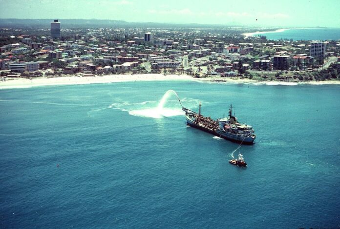
The Sir Thomas Hiley in action at Noosa National Park in 1988. Picture: Port of Brisbane.
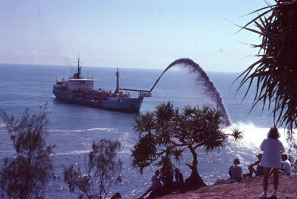
The Sir Thomas Hiley in operation off the coast of Bribie Island in 1997. Picture: Port of Brisbane.
I can see my old house in that photo!
Solid day at Woorim hey?
It's breaking more than a metre off the sand so it must be surfable.
Haha, gave me a chuckle.
Ha.
So after lots of pressure, council have apparently decided to do the bleeding obvious and dredge from the Mooloolah river mouth instead of the spitfire channel...
From the below fb link:
"**** Update 1pm Monday > council have looked into our suggestions & we’re very happy to say they are now going to be using sand dredged from the harbour mouth to replenish beaches & it will be deposited north of cheesecakes giving beaches North Mbar, Alex & Maroochydore the opportunity to see more sand make its way onto the beaches. "
https://fb.watch/g_ufp8ILUg/
So that was 2 days ago, I wonder when that starts. I was down the other end today and watched it head South past Moffs, assumedly (is that a word) on it's way to Spitfire.
***25th, thanks surfiebum
From the 25th onwards
The dredge looks like it has been doing Brissy river and Mud Island lately.
Vessel tracker for those interested in its movements.
https://www.marinetraffic.com/en/ais/home/shipid:695169/zoom:13 (hit "past track" for voyage details)
Sand dumping trial questioned amid plea for replenishment at neighbouring beach

https://www.sunshinecoastnews.com.au/2022/11/29/maroochydore-sand-alexan...
Modified plan: hopes dredging trial will improve safety at Mooloolaba Harbour entrance
https://www.sunshinecoastnews.com.au/2022/11/25/mooloolaba-harbour-dredg...
https://www.sunshinecoast.qld.gov.au/Council/Planning-and-Projects/Infra...
Overview : [Click] FAQ [ 202KB] > ( Is the Sand Dirty or Contaminated?)
This was supposed to be a real simple quest...turned into an epic bipolar battle!
SCC : "Sand is taken from Fed/State Enviro approved Source!"
"The sand will be assessed as suitable for Offshore Placement by State EPA during Approval Process!"
Q: Why are they assessing Dredge Spoil Contamination during & not prior to Rainbow delivery?
Locals Claim : Dredge Spoils are Contaminated Heavy Metal Sludge from Shipping Channel!"
This requires Background Research on POB Maintenance Dredging to investigate Toxic Dredge Spoils.
Q: Is this even possible to research in Qld...tbb very much doubts such...
A: Yes! But the answer involves whole SEQ Resource Players & Industrialized Politics!
That's right...we gotta go round the Block & then again & under here & over there & back again!
Intro to The Bay
Ocean side is 120k Pleistocene (Analogous) or longshore or Sea Level in this case ...if you like!
Bay side is 7k Holocene (Delta) as in multiple river > Bay Scoured drop off Tidal Banks.
Not too hard to imagine more contaminants channeled & butted against inside of Sand bank
Modern Ships need 2.4m draft to seabed of 15m deep channel > Submarines need 20-25m
Could Toxic waste come from Ships!
Fed Bio Security now forbid Ballast exchange in protected Zones.
tbb understands some players like Home Port operators or Cruise lines may receive exemption!
News has often exampled Cruise lines hosing off any virus ya like into Port waters...no worries!
Let's say a few drums go overboard every now & then & possibly outta sight upon leaving the Bay.
Doubt if this is a Major source of Contamination in a Marine Park...(Too obvious!)
Each Larger Flooding Event impacts on Moreton Bay & Shipping Channels with more highly Toxic Silt.
Every Govt / Industry is to blame & all suffer more so each time.
Most of the Silt comes from Lockyer Valley Farm Belt & Dam Releases
1.4m square metres of this silt needs to be cleared from Bne Shipping Channels each Year.
https://www.brisbanetimes.com.au/national/queensland/brisbanes-oil-suppl...
Hence POB extend Powers from Sunny Coast > Dams > Crop Lands ( POB Boss all committees )
They even pay to mitigate up river erosion...to keep SEQ Trade Route open to the World
Wivenhoe Dam Overflow releases 60,000 Tonne / day of Sediment into the Brisbane River.
2012 Campbell Newman reversed Tree Clearing Laws resulting in 3x 300k/H loss of SEQ vegetation!
Moreton Bay / 15m deep Spitfire Channel lies in the Benthic Zone (2002 Test Example)
Fine Sand Content 6m 100% > 8m 80% >10m 50% >12m 30% > 15m 20% > 17m 10%
Correct! Only 10% of Current 15-16m Spit Fire Channel Spoils is Sand!
90% is Broken Shells / Grit / Rubble / Clay / Red Algae (Mud is now #1 M Bay Sediment)
Just this Spoil Content alone could blind or foul lungs of someone close to the Rainbow Spray.
More closely resembles blue sky mining than dredging.
But we're after the real mucky gross unhealthy Spoils...we gotta dig deeper!
Biblical Moreton Bay
Flooding & Polluting Events 1974 / *2009 Mass Oil Spill / 2011 / 2013 / 2017 PFAS / 2022
Tests 'mg/kg' (2002 Spitfire Channel > 2011 (Post Flood) Deception Bay) > Raw Sewage! (General)
'Raw sewage' results are included to test if overflows are a prime source of contamination.
These are the only nearest Tests for time & place...but they do reflect Epic Event Contamination!
Cadmium .01 > .01 > 7.4 (Don't freak out > Larger measure > as they're Raw Sewage)
Arsenic .23 > 3 > 18
Lead .79 > 3 > 202
Zinc 1.2 > 5 > 1,985
Chromium 1.8 > 8 > 314
Mercury .01 > n/a > 6 > (n/a > Ultra High Mercury on Deception Bay Map...Here)
Read the Deception Bay Chapter for Severe Mercury Risk to ecology in these waters! (Massive!)
https://moretonbayfoundation.org/articles/trace-metal-contamination-and-...
+ 2002 Note Author tries to wash over 2009 / 2011 by claiming tides will sort it.
Only the Deception Bay Tests clearly state Severe Toxicity just nearby then 5x bigger 2022 Eco event!
https://eisdocs.dsdip.qld.gov.au/Sunshine%20Coast%20Airport%20Expansion/...
Sewage Mercury is ultra low by Comparison > least contributes to D Bay record Mercury Reading
So what's going on here is something much larger than sewage overflow (Correct!)
2002 Studies swear Pollution hugged the CBD River Mouth not North - but Epic Floods are expanding.
We're seeing Massive Flood Headwater Frontline Contaminants further out from City each time.
Mud or Pesticide Top soil is spreading at alarming rates...
eg: 1970 400sq/km > *2011 (50sq/km/event) > 2016 (800sq/km) > *2022 (5x 2011 = 250sq/km event)
Current Mud Total = Approx 1,100sq/km
*Epic 2011 Flood Takes around 7 years for seagrass to recover
https://www.uq.edu.au/news/article/2011/01/uq-experts-map-moreton-bay
*Epic 2011 Flood Takes 920 Dredge moves over 20 weeks to clear Shipping channels
Heavy Metals > Mercury
Dams (up to 30 y/o) Hydro/Variant up/down Dam levels expose submerged plants producing Mercury
https://m.facebook.com/abcinbrisbane/photos/%EF%B8%8Fdont-eat-fish-caugh...
GC Hinze Dam bans swimming / Dogs / Ban on eating Fish > (Higher than acceptable Mercury!)
https://www.facebook.com/7NEWSGoldCoast/videos/seq-water-warns-hinze-dam...
https://www.seqwater.com.au/alert/catch-and-release-only-hinze-dam
Wyaralong Dam > BYO Water / Bans on Swimming / Fishing License
Choose yer Fav Culprit for Massive Severe Mercury Risk near Bay Entrance...
New/Up Graded/Hydro Dams can flush excess waves of Mercury as far as outer banks!
Sewage Overflow > Shuts Waterways for 3 days > Needing all plants for a Higher Mercury deposit.
Lockyer Fertilizer + 75% runoff > like sewage ticks all same contaminants with massive silt reach.
Grain Port Loading / Transit may require watering or run off process > Toxic residue!
Shipping Anti Fouling agents contain High mercury & is nearest to Crime scene & was associated!
Rocklea / Oxley Industry is also associated with high mercury run off even without floods.
Airport 22,000 L - PFAS Leaked massive Mercury / same contaminants upon Moreton Bay
+
Pacific Adventurer Moreton Oil Spill 2009 (Again...this is a real Sleeper!) Shh!
https://www.rpsgroup.com/projects/pacific-adventurer-oil-spill/
Massive Clean Up (Salute!) 270 Tonne Oil Spill + 31 Ammonia Nitrate Containers
General review of Oil Spill...(Not This one!)
*10% of Oil sinks at time of incident
* Seabed Oil amounts to 2/3 of what Locals see & cleaned represents 1/3 of Oil spill)
*1 year after Spill the oil sinks to the seabed
* Any Flood silt encases the oil & weighs it down to the seafloor & smothers it!
*10 years on lives in livers of Fish & Drops to Ocean Floor via Poop / Plankton
*10 years on represents as 10x higher levels than previous.
*Takes 50-100 years to fully recover
Summary (Parts 1 & 2)
Moreton Bay Dredge Spoils are contracted to SEQ Builders + Piped to Port > Airports.(Expansions)
These Spoils are approved under pre multi Eco disasters 2002 EPA Testing...
Should post multi epic disaster period recent Testing find Severe Risk to Ecology...(As reported!)
Then not one Union could force their Truckies to pick up a load of Toxic filth at Port of Bne.
Therefore the Port of Bne needs an Offshore dumping Ground off some eroding shoreline.
Port of Bne had a perfect Beach in mind!
( Record ) Rain > Locker Valley Run Off > Dam Releases > Sewage > Silting > OIL > PFAS > Contamination.
No Spitfire Channel Contaminants have been Measured since 2002 ( Pre worst ever Epic Toxic Eco Disasters)
Project Team say they'll monitor Contaminants during Dredging .
21st Nov 2022
Locals say no need...Yer not dropping more Toxic Pay Loads onto SEQ #1 recreation beach!
That be how the Govt ran a mile when locals shirt fronted them.
No way do they want to test & stick a Toxic label on POB merch that they can't move!
Not being up for the fight have pulled back on Judge Sludge!
Gotta find another sucker...
Sunny crew might wanna chip in for some extra pipes to prop up the Flood Plain Ranch?
Bonus Research Article : "Historical Changes of the Lower Brisbane River"
Dredging / Flood - Mitigation History...(Happy to Share!)
https://moretonbayfoundation.org/articles/historical-change-in-the-lower...
----------
Two popular Sunshine Coast beaches are set to reinforced with sand from the Maroochy River. Alexandra Headland and Maroochydore beaches will be replenished during the next few months, to provide a buffer against erosion.
https://www.sunshinecoastnews.com.au/2023/05/02/beaches-buffer-extra-san...
----------
----------
A 'quick way to place a lot of sand on the beach': technique could be utilised after successful trial.
https://www.sunshinecoastnews.com.au/2023/06/13/beaches-boost-replenishm...
Beach surveys: Hydrographic surveys and cameras monitored sand movement since the trial finished. Monthly topographic (upper beach) survey results show there was a net increase of 34,170m3 of sand in the upper beach profile along Maroochydore Beach from December 2022 to April 2023.
Surf amenity: A study via UniSC has closely watched the impacts to surf amenity and the results were inconclusive – neither positive nor negative.
----------
Surf Monitoring Report
https://hdp-au-prod-app-suncst-haveyoursay-files.s3.ap-southeast-2.amazo...
Researchers made umpteen mentions of Trees interfering with nearshore Surf data.
Hardly be bothered when Tests span 1hr pre & 1hr post nourishment
tbb thinks this was the main purpose of the Study...see below!
Waves (Pre) 15 Nov 2022 > (Post) 24 Nov 2022
Tide Range : Incoming 1.3m > Outgoing 1.3m
Highest Swell 0.7m @ 9sec > 0.5m @ 10sec
Wave Duration (sec) L 4.1 / R 4 > L 5 / R 4.5
Avg Length (m) L 15 / R 14 > L 18 / R 16
Avg Speed (m/s) L 4 / R4 > L 4 / R 4
"More broken waves were recorded !!"
"This coarser grain sand stands up steeper waves in the swash zone increasing wave reflection!"
Now tbb did earlier suggest that Heavy dredged Sand would form Heavier Slabs...seems obvious!
The photos pointed to increased noticeable backwash in the swash zone...(middle break)
However!
Pre Test data recorded an incoming tide.
Crew will note that said image was observed on the back of a high...(Backwash Hour)
Closer view can correspond backwash with tidal breach upon beach...all very natural, not suss!
Conclusion & Final Recommendation (This is the bit tbb thinks locals should rethink!)
Conclusion : " Comparisons using the WPT metrics were not overly insightful due to (Obstruction to pre-sand nourishment field of view by trees!")
Final Recommendation
"More temporal data (Without Tree Obstructions) would be required to detect subtle differences in surf amenity. This could be achieved with a (Permanent Beach Camera) at a higher elevation above 22m (Without Tree Obstructions) and server based WPT processing."
Repeated calls for trees to be removed sounds counterproductive in the fight against Seachange!
tbb wondered if this was necessary or even if there is a hidden agenda driving this study.
Google Earth can reveal that trees need not be removed if Cams were mounted atop Beachfront Towers.
So why can the study team only afford 2 hrs on monitoring the #1 Mission...no one thinks that's strange!
And why did the Council direct them to use Levels 6/7 of a 12 story building for #1 Sea rise Study?
Then go on & on about those annoying trees that threaten Vital Sea Change Studies from these lower apartments!
The Roof top is littered with telco towers so wotz a 2hr beach cam gonna hurt...this is startin' to look & sound suss!
swellnet has nearby Hi-rise roof top cams that sweep respective clear line-up views 24/7.
Doubt if swellnet demanded Sunny Beach trees be removed to monitor lineups.
Can't see why Sunshine Coast Council can't afford a half decent cam view to their line-up for 2 hours.
'Beachfront Towers' roof top grants 40m height looking over trees & directly down onto the Sand Bank!
Consider the Team only used the Cam twice for an hour each time...Manager is hardly gonna object!
Just gets more Rooftop leasing contracts to buy more holidays...
Ok! All can see this on Google but can also clearly see the Mayor's Billboard bossing next door's site!
Put 2+2 together & these nasty Trees blocking Mayor's mates views will soon magically disappear.
Mayor's mate's Tower Site & Beachfront Towers instantly double in Value in fight against rising angry Sea.
Probably get nominated for OBE for donating tree free Cam space that saved the town...Win! Win!
Tip from the Goldie...
If ya see the Mayor's Trailer Billboard bossin' next door on town's #1 Corner then sound the alarm.
Ask!
Aerodrome Road has nice green grass but very sickly scraggly trees..(Almost see-thru they are?).
Contrary to best planning the most crowded largest hi-rises have least & thinnest trees.(All know why!)
Only a committed council effort can coordinate such bountiful ocean vistas for a bank of Hi-rise Views!
Check the up zone on the Mayor's Cnr'...that undoubtedly requires scientific Sea Change Tree Removal!
Now with such damning evidence of Tree clearing one can draw own conclusion to Study's conclusion.
Looks like Sunny Surfers were raw pawns for Mayor's Sea Change Beach Tree Removal Project!
Mayor is Saving the Planet one Penthouse at a time...(Winner) Friends in high places Whiteshoe Award!