The Black Nor'easter: A Historical Study

The synoptic setup forecast to develop in the Tasman Sea this weekend has weather watchers agog. The configuration isn't overly rare, however it's the magnitude of this system – the size of the air masses and the pressure gradient between them – that sets it apart from similar events.
Technically, this type of system is referred to as an anticyclone intensification, and this particular one will result in a sharp jump in wave heights from the east-northeast for the East Coast. To get some further information on the setup Swellnet spoke to Associate Professor Ian Goodwin of the Marine Climate Risk Group at Macquarie University. Goodwin, a surfer from Sydney's northern beaches, worked on these notes with Tom Mortlock and Stu Browning:
This type of anticyclonic intensification produces a strong north-east windfield and east-north east storm waves over the western Tasman Sea. On average they occur about two days a year. The north-east windfield directing warm moist tropical air to the subtropics and mid-latitudes can combine with an upper level cut off low from the Southern Ocean.
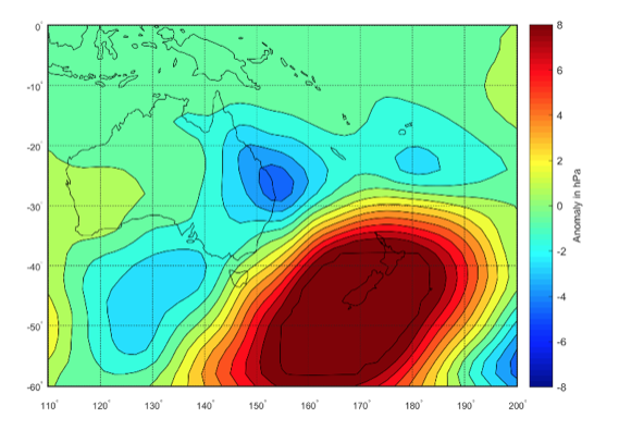
The composite sea level pressure pattern for all east-northeast anticyclone intensification events over the past 30 years is below.
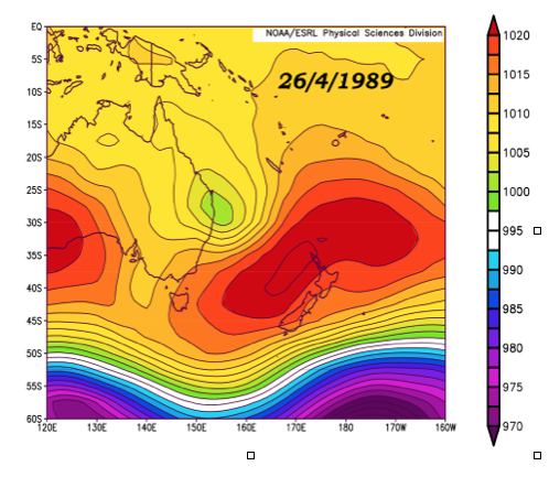
The forecast pattern is most similar to the event of 23 April to 1st May 1989. In that instance the Easterly Trough Low (ETL) formed in the easterly airstream over the Coral Sea and northern Tasman Sea, and was associated with a strong subtropical anticyclone centred on Tasmania and the southern Tasman Sea (see images below).
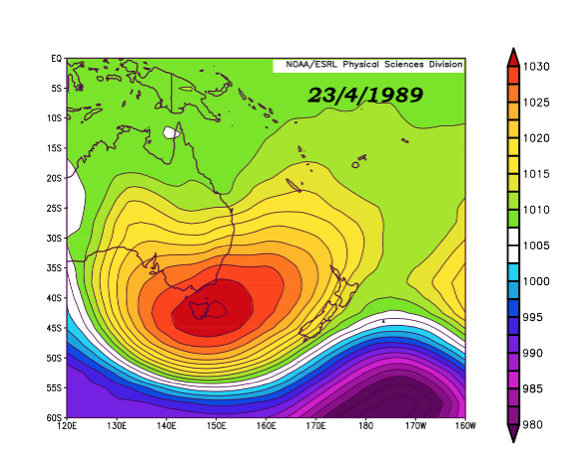
The peak storm wave conditions were observed at Brisbane, reaching wave heights (Hsig) of 6.11 metres and period (Tp) of 9.1 seconds. The duration of the storm wave conditions was 156 hours.
Peak storm wave conditions with wave heights (Hsig) of 5.87 m, 5.64 m, and 5.32 m were observed from the ETL on the 26th April at Byron Bay, Coffs Harbour and Crowdy Head, respectively.
As the ETL tracked south on the 27th and 28th April peak storm wave conditions with wave heights (Hsig) of 4.38 m, 3.72 m, and 3.83 m were observed at Sydney, Port Kembla and Eden, respectively.
Storm damage and coastal erosion from gale-to-storm force winds and high waves was recorded along the northern NSW and southeast Queensland coast. The north-facing coasts, called the southern hooks, of the coastline were most exposed and locations such as Byron Bay experienced severe coastal erosion.
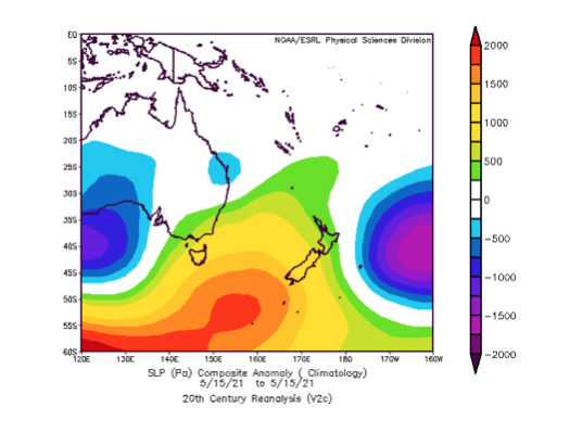
Historically, this type of pattern is referred to as a ‘Black Nor’easter’ and was first recorded during the 1800s. It's possible that a Black Nor’easter was responsible for the grounding of the SS Wollongbar at Byron Bay on the 14th May 1921 when strong north-east gale force winds blew up. See sea level pressure field below.
- Thanks to Associate Professor Ian Goodwin, Tom Mortlock, and Stu Browning of the Marine Climate Risk Group at Macquarie University.
Comments
Be interesting to see what happens to Belongil beach...more fodder for the rock wall debate...
I was gonna check Byron on Mon,Tue when wind swings. Should handle some wide lines. I got a gut feeling for Dixon and some fickle bombies North. Yeew
Why in gods fucking name would you broadcast where you think there will be good waves in the near future ?
Stupidity, ego or loneliness ?
Someone give this arrogant, dumb cunt a hug ASAP.
Its a very dynamic setup what price it doesn't come off as forecast , the Low drops down and then retro grades . ?
Nice story though .
re: Belongil.
I've rarely, if ever seen such a large sand buildup on Belongil from the wreck to the mouth of Belongil creek.
If the storm bars form quickly Sat, the beach might be spared a real gouging.
Bet the land owners are shitting bricks.
you know the rockwall is already there, right?
I would completely expect that with the right timing of tide and swell size and direction, rocks could start to shift.
Would you say it's out of the question FR?
I very much doubt it, but the sand in front of it sure will erode.
but like I said, there is an enormous sand buffer there now.
As the weather starts to turn up...
I doubt it too, I'm just saying that if I lived there, I'd feel a slight puckering.
great short story written by the late great Lester Brien about a couple guys wagering on a house still being there in the morning on the Belongil during the '54 cyclone, where the ocean waves/storm surge rolled down the main street of Byron.
Crazy shit can happen - will this be the one that punches through to the river in Wooli? Probably not but again, would you bet the house on it?
Can you post a link to that story?
Fuck 'em, they can afford it.
Possibly some, but quite a few are probably still in the hands of people who bought many moons ago and don't have the wherewithal to stump up a few $100k or more for repairs.
Try to keep your schadenfreude to a minimum. :- |
one time ne swell was consistent, now its the big deal!
"however it's the magnitude of this system – the size of the air masses and the pressure gradient between them – that sets it apart"
That's it stu, the gradient and length, from that direction, I haven't seen for a long time, if ever.
If it was from the south, meh, fairly strong but not untypical southerly monster, but this is a beast from the north.
Will be interesting to look at south end 'bra come next week.
only time we ever shut the backdoor,was in a black ne,er
I first heard the expression "dirty black nor easter" from Barry V Stark who was a well known knee boarder / fisherman / lure maker / yarn spinner (all lies!) / gem, late of Woombah, who used to knock around with surfings legends of the 60s. RIP Bazza! I got to surf a wonderfully clean and solid NE swell at Coalcliffe Bombie in about 1975 until about 2100 one Friday night under a full moon. It had cleaned up incredibly and was green glass. Could history repeat?
its on the new moon this year, and i hope you got to north's before closing
I think we just crashed in the old slsc clubhouse - coupla hot ones helped. Not too long after that the club house fell into the sea. I saw my mates fall with the kitchen floor and fridge and stove into a very high tide!
"The Black Nor'easter".......
I don't think I've read bullshit like this here since, jeez, the last time I read bullshit like this here.......
Alot more informing than your political waffle Sheepio ;-P
Got a glimpse of the gold on offer on the West coast of your Death Island yet ,Welly ?
Supreme fun .
All work and no play makes Welly a dull boy.
Try hitting up one of the WAPET production boys and get them to take you on a little surfari on your RDO .
Shhhhh !
Haha looks good Blowin.
Out of bounds :(
You read that stuff? A non naturalized kiwi reading threads on Australian politics? Jesus.... You'll be following the wallabees next...... Be careful bruh..
To Martin, I'm deleting your comments (as I also did in the East Coast thread) because that photo doesn't mention the waves name for a reason.
Be cool, man.