Australia Day long weekend forecast

 The Australia Day long weekend is fast approaching and for most this means a whole weekend based around the beach and surf. So how's the forecast shaping up for your region?
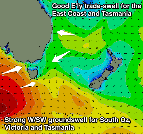
In short every surfable coast is expected to see good waves this weekend with strong groundswells across the southern states and fun levels of easterly trade-swell across the East Coast.
Queensland and Northern NSW:
A sizey trade-swell is due to develop into the second half of this week and the weekend as a tropical depression in the Coral Sea squeezes against a strong high sitting in the Tasman Sea. A broad and strong fetch of E'ly trades will persist through the end of this week before slowly weakening and being directed more towards Southern NSW over the weekend. This should result in the swell being biggest Saturday morning, coming in at 3-5ft before easing a touch but not dropping below 3ft to occasionally 4ft Sunday and Monday.
Conditions look excellent each morning with light local offshore winds before onshore sea breezes develop each afternoon (a stronger south-southeast change is on the cards for Monday afternoon).
Sydney and surrounds:
The Sydney region should see the trade-swell impacting the Northern NSW coast, filter down from the E/NE Friday afternoon, pulsing at various stages through Saturday ahead of a final pulse Monday.
Open beaches should offer 3-4ft waves through the whole weekend, ebbing and pulsing at times. Expect a touch less size across the Hunter region Saturday before the swell straightens more out of the E as the weekend progresses.
Conditions both Saturday and Sunday mornings are looking good with variable tending light offshore winds expected, while a gusty southerly change Monday will limit the best conditions to southern corners.
Victoria:
Moving to the southern states, and for the second weekend in a row, Victoria should see great waves across various coasts.
A couple of vigorous cold fronts will fire up under the influence of the Long Wave Trough, delivering a medium-large sized W/SW groundswell for Saturday followed by secondary pulses through Sunday and Monday.
The Surf Coast should come in at 3-5ft Saturday with 6-8ft sets on the Mornington Peninsula, dropping back a touch into Sunday but steadying through Monday.
Winds are a little dicey Saturday and likely to be light from the east ahead of south-east sea breezes, but Sunday looks great on the Surf Coast with a fresh north-west offshore ahead of a late afternoon south-west change. Monday only looks to offer a short window of workable waves around Torquay with an early westerly breeze, while everywhere else will be poor with an onshore south-west wind.
South Australia:
The same frontal progression generating Victoria's swell should also generate strong SW and S/SW groundswells for South Australia Saturday through Monday respectively. Conditions will be a bit of an issued though with Saturday morning being the cleanest with a morning west-northwest breeze before a south-west change moves through.
Sunday may see an early westerly breeze around Victor Harbor favouring Chiton Rocks and Middleton before a stronger onshore change pushes through before lunch. Monday will be poor with onshore winds all day across the South Coast, although the Mid Coast will be clean and fun, easing from the 1-2ft range.
Western Australia:
The frontal systems firing up towards South Australia and Victoria will only form late in West Oz's swell window resulting in a reduced swell potential and from a less favourable S/SW direction.
Winds are also looking a little dicey on Saturday morning when the surf will be largest (4-6ft South West, 1-2ft Perth, 3-4ft Gero) with S/SE breezes due across most locations through the morning, besides Perth which should offer a SE breeze.
Sunday and Monday look much better for exposed breaks open to the swell with morning offshore E/SE breezes as the swell slowly drops away, becoming small into Monday.
Tasmania:
Both the South Arm and East Coast are expected to offer good waves over the weekend. The South Arm will see the strong W/SW groundswell impacting Vicco pushing in at the same time but from an even more acute westerly direction. Clifton should see 3ft sets Saturday and Sunday morning with favourable winds each morning, while Monday looks poor with a fresh to strong onshore wind and building windswell.
The East Coast should see the trade-swell from the Tasman Sea arriving from the NE Saturday, coming in at 3ft to occasionally 4ft across north-east facing beaches before easing back a touch through Sunday afternoon. Another longer-range and smaller pulse is due Monday afternoon, mixed in with building levels of southerly swell, both building to 3ft on the sets after lunch. Southern corners will be cleanest though with fresh but easing south-westerly breezes. //CRAIG BROKENSHA
Comments
Thanks Craig. Cheers
Hey Craig, the PT. Nepean buoy just fired off a 28 sec period, WTF?
That'd be an anomoly. Buoy data is unchecked (ie no QC on live data) so I'd be very skeptical that it was a real value.
So what did you guys make of Saturday's pulse and the almost unheralded Sunday evening swell.
Both days had the swellnet observed reports around the 2' mark (in the morning), but it pulsed on Saturday although I didn't witness it, just heard about it, but Sunday evening was 4-5 ft plus, a serious pump in the swell in the evening before the southerly hit. Can't explain it by tide as it was going out to low at that stage, and really hadn't expected it after the low had presented well under expectations on Wednesday to Friday.
Appreciate your hindcasts.
BF, not sure what coast you're on (Cronulla or Cenny? I can't remember) but we've discussed the wild variations of Saturday's waves in the comments here. In short, I don't have an explanation, as it was 3-5ft and pumping all day Saturday on the Northern Beaches. For some reason Cronulla started off small, but pulsed to 3-5ft around lunchtime, however the Illawarra remained well below forecast expectations all day.
As for Sunday's late pulse you observed, in last Wednesday's notes I wrote (for Sunday):
"Sunday morning will probably see smaller surf as the E/NE swell fades, however this low is expected to track slowly southwards through Thursday and Friday before re-intensifying in the central Tasman Sea early Saturday, generating a fresh round of solid E/NE swell for the southern NSW coast.
This new energy is currently expected to peak early Monday, but we should start to see a steady upwards trend through Sunday afternoon. The biggest waves will occur in the Far South (as that’s where the fetch will be primarily aimed) but in any case I still think we’re likely to see a fresh shot of E/NE swell across Sydney, Hunter and Illawarra coasts somewhere between 3ft and maybe 5ft if we're lucky.
Let’s see how Friday’s model runs pan out as it’s quite a tricky system that could swing one way or the other over the next few days.
As for Sunday’s winds: a gusty southerly change is due into the South Coast in the afternoon (and into Sydney in the evening) but NW winds will precede it. So conditions should be great for most coasts."
In Friday's updated notes, I pulled back the timing of Sunday's late E/NE swell (which ended up being E'ly in direction) as the low seemed to be slightly slowed in the model runs, which gave me reason to think that the swell would arrive just after dark. I wrote:
"In Wednesday’s notes I discussed a possible re-intensification of the low in the central Tasman Sea on Saturday, leading to a potential pulse from the east late Sunday. This development looks like it’ll still happen however the timeline has been pushed back a half day until early Monday."
I surfed late Sunday afternoon (Northern Beaches) and it did seem a little bigger than the early session, but a smaller in comparison to Saturday - it was mainly 2-3ft but a couple of sneaky 4ft sets did push through.
So, based on all of this - I should have left Wednesday's forecast for a late pulse where it was!
Thanks Ben,
Seriously, it's been so funky lately, swells not coming when I thought they should have, and then Saturday but particularly Sunday evening just stunned me, it was pretty amazing.
Local conditions maybe, bathymetry. I don't know. I thought the south coast may pick up more swell as the charts seemed to indicate that there would be more swell directed their way. Friday was particularly disappointing, and then it all seemed to happen sometime Saturday, but it also had a pulse aspect to it, so not so much in the morning and then later easily twice as big.
As for where I was, this was Maroubra and I paddled out at the north end Sunday late, around 6.30 pm. It wasn't just the odd one, it was regular and coming through.
Of course the southerly kicked in about 30 minutes after I paddled out, and the paddle in around the rocks and the rip was a little hairy.