Buoys Follow One Direction

How much does the swell direction influence the surf at your local?
For surfers on the East Coast of Australia, swells arrive from a wide range of directions depending on their source; anywhere from the north-northeast to the south-southwest.
These directional changes can result in large waves at one location and tiny waves at another - on the same day - depending on each beach's exposure to the swell energy.
But along the southern coastline of Australia there is a much smaller range of swell directions, owing to the source and track of swell producing weather systems - usually anywhere from the west to the south. Additionally, the extremes of this boundary (west swells or south swells) are less common than prevailing south-westerly swells.
Victoria's Surf Coast is uniquely positioned with a broad swell window to the southwest, however incoming swells are refracted as they round Cape Otway. This narrows the apparent swell direction at the coast, so when viewed from shore the majority of swells appear to arrive from the south (give or take a few degrees).
So how can you tell if there's a westerly swell or a southerly swell running through Bass Strait if they all appear to be arriving from a similar direction at the coast?
On the East Coast of Australia, you can check the live data from any one of a number of directional wave buoys between Mooloolaba and Eden.
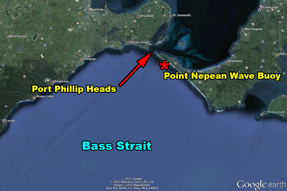
However, buoy data is unfortunately quite limited along the southern Australian coastline, with one buoy each for South Australia, Victoria and Tasmania. And of these three buoys, only one - Victoria's Point Nepean buoy - records swell direction. This buoy is located off Portsea Back Beach, near the western end of the Mornington Peninsula and is a useful tool for remotely confirming the arrival of Southern Ocean swells, and monitoring their trends along central Victorian beaches.
What's unusual about the Point Nepean buoy is that its directional readings are somewhat misleading. And there's an interesting reason why this is the case.

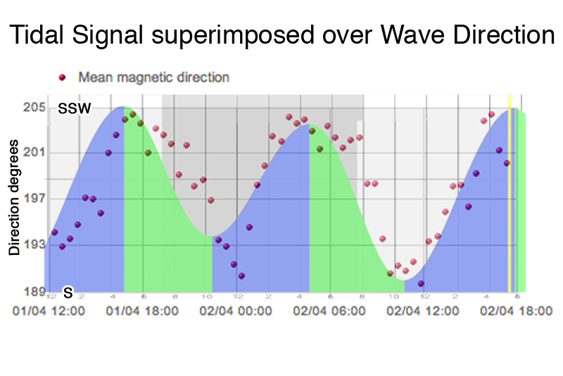
See the image to the left. This is a snapshot of the wave direction data from Point Nepean, taken on the final day of this year's Rip Curl Pro. Interestingly, it shows the swell direction swinging between 205 degrees (SSW) and 190 degrees (S) approximately every six hours.
At any other coastal location, a periodical oscillation in swell direction such as this would be considered abnormal.
But at Point Nepean there are a number of environmental factors that have an influence on incoming swells. After (somewhat crudely) superimposing tidal data from Port Phillip Heads over the direction data, it became clear that the two datasets are almost perfectly in sync with each other (see the second attached image).
This poses several questions. Are the strong tidal currents of Port Phillip Heads interfering with the instrumentation on the wave buoy? Or, are the regional tides of Bass Strait influencing the direction of incoming swells?
By isolating the swell direction data at the turn of the high and low tides – commonly referred to as slack water – it would be reasonable to expect very little current at this time, and therefore minimal influence on the directional data.
But, this is not the case. The observations show that the swell direction is always more southerly at the turn of the low, and more westerly at the turn of the high.
Upon further research, it turns out that the unique physical characteristics of Port Phillip Heads delays the timing of slack water by up to three hours, falling almost mid-way between each tidal phase. Therefore, if we look at the directional data during the middle of the tidal cycle, we can observe a consistent reading from approximately 198 degrees (S/SW). This would appear to be the 'true' swell direction in northern Bass Strait.
We've spoken to the Port of Melbourne (who own the buoy) as well as a number of coastal engineers, but no-one was able to validate this rough theory before the article went to print.
However, the general consensus was that the buoy instrumentation is accurately recording the environmental swell direction, so any unusual changes in swell direction are probably related to currents, rips and eddies associated with large daily tidal movements through Bass Strait and Port Phillip Heads.
There are other factors that can result in erroneous buoy direction data, but we'll leave them for another article. In the meantime, if you regularly use the Point Nepean buoy data, it's always worth looking for abnormal trends before making a decision on where to surf. //CRAIG BROKENSHA with BEN MATSON Link: Point Nepean wave buoy
Comments
Your note about the slack tide is a few hours after stated slack is well known to those who surf Quarra and your right about swell direction never changing much on the Victorian Coast. This is even more apparent on the Mornington Peninsula. Rarely do we get anything it seems but sw swell. Over summer we got one from 180º (according to the dodgy buoy) and it created real peaky 5 foot plus waves - a real rarity for us where the big, long lines never seem to stop.
Yeah, slack tide data at the heads is readily available from the BOM (also known as 'Tidal Stream Predictions'). We just needed to put it into context for non-Victorians who may not have been aware of the disparity.
As for swell directions at central Victorian beaches - we occasionally experience short range SE swells, which are generated locally within Bass Straiy (sometimes producing hollow waves on the Surf Coast reefs due to the angle they arrive at) . But again, so that we didn't lose context, this article referred only to Southern Ocean groundswells.
Interestingly, in my experience these SE swells don't always perform very well on the Peninsula or Island, or even the Bellarine Peninsula, probably because they're all conditioned for long period SW swells.
Jeez Ben,
A couple of wotd's lately and now an article on the joint!!
Peninsula's getting popular!
Good article though, really interesting. Good stuff!
Glad you like the article Goofyfoot - we've tried to keep all of the super techy stuff out of it so that it's an easy read. It's also worth pointing out that a proper investigation into this issue (which I'd love to do) is worthy of a three year PhD, rather than a couple of spare hours on a Thursday afternoon - so we are very limited in what we can achieve.
As for locations - I hear what you're saying, but we haven't named anything.. sure, it's a fine line to tread but I'd like to think that we're doing it as responsibly as we can.
Yeah it's great to read about stuff that concerns your local area.
As for the wotd's, I was just shit stirring, you have been discreet. But it's such a good wave, can't blame a lot of people for wanting to surf it.
Keep up the good work
Thanks GF. Got a few more articles along these lines coming up for the Vicco region over the coming months. It's a lot of fun researching 'em. And creating ridiculous titles for 'em too.
Great article. Currents can turn a wave a bit like refraction over the sea bed, but I've never seen it so consistently in tidal currents before. its common to see waves slow and stand up as they go into an entrance on an ebb tide - so applying the same logic the waves should be turned to the right on the ebb tide out of the bay and vice versa. That fits with your overplot. the tide gauge must be inside the harbour?
Amazing that everything is just right to see that effect - one swell direction, strong and well defined current, the buoy in just the right place.
OMG I love that spot too, but not as much as i love Harry from One Direction!
Now you guys look at this .
No-one wanted to talk about this ' cept ol' Brute . about a year ago .
It would be interesting to see a directional buoy on the mirror opposite western outside . and see the
complete opposite effect . ?!
Only Problem is the RIP doesn't run straight out . And actually angles back towards Portsea side .
The other spanner in the works is the east to west tidal bulge of outside in Bass Strait . Which is essentuated near the top of the Strait at spots near the Bays ( x2 )......
BTW . the roughly 3 hr delay is caused by water building up in Corio bay ( at the western end of PPB ) eventually the tidal forces give way and the Bulge starts flooding back to the entrance at a quick pace .
At a guess ( i'm sure there's ways of calculating [ using the flow speed over volume ] to detect accurately .
but at certain times of the year and day the MSL between inside and outside ( as little as 3-4 kms apart ) could be in theory s much as 40-50 cm's different in height .
If anyone has the best first hand Knowledge it would be ' The Hills ' of MP . Goodluck getting any info tho'.
Gents, thanks for a very interesting article.
However, I really get stuck on the issue of publication of what old dinosaurs like me consider to be the trade secrets of the game. With the water getting more and more crowded, surely the aim should be to reward those interested to seek information and leave those wishing to be spoon-fed to sleep in? If the buoy is giving erroneous readings, then why not let those willing to put in the time and correlate buoy readings with observations enjoy the fruits of their labour?
Of course, I would prefer to see a return to the art of weather map reading, but here I am sitting online checking a myriad buoys, charts and whatever else I can get my eyes on to make sure it's worth getting up and/or planning my next few days. Gotcha, you may say. But please consider for whose benefit some information is published. Often I can't really tell if its for the author or the reader.
I know a stack of crew on the surf coast who don't know the buoy exists, let alone how to interpret it. And why would they generally bother given they are so comprehensively spoon fed the approaching conditions?
Is it not worth encouraging those with the interest to earn the stripes, rather than educate the masses? The only possible outcome of providing easy access to too much information is further increases in crowding and at a rate that challenges the regulars to adapt. If it were about safety, environment, surf etiquette or some other noble pursuit it would be a different debate, but its simply about promoting better understanding of the vagaries of swell direction - where is the public interest angle on that?
You blokes have a great responsibility to use your power wisely, so for the sake of all of us, please think twice a little more often before posting info on trade secrets.
Cheers.
Yeah Southey, I remember someone bringing it up sometime last year but couldn't remember who.
And Bmod, the tidal gauge is right at the entrance to Port Phillip Bay at Point Lonsdale.
And actually when the tide is flooding Port Phillip Bay the direction is swinging more SSW compared to S and hence to the right, while on the outgoing tide the swell direction is swinging more S compared to SSW and hence to the left (opposite to your thoughts? and what would seem logical).
It's quite hard to visualise why it's tending each way at different periods of the tidal cycle.
Also Southey, I would expect the difference to be maybe more than that and up near a metre.
Take for example the 29th of this month. At the heads High Tide peaks at 1.76m, but High Tide in Williamstown (Melbourne) is 0.98m ~3hr later. A difference of 0.78m.
Due to the ~3hr lag the tide would still be rising in the bay at the time the high tide of 1.76m is reached outside, and hence a even larger height difference than 0.78m would theoretically be seen.
Would be great to get some numbers on this though.
Cheers Tango.
But I don't think we're giving anything away at all in this article.
Just bringing to light an interesting and quirky swell direction signature that is fluctuating simultaneously with the tidal signal.
For those that didn't know that the wave buoy existed, they probably wouldn't be interested in it, or understand how to use it effectively anyway. Top hit from Googling "Victorian wave buoy" comes up with the link to Point Nepean, so it's no real secret for those who want to look into the local surf conditions a little deeper.
If you think of Bass Straight as a big bay it's easy to imagine how the swell alters direction.
As the swell wraps around Cape Otway the swell energy fills up the Bay (Bass Straight) As the energy impacts the out-going tide it slows down the Cape Otway swell refraction, hence making the swell angel change more southerly.
As the tide floods in, it allows the SW swell to refract around Cape Otway more than the out-going, making the swell more Westerly.
If you surf the West Coast enough I'll know that out-going is usally better. My guess is the swell energy in the middle of Bass Straight slows down, turns more southerly and allows the West Coast breaks grab more of the swell energy.
Just my opinion..... Probably get chastise for thinking !
tango ,
I'm pretty sure the guys your worried about . ( the instant answer generation ) are probably too lazy to read past the first comment .
And ontop of all this unless your clued into anything to do with this ( ie ; already asking thses type of questions or seeking knowledge ) will any of the above . make sense to .
As i discussed last year . As the tide starts rising in Western Bass strait , the bulge and a slight surface motion moves towards the East then slows nearing high tide . This on direct SW facing coasts within the strait gives a strengthening of swell size and regularity , but maintains more of that SW component that sees not as much refraction from the bathymetry 5-10kms sth of C Otway . So S, SSE and SE facing shorelines miss on this energy increase ( or lack of resistance ) on the rising tide . And oppposite as such on "outgoing" see better conditions or a more S direction as those " shallower " waters close to C Otway have a East to west current closer to shore that inturn refracts the swell harder coming into the strait . Which sees better swell conditions on the West Coast .
Now i do on purpose , make this a little " vague " . Which clarifies that I'm not " feeding the Masses " , and just providing fuel to those that have insight to share to other " thinkers " .
As for the RIP well that probably heightens all this and an offshore Eddy would also confuse things .
Anyone else notice on the larger tidal days , and Indo esque clean conditions , that on the turn of the tide . A: the waves go weird , and B: all sorts of eddy's and surface flows seem to rear their head ( especially in Rippy' Beachbreaks ) . It seems without strong flows in one particular direction or even swell seeing two different direction flows as they make their way through the Strait , thats when it gets all " Twilight zone " .
Of course if you don't fully understand tidal flows , bathymetry , and refractions . this is all German .
Lighten up fella's . its not asif anyones running " guided tours " of wherever ..........
Oh , and Craig . Any boating fisho will tell you about tides and heights and time differences within the bay , you'll find though that the southern half of the bay acts differently to the North . As i said to be truely accurate on heights within 3-4 kms of the rip , you'd have to calculate flow rates on average accross the entrance and cross them over the volume . Too Nerdy for me . BTW anything over 1.6m tide is exceptional , and as mentioned above the choke well inside the bay is a seperate barrier to the flow , and more so incoming .
Back on the Strait thing for others that want to think about something as opposed to receive , people probably need to drop the thoughts of incoming and outgoing , as it should be in this case considered as opposing and following ( swell that is ) . And this isn't strictly governed by the heights but the flows . Pt NP shows this on a different scale and volume , but similarly the entire strait has similar traits !?
Confused .
Good . ;-)
Haha Southy I think my brain just exploded reading that...
interesting article,and now to try and decypher what all that info means??
There is even quite a big difference in the "pull" of the tide on swell directions,but depending on the co-efficient of the tide....so what does it all mean for us surfers???
you can actually work out ,after a few years, when the swell will be at its most consistent and biggest.......have been doing this for a couple of years and there seems to be about 13 different swell directions that actually have affects on how good Bells/Winki/rock etc at certain times of the day.....
ya can also ....using the buoys to predict new swells hitting the Surf Coast within about 1/2hr.......
using the knowledge gives ya that edge in when and where ya surf here.....or not!
I bet it felt good when you realised the graphs overlaid.
Next problem.
Interesting observations.
Note that those wave buoy directions are relative to magnetic north, magnetic declineation to true north is about 11deg from memory so mean wave directions are more westerly than indicated by that buoy.
The influence of wave-current refraction on mean wave directions is likely to be more pronounced at this location because the direction-frequency spectra of the incident waves is often very narrow.
I have been skunked a few times with really Westerly Swells at Bells so its fair play Tango your argument, however there is so much to learn in the whole Direction / Bathsymmetry / Period shit that I'm not sure Swellnet are spilling the beans too much. I reckon we are just touching the sides and there are some fascinating articles about Waimea, Mavericks, Jaws on how these spots work with directions and periods. However now I know the angles its another site to bookmark for the next hit and run. On the counter to your argument Brutus nailed the angles in web commentary for Bells, which is an insight shared to thousands but probably only a few picked up on it, so I'm not sure your spoon feeding them. At the end of the day, I have seen Margarets 5-6 times overhead and Bells at 8-10 foot and there is plenty of room in the lineup
There was another buoy in vico that recorded direction, it is now offline .. While it was working i used it to compare it to pt napean , while the two were similar, this one always showed more west bias in direction, but it also showed quite a degree of direction change during the day, it wasnt affected by an enclosed bay rushing in or out on tide changes ..Now either that buoy was being affected by tides, current in bass straight or shock horror the swell direction changes a whole lot more than previously thought .. Now with all my 35 years in the water at spot x ,it explained to me some of the reasons why the swell would lull out during a session, when it wasnt just tidal influence especially on a pumping swell that had the indicators going off but the swell refusing to get in, straight after these surfs
i checked the direction on the buoys and confirmed my observations as the swell deviated away from its optimum direction for spot x it stopped breaking, some of the times i observed this happening were on one tide days with almost no tide movement for the whole day..
Where was the other Victorian buoy, strawbs? I've only ever been aware of a couple of wave measuring units west of the Prom - one off Port Campbell and another off Portland for the South-west Coast Wave Monitoring project (although I never saw any live data), and also a wave radar off the Thylacine gas drilling rig (off Cape Otway), which I did have data access for a couple of years.
I have no doubt that the tides affect swell throughout the entire Bass Strait region but this really needs to be researched in more detail. Even better - I'd like to see a wave buoy off the Surf Coast somewhere! Pt Nepean is pretty good for estimating surf size but occasionally swells with a lot of west won't get into Torquay yet they show very strong at the buoy.
Hey Ben, I've got a feeling the location of the buoy off Pt Nepean was moved about 12 months ago.
I reckon it may have been located further out to sea and and south east of the current location.
Part of my thinking here is that I used to use the buoy data to predict swell heights on certain Vicco reefs and about 12 months ago my old rules about wave height and direction went haywire. I went looking and found the buoy was real close to the Heads.
Perhaps you can confirm whether my hunch is right or wrong.
Yes, the buoy has definitely moved several times at least floyd, although its previous position was more north-west of the current position (and not that much further out to sea).
I have spoken to PoM about this in the past but can't find my notes regarding the specific reason for it being moved (however I'm pretty sure it was due to an even stronger influence from the heads, as you suggested).
Sometimes the buoy sits underwater during very strong currents/tidal phases which obviously has a bearing on the accuracy of the data recorded (in fact, this is not just limited to the Pt Nepean buoy - the Byron Bay buoy also goes underwater when the EAC moves close inshore).
I'll see if we can find out some more info from the PoM regarding where it has previously been located and why they moved it.
Floyds right, I do not rely on the bouy like I used to. Take today, supposed to be bigger than yesterday, but is easily half the size. I've gone back to the old fashioned way, look at the ocean.
Hi Crustt, just because the buoy increased doesn't mean the size at the beach will.
You have to look at the associated period, and with that dropping you can see why it was smaller than you expected.
The same can be said when the swell stays the same but the period kicks up massively. This will result in bigger waves at the beach but isn't shown directly on the buoy.
Craig can u explain that last comment - is that due to the difference between high period groundswell v low period/ windswell?
Also - can anyone tell me if there is a directional buoy for metro perth? I saw some weird waves at my local on the weekend and I'd love to know what was going on
Cheers
Exactly Pensky, a 2.5m swell @ 7 seconds (windswell) will be smaller on the beach than a 2m swell @ 16 seconds (groundswell) simply because of the additional power and strength the higher period swell holds in the water column below.
And here's a link to the Perth and Rottnest Island buoys..
http://www.transport.wa.gov.au/imarine/19146.asp
http://www.transport.wa.gov.au/imarine/19144.asp
Great thanks Craig
Thanks for the excellent article Craig, really interesting to see the overlay of tide on swell direction. Have been looking at the data from the Buoy for years and wondered what may have caused this shift in swell direction. Looking at the tidal overlay and the consistent oscillation every 6 hours it seems clearly a tidal influence.
Looking at the data and questions posed in the article, I think the oscillation is primarily due to regional tides in northern and western Bass Strait influencing the direction of incoming swell, and not due to a localised effect from tidal streams at the Heads. The main reason is because of the 3 hour delay in slack water at the Heads which does not co-incide with Low and High tide – instead it is around mid-tide at the Heads when slack water occurs. So when looking at the overlay graph in the article, slack water/mid tide is between the peaks and troughs when an average swell direction of around 197 is being measured. Slack water signifies the time when the tidal stream essentially reverses direction 180 degrees and goes from ebb to flood or vice versa, as shown in the graph where for example:
• In the ~6-7 hours between 1000 and 1700 (Low to High), tidal stream direction reverses 180 from ebb to flood at ~1330 (slack time) while swell direction changes 192-203 over the same period.
• In the ~6 hours between 440 and 1040 (High to Low), tidal stream direction reverses 180 from flood to ebb at ~715 (slack time) while swell direction changes 202-190.
It doesn’t seem possible that the tidal stream could be the main influence in the steady shift in swell direction that occurs over each 6 hours, when during the same period the tidal stream undergoes a full reversal in direction. If the tidal stream was the main influence, it would be expected that the run of the stream (either ebb or flood) would correlate with the shift in the swell direction. But this is not the case when factoring in the 3 hour delay of slack water at the Heads.
Looking regionally, it is noted that there is little difference in tide times in western and northern Bass Strait compared to Port Phillip Heads. Apollo Bay (Cape Otway) is only 30 minutes earlier whilst King Island is only 20 minutes earlier. There is no difference in tide times at Flinders or Cape Woolamai. So if we were to take the tidal data from any of these locations (if available), the overlay with the swell direction graph should be almost identical to that produced for Port Phillip Heads in the article.
As mentioned in the article and in comments, there are significant tidal streams that run in western Bass Strait, particularly between Cape Otway and King Island, and King Island and Cape Grim (Tas). Details of these tidal currents are difficult to come by, but the Ocean Racing Club of Victoria has published a series of tidal current prediction charts that show approximate indications of these tidal currents in Bass Strait. What the charts show is that the tides in Bass Strait behave in an 'accordion' type dynamic, flooding in from the east between the Prom and NE Tas, and also flooding in from the west between Cape Otway and NW Tas, before ebbing back out in reverse directions. The ridge of the 'accordion' seems to lie along a rough line between Cape Liptrap and Devonport. For Western Bass Strait where SW groundswells approach the Vic coast from, it is apparent that by 1-2 hours after Low tide at the Heads, the flood tide has gathered momentum and streams in to Bass Strait between Cape Otway, King Island and Tasmania in north, east and northeast directions up to High tide. The system then reverses such that by 1-2 hours after High tide, the reverse happens and the tide ebbs back out of western Bass Strait in south, southwest and west directions to Low tide. I think that it is these changes in tidal streams that causes the oscillations in swell direction, with the flood tide shifting the swell from a S to more SSW direction, and vice versa in an ebbing tide. But has to how this mechanism may work am also having trouble visualising.
Cheers
I missed this one, but its a really interesting read being a vicco boy.
Also interesting to read about the tidal influence on swell in bass strait as in my late teens I spent a few years living on the North West coast of Tassie, one of the most fickle coast in Australia most of the time we had to surf onshore wind swells, but the whole coast also has an amazing array of quality reefs, some small pockets or reefs although rare can actually can pick up groundswells that wrap around from open ocean, certain reefs would one hour be flat then suddenly a half foot groundswell would turn into waist to head high sets, mostly with huge lulls, and often disappear as fast as they came.
When i lived there it was back in the day way before surf reports and internet, so had to learn how to read synoptic charts which helped figure it out but it was also obvious there was so many other factors at play and always had the theory that there was a tidal influence, not just at the beach but in bass straight itself that affected things, interesting to read this article/comments, as confirms that as grommets we were on the right track, off course change of swell direction during the day would also have had an effect and swell period.
Craig ,
Check out Sunday's buoy readings .
Nearest the biggest possible astronomical tide , quite a large period west swell ' add to that a strong Northerly . And even the swell size was varying with tide .
But we were also seeing as much as 25 deg variation in swell direction .
Yeah huge variation in direction with the tide, although can't notice any affect on the size? Or are you talking locally where you were?
Today's sharp rise in the swell masks yesterday's swell size variance a little .
When I looked late last night it really appeared to waver in a two nodal pattern . And yes the two extremes were in contrast to the lesser troughs and peaks of the tide . It did also show at the 2-3 spots I witnessed on the surf coast .
Awesome read Craig and Ben, still getting a workout now in April '17. Thank you!