Mix of swells Tuesday; fun NE swell Thursday; dynamic period from the weekend onwards

Sydney, Hunter and Illawarra Surf Forecast by Ben Matson (issued Monday 9th October)
Best Days: Tues: early light winds (except maybe the Hunter) with a peaky mix of SE and S swells. Thurs: fun NE swell with offshore winds. Get in early. Fri: fun small S'ly swell with early light winds.
Recap: Saturday’s short range south swell came up overnight Friday, eased into the early part of Saturday morning before rebuilding mid-morning on Saturday close to forecast expectations, if a little under with sets in the 4-5ft+ range across Sydney’s south facing beaches, and bigger bombs across the Hunter. Size then eased steadily into Sunday with cleaner conditions as winds went light offshore in the morning. Today we’ve seen a strong SE groundswell punch slightly higher than forecast expectations with sets in the 4ft+ range at exposed beaches, and early light NW winds have swung to a NE sea breeze at most coasts except the Hunter, which saw fresh NW winds override the sea breeze effects.
This week (Oct 10 - Oct 13)
Today’s SE swell is already easing and will be a shadow of its former self by Tuesday morning. Set waves will be down to 2-3ft at exposed beaches with a reasonable degree of southerly exposure (a smidge bigger in the Hunter) and it’ll lose another foot or two throughout the day.
A southerly change will clip the coast overnight but it’ll be gone by the morning, leaving winds mainly light and variable (ahead of afternoon sea breezes), perhaps a lingering southerly flow through the Hunter if we’re unlucky. As such, everywhere south of here should see clean conditions for the early session.
A small fetch of SW gales exiting eastern Bass Strait tonight (associated with the change) will generate a small degree of south swell for Tuesday too, but it won’t be any bigger than the pre-existing SE swell and will largely mix in at south facing beaches.
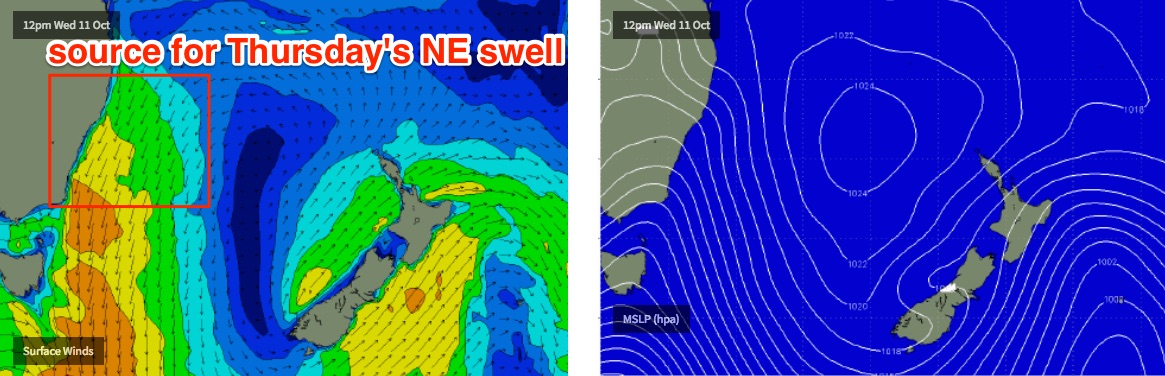
Wednesday looks very ordinary as both the S’ly and SE swells bottom right out, and early light winds swing into a fresh afternoon nor’easter. We’re likely to see plenty of size by the end of the day - perhaps some 2-3ft+ sets at NE facing beaches on dark - but conditions won’t be great with the local breeze.
The good news is that this fetch is expected to reach peak strength around midnight, generating a solid short range NE swell that’ll peak through Thursday morning, just at the same time a front crosses the southern part of the state, swinging winds to a moderate NW breeze ahead of a W/SW flow into the afternoon. This should see punchy 2-3ft+ sets at most open beaches, occasionally 3-4ft at a handful of NE swell magnets, and they’ll be clean under the offshore wind. The South Coast's NE swell magnets will see larger waves due to the longer fetch length.
However, south facing beaches and the northern Hunter coast will be smaller in size due to the swell direction. Size will also trend down throughout the day so surf early for the best waves.
A broad fetch of W/SW gales exiting eastern Bass Strait on Thursday morning (behind the front responsible for the offshore wind change) will kick up a fresh S’ly swell, but I’m not very confident on the timing for now.
Current expectations are that it’ll arrive very late afternoon across the South Coast (into Sydney around dinnertime or later), peaking overnight before easing through Friday morning, which is a shame as it should be worth of 2-3ft sets at south facing beaches at its peak, and up to 3-4ft across the Hunter (this may occur overnight).
Let’s hope the models delay its arrival as Friday morning is shaping up to deliver very clean conditions with light offshore winds.
This weekend (Oct 14 - Oct 15)
A broad, strong Southern Ocean front and low passing south of Tasmania on Thursday night won’t be very well aligned within our swell window, but the strength and breadth of the associated fetch should override some of the directional deficiencies.
As such we should see a couple of small, long period S’ly swells over the weekend, probably contributing somewhere in the 2-3ft range to south facing beaches both days (a little bigger in the Hunter, but much smaller elsewhere due to the direction).
Local conditions look a little suss through with a coastal trough expected to drive easterlies into the Northern NSW coast and this may extended as far south as Sydney or Wollongong. However, the upside of this is that we’ll also see some short range E/NE swell at the same time.
Let’s take a closer look on Wednesday.
Next week (Oct 16 onwards)
Broad easterly winds through the northern Tasman Sea this weekend looks like they’ll anchor in a synoptic pattern for a few days, slowly building short range E/NE swells about Southern NSW early next week.
There’s certainly a lot of potential for strong swell from this pattern but it’s early days, so let’s look into it more comprehensively on Wednesday and Friday.
Comments
Definitely a fair bit bigger than 4ft at south magnets on the south coast this morning, Ben. Absolutely pumping.
How big did it get in your neck of the woods?
Would've been easily 6ft+ on the (inconsistent) bigger sets.
Crikey, really? You *just* down south or *right* down south?
Shoalhaven area.
Some seriously good sand at a few locals for some ne swell yew
Now I know if the north Easter blows for days is pushes the warm water off shore and replaces it with the deep cold water, but how bout straight east? Same effect?
No, because the Ekman Transport is to the left, so an east wind would push the warm water south, basically bringing in more warm water from the north.
Cheers, hopefully some rain comes with this quasi trade wind set up
Amazing to see the water turn green after the upwelling last week and now there are little salps everywhere in the water column.