Unfortunately the outlook for the weekend, and in fact much of next week has taken a turn for the worse. But not because of a lack of swell. More in the Forecaster Notes.
Primary tabs
/reports/forecaster-notes/south-east-queensland-northern-new-south-wales/2020/01/15/significant
thermalben
Wednesday, 15 January 2020
/reports/forecaster-notes/south-east-queensland-northern-new-south-wales/2020/01/13/plenty-swell
thermalben
Monday, 13 January 2020
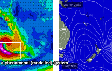
A large tropical cyclone is expected to develop north of Fiji over the coming days (it’s current tagged by JTWC as INVEST 93P) and the models have moved around on its future developments since Fridays notes were issued. More in the Forecaster Notes.
/reports/forecaster-notes/south-east-queensland-northern-new-south-wales/2020/01/10/lengthy-run
thermalben
Friday, 10 January 2020
We’re looking at an extended run of E’ly swell as the trades firm up and broaden through the swell window. More in the Forecaster Notes.
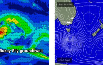
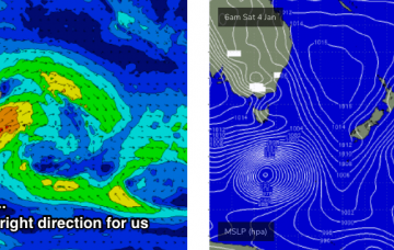
/reports/forecaster-notes/south-east-queensland-northern-new-south-wales/2020/01/08/very-active
thermalben
Wednesday, 8 January 2020
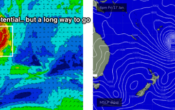
The sheer size, strength and alignment of the fetch is incredible, and the recent model trends are a positive sign at under 4 days out from genesis. More in the Forecaster Notes.
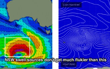
/reports/forecaster-notes/south-east-queensland-northern-new-south-wales/2020/01/06/average-week
thermalben
Monday, 6 January 2020
A rebuilding pair of ridges - one in the central Tasman Sea and another through the Coral Sea - will generate a sustained period of small trade swell for much of the East Coast. More in the Forecaster Notes.
/reports/forecaster-notes/south-east-queensland-northern-new-south-wales/2020/01/03/average-outlook
thermalben
Friday, 3 January 2020
With surf size being a little smaller than expected for the last few days, and the only swell source for the weekend being the tail end of the TC Sansai event, we need to recalibrate our size expectations across the region. More in the Forecaster Notes.
/reports/forecaster-notes/south-east-queensland-northern-new-south-wales/2020/01/01/more-cyclone
thermalben
Wednesday, 1 January 2020
Although wave heights have pulled back a smidge today from yesterday, the good news is that we’re expecting another pulse overnight tonight and into tomorrow. More in the Forecaster Notes.
/reports/forecaster-notes/south-east-queensland-northern-new-south-wales/2019/12/30/plenty-cyclone
thermalben
Monday, 30 December 2019
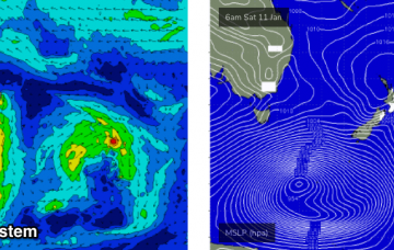
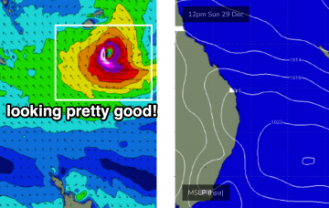
So, with cyclone swell starting to push through the region on schedule, we have to make a call whether to follow model guidance or not. More in the Forecaster Notes.
/reports/forecaster-notes/south-east-queensland-northern-new-south-wales/2019/12/27/great-cyclone
thermalben
Friday, 27 December 2019
Bugger. We’ve got a whole week of northerly winds on the cards, coinciding with an otherwise strong cyclone swell out of the east. But there should be brief windows of opportunity across some coasts. More in the Forecaster Notes.
/reports/forecaster-notes/south-east-queensland-northern-new-south-wales/2019/12/25/patchy-short-term
thermalben
Wednesday, 25 December 2019
The tropical cyclone mentioned in Monday’s and Friday’s notes is still well and truly on the radar. Unfortunately, we don't have the kind of wind forecast you hope will coincide with an easterly groundswell event of this kind. More in the Forecaster Notes.
