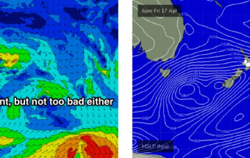
We’ve got a steady supply of building southerly swells on the cards, originating from two seperate fetches contained within one broader system, all associated with an amplifying Long Wave Trough. More in the Forecaster Notes.
Primary tabs
/reports/forecaster-notes/south-east-queensland-northern-new-south-wales/2020/04/17/turning-the
thermalben
Friday, 17 April 2020
/reports/forecaster-notes/south-east-queensland-northern-new-south-wales/2020/04/15/more-swells-out
thermalben
Wednesday, 15 April 2020
Sometime mid-late afternoon, I’m expecting the regional wave buoys (in Northern NSW) to have picked up the leading edge (15+ seconds) of a new SE swell generated by an intense low that formed S/SE of New Zealand on Monday - in actual fact, a merger between the low that generated our current swell, and a new polar low. More in the Forecaster Notes.
/reports/forecaster-notes/south-east-queensland-northern-new-south-wales/2020/04/13/southerly-swells
thermalben
Monday, 13 April 2020
Strong fronts have been pushing through the lower Tasman Sea all weekend, and they’ll provide plenty of south swell for the next few days. More in the Forecaster Notes.
/reports/forecaster-notes/south-east-queensland-northern-new-south-wales/2020/04/10/extended
thermalben
Friday, 10 April 2020
Model guidance remains consistent for a succession of secondary fronts to push through the lower Tasman Sea on Sunday and Monday, generating strong reinforcing southerly swells for Monday, Tuesday and maybe early Wednesday. More in the Forecaster Notes.
/reports/forecaster-notes/south-east-queensland-northern-new-south-wales/2020/04/08/dominant-swell
thermalben
Wednesday, 8 April 2020
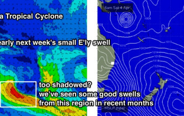
We have some small E’ly swell on the way for SE Qld, and then a run of solid S'ly swell, biggest in Northern NSW. More in the Forecaster Notes.

/reports/forecaster-notes/south-east-queensland-northern-new-south-wales/2020/04/06/coupla-swell
thermalben
Monday, 6 April 2020
We’ve got a couple of source on the cards but nothing overly special. More in the Forecaster Notes.
/reports/forecaster-notes/south-east-queensland-northern-new-south-wales/2020/04/03/extended-run
thermalben
Friday, 3 April 2020
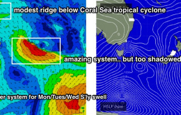
TC Harold is expected to remain behind the New Caledonian swell shadow this weekend, and upon re-entering our swell window on Monday and Tuesday, will likely move too fast to the east, which is a poor storm track for our swell prospects anyway. More in the Forecaster Notes.
/reports/forecaster-notes/south-east-queensland-northern-new-south-wales/2020/04/01/patchy-the-next
thermalben
Wednesday, 1 April 2020
Next week has plenty of swell sources on the cards, though things have changed a little since Monday’s notes were prepared. More in the Forecaster Notes.
/reports/forecaster-notes/south-east-queensland-northern-new-south-wales/2020/03/30/coupla-days-small
thermalben
Monday, 30 March 2020
Model guidance is also suggesting a tropical cyclone may form in the Coral Sea this weekend. More in the Forecaster Notes.
/reports/forecaster-notes/south-east-queensland-northern-new-south-wales/2020/03/27/peaky-mix-swells
thermalben
Friday, 27 March 2020
It will be worth keeping an eye on our far eastern swell window for the long term period. More in the Forecaster Notes.