Several windows of opportunity on the boil
Friday, 24 March 2023
Several windows of opportunity on the boil
Friday, 24 March 2023
Today’s surf will increase more prominently through Saturday towards a peak on Sunday morning.
Today’s surf will increase more prominently through Saturday towards a peak on Sunday morning.
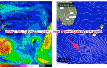
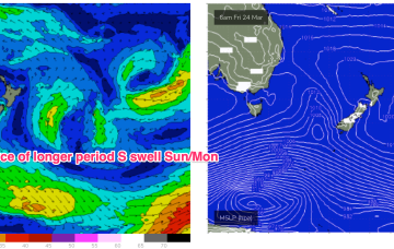
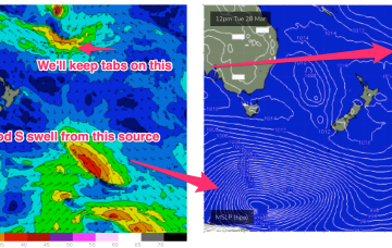
Long period S swells will be the dominant swell trains next week (for NENSW) as a complex deep low traverses the far southern Tasman Sea and becomes slow moving in New Zealand longitudes.
Long period S swells will be the dominant swell trains next week as a series of deep low traverse the far southern Tasman Sea and become slow moving in New Zealand longitudes.
No great change to the slow moving pattern which is seeing a blocking high (1034 HPa) well to the SW of the state maintain a ridge of high-pressure across the SW with an inland trough enhancing ESE-SE winds through the morning. This stuck pattern looks to remain in place right through the end of this week and over the weekend, and even into early next week.
High pressure has now moved into the Tasman, reinforcing tradewinds in the Coral Sea.
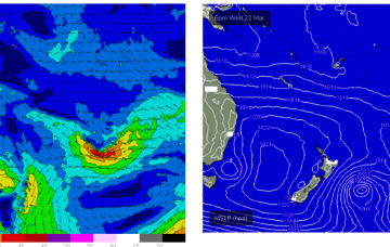
A series of overlapping swell trains will start to filter in on Thursday afternoon, with a gradual increase expected over the coming three days.
In the south a small trough of low pressure off the Gippsland coast is aiding a N-NE flow through temperate NSW with a S’ly change on the radar for tomorrow. The remnants of a low near the South Island are now dissipating after a final flare up yesterday.
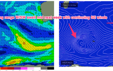
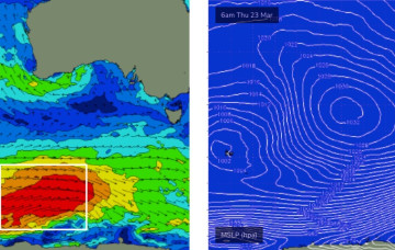
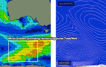
The bulk energy from the upcoming Southern Ocean sequence will build further into Saturday, reaching a peak on Sunday.
Average waves are expected to finish the week though the trend will be up, which is good.
In the Coral Sea a monsoon trough remains active with a persistent but unspectacular trade-wind flow maintaining a small fun E swell signal north from Port Macquarie. The remnants of a low near the South Island are now dissipating after a final flare up yesterday.