Make the most of the coming days
Monday, 4 September 2023
Make the most of the coming days
Monday, 4 September 2023
We've got a flukier forecast period ahead as we transition out of winter into spring.
We've got a flukier forecast period ahead as we transition out of winter into spring.
Easing surf tomorrow ahead of a small, reinforcing SW pulse, then followed by flukey west swell next week.
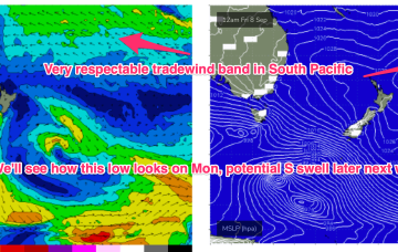
We do have a promising outlook though for mid/late next week as another high in the Tasman, and strong high in the South Pacific set up a long tradewind flow in the South Pacific and a shorter, proximate tradewind flow in the Central Coral Sea.
S swells will be the dominant though easing force in the water through tomorrow, mostly mid period stuff whipped up by a proximate fetch of S-SSW winds generated by a front and trough of low pressure forming in the Tasman with some small longer period swell mixed in.
No great change to the weekend f/cast. S swells will be the dominant force in the water through tomorrow, mostly mid period stuff whipped up by a proximate fetch of S-SSW winds generated by a front and trough of low pressure forming in the Tasman.
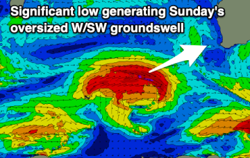
The weekend will be poor with an oversized, building swell, holding Monday morning but only going offshore mid-next week across Perth and Mandurah.
Make the most of the waves in the gulf today as the swell will fade as conditions improve for the South Coast on the weekend. There's a ton of west swell due next week.
No great change to the weekend f/cast. S swells will be the dominant force in the water through tomorrow, mostly mid period stuff whipped up by a proximate fetch of S-SSW winds generated by a front and trough of low pressure forming in the Tasman.
We've got improving conditions that will suit the beaches on the weekend, with moderate sized westerly swells for next week with varying winds.
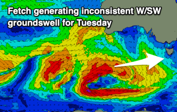
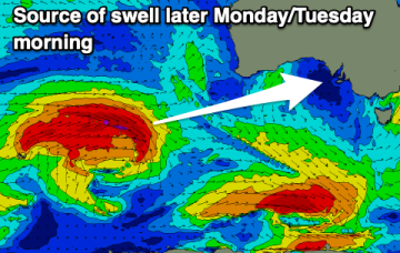
Slow ahead of a good S/SW groundswell episode from Tuesday next week.