Make the most of the coming days

Victorian Surf Forecast by Craig Brokensha (issued Monday 4th September)
Best Days: Tomorrow Surf Coast, Wednesday
Features of the Forecast (tl;dr)
- Inconsistent, moderate sized W/SW groundswell building tomorrow, peaking into the afternoon/evening
- Moderate sized, weaker W/SW swell building later tomorrow, easing Wed
- Early fresh N/NW winds tomorrow, shifting strong W mid-late AM, then W/SW, tending weaker W/NW late
- Easing surf with strengthening N/NW to the west Wed, N all day to the east
- Smaller Thu with early strong N tending N/NE winds, N/NW on dark
- Poor quality, moderate sized S/SW swell Fri with strong S/SW winds
- Weak, easing swell Sat with S/SW tending S winds
- Smaller Sun with lingering SW winds
Recap
Friday's sizey mid-period swell (that improved through the afternoon with abating onshore winds), cleaned up into the weekend across all locations with good sized, easing 3-4ft sets on the Surf Coast magnets Saturday, best through the morning, while the exposed beaches were a solid 5-6ft on the sets.
Yesterday morning was smaller, less consistent and fading further from 2ft to occasionally 3ft on the Surf Coast magnets, 4ft+ to the east with all day offshore winds for the beaches. The swell has bottomed out into this morning with a slow little peeler for the desperate east of Melbourne.

Inconsistent but decent sets in the mix yesterday AM
This week and weekend (Sep 5 - 10)
This morning looks to be the smallest the Victorian region has been in a long, long time.
We've fallen in between swell generating storms as a high followed Thursday and Friday's front, while strengthening northerly winds are developing ahead of a mid-latitude front pushing through the Bight.
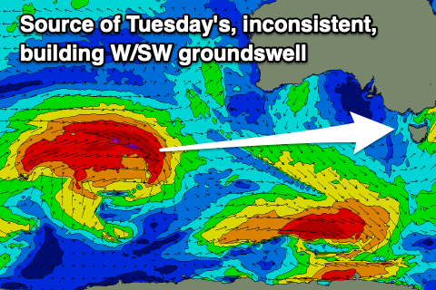
We should the size build back through tomorrow as an inconsistent W/SW groundswell fills in, peaking into the late afternoon/evening. The source of this swell was a strong but distant frontal system developing west of the Heard Island region late last week, pushing east while generating a fetch of gale to near severe-gale W/SW winds.
It weakened on approached to Western Australia on the weekend, with the remnants now moving in from the west towards us but with no additional swell generating properties.
The swell should build to an infrequent 4ft on the Surf Coast magnets through the afternoon, 6ft+ to the east along with early fresh N/NW winds, giving into a strong W'ly change mid-late morning, then W/SW into the afternoon, likely easing and tending back W/NW later. So there'll be a period of average wind affected conditions that should improve later.
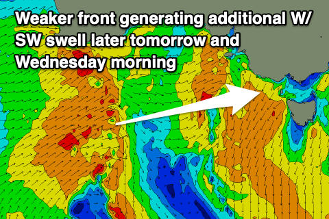
A secondary frontal system that was expected to bring some better sized and more consistent mid-period W/SW swell for Wednesday now looks much weaker.
We'll see this front push through tomorrow with strong W/SW winds projected from under Western Australia, east, and this should maintain surf to 3-4ft on the Surf Coast magnets Wednesday morning, 5-6ft to the east, easing through the day.
Winds on Wednesday look favourable for both regions, strengthen from the N-N/NW on the Surf Coast and N'th to the east, similar Thursday morning with the swell easing from 2ft on the Surf Coast and 3ft to possibly 4ft to the east. Winds look strong from the N'th early Thursday, shifting N/NW into the afternoon and then possibly N/NW late with an approaching trough.
Friday onwards looks generally poor as the trough deepens into a low pressure system while moving east, bringing strong S/SW winds and a rapid jump in low quality, stormy swell.
Easing surf is due on the weekend as the low moves east and weakens with a possible window of W/NW morning winds on the Surf Coast but most likely S/SW winds and weak, easing 3ft sets.
A SW'ly looks to linger on Sunday along with no, new significant swell.
Longer term the outlook remains at contrast to the months just gone with high pressure and no significant swell generating systems in our close to medium-range swell windows.
In our far swell window a significant frontal progression is forecast to develop north-east of the Heard Island region this weekend, generating some inconsistent W/SW groundswell for late next week but we'll have a closer look at this on Wednesday.