Nice swell combo ahead, from the east and south
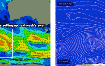
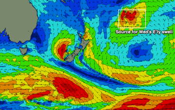
Late afternoon, the leading edge of a new long period S’ly swell will make landfall, though we’re not expecting wave heights to peak until...
An impressive series of stronger, better-aligned followup fronts behind this - from Friday thru’ Monday below the continent - will then generate much better surf for the region.
No major changes to Craig’s notes from Friday - we’ve got a strong SW groundswell inbound tomorrow.
More S groundswell expected next week, with a renewal in S swell Tues from a deep low passing under Tas later Sun into Mon.
The surf and swell keeps on coming with generally favourable winds.
The Indian Ocean is teasing us and making it tricky to pull apart mediocre swell sources.
We’ve still got the intense Tasman low in the picture sending plenty of strong SE swell our way, located now off the west coast of the South Island, with a large slow moving high SW of WA and powerful fronts under the SE of the continent.
We’ve still got an intense Tasman low in the picture sending plenty of swell our way, located now off the west coast of the South Island, with a large slow moving high SW of WA and powerful fronts under the SE of the continent.
The coming days will be great for the South Coast with light winds and good amounts of swell, becoming large one last time early next week.
This morning is great and there are plenty more quality surf days to come west of Melbourne before things start drying up.