Winter flat spell continues through next week
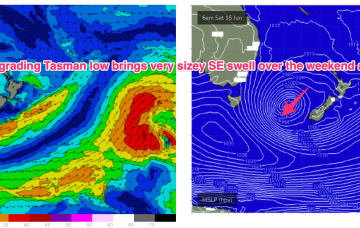
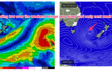
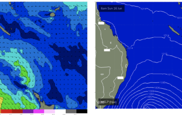
The result will be tiny/flat surf for the CQ coast into the weekend and all of next week under current modelling.
Into the weekend and the low retrogrades back towards Tasmania over the weekend with plenty of size expected from the S/SE-SE.
A deep Tasman Low forming east of us will bring large surf and strong southerly winds.
Following that a secondary front coalesces with the primary front to form a complex Tasman which is expected to occupy the Tasman for a meaningful period of time, even retrograding back towards the East Coast over the weekend. The result will be multiple swell pulses from the S to S/SE (some very significant) right through until mid next week.
We've got a period of more favourable winds and a good westerly swell inbound for Sunday/Monday.
Following that a secondary front coalesces with the primary front to form a complex Tasman low which is expected to occupy the Tasman for a meaningful period of time, even retrograding back towards the East Coast over the weekend.
Better S/SW swell energy should fill in down South as the west swell fades.
We've got better local winds forecast for tomorrow with a good sized S/SW swell, easing Friday. The weekend looks poor while next week will be very slow.
This week looks the most active for swell across all regions.
Thursday is where things really get active. A deep Tasman Low will have been forming from Wednesday onwards, displaying a broad belt of S/SW winds that’ the entire length of the eastern seaboard, from the southern tip of Tasmania up to about Mackay.