No respite in the South West
Western Australian Tasmanian Forecast by Craig Brokensha (issued Monday July 14th)
Best Days: Perth/Mandurah Wednesday morning, Thursday morning and Saturday morning
Features of the Forecast (tl;dr)
- Easing surf tomorrow with strengthening W/NW winds (light E/NE-NE tending NW to the north)
- Large SW groundswell for Wed AM, with a stronger pulse for the PM in the South West
- Strong SW winds Wed, developing S/SE winds to the north shortly after dawn
- XL SW groundswell Thu AM, easing slightly
- Strengthening W/NW winds Thu, (light E/NE-NE tending NW to the north)
- Reinforcing, lower period XL swell Fri. easing over the weekend
- Strong SW winds Fri
- Fresh W/SW tending NW winds Sat, (light E/NE-NE tending NW to the north)
- Strengthening N/NE tending N/NW winds Sun
- Possibly large stormy swell early next week
Recap
Saturday was poor and onshore across all locations, while into yesterday we saw the frontal system linked to a large kick in mid-period swell clearing, leaving offshore winds and lumpy, low period surf to 6ft+ in the South West, 3ft+ Mandurah and 2-3ft Perth.
This morning winds were back into the Margaret River region while Perth and Mandurah both started average at dawn before improving as winds tended more variable.
This week and weekend (Jul 15 - 20)
The coming week will be best across northern regions, with Margaret River seeing persisting onshore winds and large to extra-large surf. Tomorrow will be smaller with early NE winds across Perth/Mandurah, not great.
Looking at the incoming frontal progression, it looks like we’ve fallen somewhere in between EC’s (European model) maxing forecast and GFS’s (American model) slightly more subdued setup.
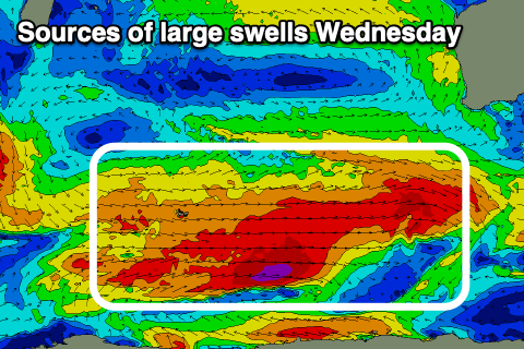
Regardless, we’ve got a significant Southern Ocean frontal progression on the cards, with an initial strong polar low that formed south-east of South Africa moving across the Heard Island region, generating a large, long-period SW groundswell for late Wednesday in the South West, Thursday morning to the north.

Ahead of this though, another moderate to large, more consistent SW groundswell is expected later tomorrow and into Wednesday morning, generated by a low spawning off ahead of the progression as a whole today.
A fetch of gale to severe-gale W/SW winds late in our swell window should provide 8ft+ sets in the South West, 2-3ft Mandurah and 2ft+ Perth. Local winds will be strong from the SW in the South West, with Perth/Mandurah being poor pre-dawn with S/SW winds, easing and tending S/SE shortly thereafter.
The stronger pulse of SW groundswell for later Wednesday should kick to the 12ft range in the South West, while come Thursday morning, an even larger pulse of groundswell is due, generated by a great polar front projecting towards us through tomorrow, passing under us Wednesday.
The South West should come in around 15ft with Mandurah offering 3-5ft waves, 3ft to occasionaly 4ft across Perth.
This won’t be the end of the swell though, with a final slightly weaker and less favourably aimed frontal system providing a large, reinforcing SW groundswell for Friday, likely coming in around a similar size to Thursday morning but with less energy thanks to the lower period.

Looking at the local winds and the South West will unfortunately see strengthening W/NW breezes on Thursday, lighter E/NE-NE tending NW to the north, with strong SW wins due everywhere Friday as the final swell producing front moves through.
The weekend will provide cleaner conditions across Perth/Mandurah as the swell eases thanks to an E/NE-NE tending NW breeze Saturday, persistent W/SW tending NW across the South West.
At this stage the models diverge a little into Sunday but we’re likely to see poor, strong N/NE tending N/NW winds ahead of a strong mid-latitude low forming directly off us, but the models diverge on this solution. More on this next update.

