Large surf but tricky winds early week, with better conditions for the weekend
Western Australian Forecast by Lorena Woortmann (issued Monday May 2nd)
Best Days: Friday and Saturday in Perth and Mandurah with possible early windows for Margs but more so Sunday
Features of the Forecast (tl;dr)
- Large WNW swell tomorrow and Wed
- Tricky winds from W quadrant and the chance of OK windows in the early AM
- Moderate SW pulse for Thurs PM
- Blown out conditions at Margs on Thurs and maybe a SSE window in the AM for Perth and Mandurah
- Improving conditions at Perth and Mandurah from Friday, poor in Margs
- Inconsistent SW swell building through Friday, peaking in the PM and holding Sat AM
- Offshore winds Sat at Perth and Mandurah
- Chance of SSE window Sat AM in Margs
- Pumping on Sunday with a reinforcing groundswell and easterly winds across the coast
- Potential for a large WSW groundswell into early next week
Recap
We had pumping surf on Sunday morning as the winds held from the East early morning, with 6ft+ SW waves at Margs, and clean 2ft+ sets in Perth. Conditions deteriorated through the day as the winds tended NE from late morning.
Today wasn’t as great with the easing groundswell leaving not much around Perth and the NNE winds making it really tricky on the South West, seeing a building wind swell.
This week and weekend (Jun 3 - 8)
As mentioned in Friday's notes, we have a large WNW swell arriving tomorrow generated by the northern flank of a tight low pressure that formed off the coast over the weekend, which had winds up to 50 knots.
This should peak later tonight and Tuesday morning with 8-10ft for Margs, 4-6ft for Mandurah and 3-5ft for Perth, however as the low pressure continues to move towards the coast it will deteriorate conditions with strong WNW winds at Margs, although there is a chance of NNE winds at dawn. Perth and Mandurah will have limited options under strong NNE winds in the morning, with better conditions at the northern ends, before turning WNW in the afternoon.
Due to the slow moving system, on Wednesday the WNW swell maintains its size with blown out conditions under strong WNW winds across the coast turning W in the afternoon, but at Perth and Mandurah we might see NNE winds at dawn again.

By Thursday the swell eases as the low moves past WA and a high pressure approaches the coast, with winds shifting to strong SW at Margs and a chance of SSE at Perth and Mandurah in the morning. There is also an inconsistent SW pulse of moderate size filling in on Thursday afternoon, produced by a low that formed SE of Madagascar that was strong but far away from the coast, and it quickly dipped away. Perth should build to 1-2ft with Margs seeing 5-6ft sets, but with poor conditions thanks to the winds.
This low was followed by frontal activity with weaker winds but a broader fetch, though again far from the coast and weakening as it moved past Madagascar, producing an inconsistent long range W/SW swell at 8ft for Margs, 2ft+ for Mandurah and 2ft at Perth, which fills in through Friday and peaks in the afternoon.
Conditions start to clean up from Friday as pressure gradients relax, at Perth we should have NE winds in the morning and SE in Mandurah, which remain from the E’ly quadrant on Saturday and Sunday. There is a chance of early SSE winds in Margs early Friday/Saturday before they turn onshore in the afternoon, but Sunday is much more reliable as winds shift more E/NE.
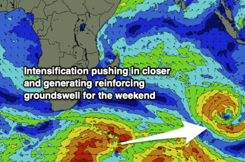
For Saturday evening and Sunday morning we have another reinforcing groundswell generated by an intensification at the back of that front building on an active sea state, that this time pushed in closer as it moved east. Sunday should see 6ft+ SW with the occasional 8ft from that source at Margs easing through the day, so flag that in as we will also have light easterlies.
Into early next week, we possibly have a large WSW groundswell this time produced at mid latitudes by a low moving east through the Indian, however again with tricky winds. Models are still diverging with the timing for this one, which could be Monday or Tuesday so we will provide an update on that later in the week.