Tricky outlook with solid west swells

Western Australian Forecast by Craig Brokensha (issued Wednesday May 28th)
Best Days: Sunday, selected spots Tuesday and possibly Wednesday
Features of the Forecast (tl;dr)
- Later increase in inconsistent W'ly groundswell today, peaking tomorrow with strong NE winds
- Poor Fri with strong N/NE tending N/NW winds
- Fresh W/NW-NW tending S/SW winds Sat
- Mod-large sized, inconsistent SW groundswell Sat, peaking PM, easing Sun
- Moderate E/NE tending variable winds Sun
- Smaller Mon with strong NE tending N/NE winds
- Large W'ly groundswell for later Mon, peaking Tue with strong NN/NE tending N winds
- Easing surf Wed with weaker N/NE tending S/SW winds
Recap
Monday’s large S’ly groundswell eased back through the afternoon and further yesterday morning with slow, clean 4-5ft sets on the South West magnets early, smaller through the day.
To the north the swell was tiny and conditions got more blustery through the day as winds shifted more north of east.
Today the surf is tiny with stronger NE winds.
This week and next (May 29 - Jun 6)
The coming days will be influenced by the wind rather than swell, with strong NE winds due tomorrow to a weakening mid-latitude low that's currently sitting west of us. Winds will shift more N/NE to N/NW on Friday as the low nears and then W/NW-NW on Saturday morning ahead of a S/SW change as it moves across us.
Swell wise, an inconsistent W’ly groundswell from the earlier stages of the low is expected later today, peaking tomorrow, though with the strong NE winds options will be limited. The metro regions should come in at 2ft to possibly 3ft with 4-6ft sets in the South West.
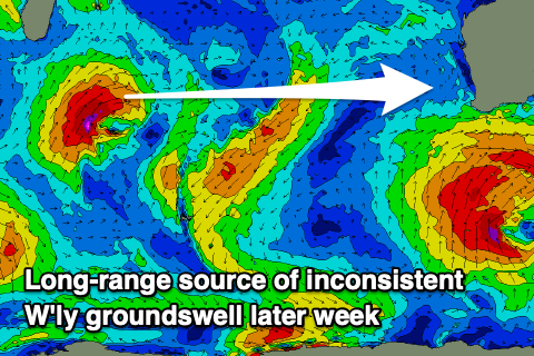
On Friday, some additional mid-period W’ly swell from the remnants of the low currently west of us is due but the deteriorating winds and conditions will leave little to no quality options.
As touched on in Monday’s notes, an inconsistent SW groundswell is due to fill in on Saturday, produced by a strong but distant polar low that formed south of South Africa earlier this week. A fetch of severe-gale to storm-force W-W/NW winds were generated in our far swell window, weakening on approach to the Heard Island region yesterday.

This should produce inconsistent 6ft to occasionally 8ft sets across Margaret River into Saturday afternoon but with those S/SW winds, with 2ft+ waves across Mandurah, 2ft in Perth.
Sunday looks much better as the swell eases back from 6ft+ in the South West and 2ft to the north under moderate E/NE tending variable winds.
Moving into next week, winds will strengthen from the NE tending N/NE through Monday as the weekend’s swell drops further, with a strong mid-latitude low forming west of us through the weekend expected to slowly move in through the week.
The low itself looks to generate a large W’ly groundswell for later Monday but more so Tuesday, with a slow moving fetch of gale to severe-gale W’ly winds due to form around its northern flank on the weekend.
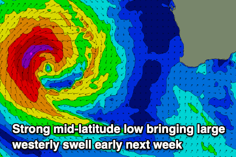
Unfortunately the slow movement of the low into us early next week will bring strong N/NE tending N winds on Tuesday when the peak in energy is due, shifting from N/NE to S/SW Wednesday once the low move across us. Depending on the timing we may see a period of variable winds Wednesday but we’ll have to look at this closer on Friday and then Monday next week.
Size wise the South West looks to come in at 8ft or so from the W/NW angle with 3-5ft waves in Mandurah, 3-4ft across Perth.
Longer term, in the wake of the low S/SE winds are expected along with a likely large SW groundswell later next week, but more on this Friday.