Make the most of today

Western Australian Forecast by Craig Brokensha (issued Monday May 26th)
Best Days: Today, selected south magnets in the South West tomorrow morning, possibly Saturday morning Perth/Mandurah
Features of the Forecast (tl;dr)
- Steadily easing S'ly groundswell tomorrow with strong E/NE tending slightly weaker NE winds
- Small to tiny Wed with strong NE winds
- Later increase in inconsistent W'ly groundswell Wed, peaking Thu with strong NE winds
- Poor Fri with strong N-N/NE tending N/NW winds
- Strong but easing W/NW tending W/SW winds Sat (possibly N/NE early Perth/Mandurah)
- Moderate + sized, inconsistent SW groundswell Sat, easing Sun
- Strong N/NE winds Sun
- Large W swell Tue with onshore winds
Recap
The weekend was a write-off across the South West while Perth and Mandurah saw morning offshore winds and clean conditions along with some decent size still in the mix Saturday from Friday.
Yesterday was then poor across the metro locations as strong SW winds kicked in.
Today we’ve got our large, new S’ly groundswell in the water with clean conditions across the South West and 8-10ft sets on the magnets, while to the north it’s much smaller and less consistent.

Large new south swell this morning
This week and weekend (May 27 - Jun 1)
The current S’ly groundswell generated by a strong, strengthening polar frontal system pushing up towards the south of the state over the weekend has peaked and from here on it’ll be a steady drop in size across all regions as the direction tweaks a bit more south again.
The South West magnets should still be 6ft early tomorrow, much smaller into the afternoon and spots not exposed to the south energy will be small to tiny.
Conditions will be tricky with strong E/NE breezes in the morning, easing a touch into the afternoon while shifting more NE.
Wednesday will then be a lay day with strong NE winds and no real decent size.
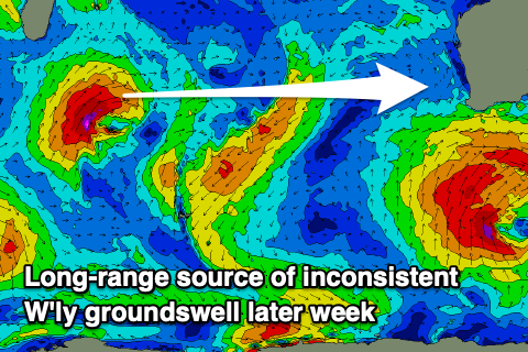
Later in the day Wednesday but more so Thursday, our long-range westerly swell is still on track, with a strong but distant low forming south-east of Madagascar, projecting a tight fetch of severe-gale towards us.
With the low being so north in location, the incoming energy will be very west, even W/NW across Margs and we should see Perth/Mandurah coming in at 2ft to possibly 3ft Thursday with 4-6ft waves in the South West.
Conditions will remain average and wind affected though with strong NE winds Thursday, shifting N/NE-N/NW on Friday as the swell eases and the remnants of the swell producing low moves in and towards us.
Some localised windswell will also be in the mix but options limited with those winds.
Strong W/NW tending weaker W/SW winds are due Saturday (possibly N/NE Perth/Mandurah) as the weakening low pushes across us, spoiling a new pulse of moderate + sized SW groundswell.

This groundswell was generated yesterday by a storm-force polar low that formed south of South Africa, in our far swell window and is now weakening west of the Heard Island region.
It’ll be another inconsistent number but the South West should see 6ft+ sets with 2ft waves in Mandurah and Perth.
There’ll be no letup in winds Sunday as they quickly strengthen from the N’th again ahead of a strong, deepening mid-latitude low to our west. This looks to generate some large W’ly swell early next week but with onshore winds as it slowly moves across us. More on this Wednesday.