Metro locations tomorrow, the South West Monday

Western Australian Forecast by Craig Brokensha (issued Friday May 23rd)
Best Days: Perth and Mandurah tomorrow morning, Monday all locations
Features of the Forecast (tl;dr)
- Slowly easing SW swell over the weekend with freshening SW tending stronger W/SW winds in the South West tomorrow (possibly variable early), light E/NE to the north in the AM
- Smaller Sun with strong SW winds, possibly S/SE early to the north
- Large S'ly groundswell Mon, easing, much smaller and fading Tue
- Mod-fresh E-E/NE winds in the South West Mon, E/SE to the north
- Fresh E/NE-NE winds Tue
- Moderate sized, inconsistent W'ly groundswell Thu with strong NE winds, easing and tending N/NE
- Easing groundswell Fri with strong NE winds
Recap
We saw the long–period SW groundswell from the ‘bombing’ low pulsing strongly into the mid-late afternoon on Wednesday with 12-15ft sets hitting the South West under variable winds.
Yesterday was then a write-off with the next swell generating system moving in bringing strong onshore winds and easing surf from 10-12ft in the South West while Mandurah and Perth saw early workable winds and good sized surf before the west wind kicked in.
Today we’ve got our large reinforcing swell with onshore winds across the South West, raw conditions in Mandurah with Perth offering the best of it under variable offshore winds and with 2-3ft sets.
This weekend and next week (May 24 - 30)
The weekend ahead will see gradually easing surf in the wake of the swell generating front passing through yesterday and today, with better conditions expected across the metro regions tomorrow while remaining onshore in the South West.
Freshening SW winds are due to strengthen from the W/SW tomorrow afternoon in the South West as a strong polar front projects up from the south towards the state, though Perth and Mandurah should see variable E/NE winds and cleaner conditions. There’s an outside chance of variable winds early around Margs but conditions will be quite raw and lumpy.
The swell will be on the downwards trend but Mandurah should still be 2-3ft with 2ft waves across Perth.
Come Sunday, strong SW tending S/SW then S winds are due as the frontal system clears east and high pressure moves in though the swell will be small to tiny across the metro regions and likely back to 2ft Mandurah 1-2ft Perth. There’s likely S/SE winds due early Sunday in metro regions but with a bit of lump.
Monday is the pick of the week next week as the frontal system linked to the weekend’s onshore winds brings a large pulse of S/SW groundswell that’s due to peak in the morning.
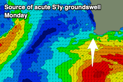
The polar front will project a great fetch of strong to gale-force S/SW winds up through our southern swell window over the coming days, with the south of the state expected to see XL surf Monday thanks to a severe-gale fetch around the core of the low aiming right into them.
The swell will be acute south for the South West but we should still see 10ft of swell across the south magnets with much smaller waves getting into other spots, very small inside sheltered coves.
Mandurah should see slow 2ft to occasionally 3ft sets on the south magnets, a slow 2ft across Perth. Winds will shift moderate to fresh E-E/NE across the South West Monday morning with E/SE breezes to the north, holding all day.
The swell will ease steadily through the day Monday with Tuesday coming in under half the size and more south with gusty E/NE tending NE winds favouring those south magnets in the South West.
Wednesday looks to come in at a low point while from Thursday into next weekend we should see some inconsistent W’ly groundswell filling in, generated by a strong mid-latitude low firing up to the south-east of Madagascar tomorrow.
The low will actually project far north in our western swell window, with a tight fetch of gale to severe-gale W/SW-SW winds due to generate a moderate sized W’ly groundswell that should arrive Thursday. The swell looks best aimed for Perth and Mandurah and further north with slow 2ft to possibly 3ft sets due, with Margs coming in around 4-6ft or so.
Strong NE winds will limit options on Thursday, shifting more N/NE during the day with Friday seeing even stronger NE winds as the swell eases.
These winds will actually be associated with the remnants of the swell producing low moving in slowly from the west while weakening, with W/NW-NW winds due in its wake next weekend. A good new SW groundswell for Saturday will be spoiled, but we’ll have a closer look at this on Monday. Have a great weekend!
Comments
Craig
How many days needed to finish wct event?1 if overlapping heats?
If so will Monday run
Monday will run but they might need a bit more time. Ending at 3ft Mainbreak Tuesday would be a fail, they might try tomorrow if winds are light enough but by the time they get underway the winds will kick in..
They should have run those extra heats when it was pumping on Wednesday afternoon!
That decision and the late start Wednesday may cost them.
As you said Craig, they've got a lot to get through on Monday to finish, looks like ending at 3ft Mainbreak Tuesday it is
Thanks Craig. Does Swellnet have any intel on why they didn't keep running on Wednesday?
Hi Craig, or WA locals, what’s main break like on acute southerly swell?
Shit to middling
Thanks - hopefully it’s a shitshow, will make up for the tour manager not getting them out there at dawn, on previous opportunities
Im thinking the lefts at Main Break would roll better and the right will be funky on a super south swell, Southside and Bombie pick up more swell and take some of the energy away from MB
JMD will put some spin on it