Best over the next two days

Western Australian Forecast by Craig Brokensha (issued Monday May 19th)
Best Days: Tomorrow, Wednesday, early Thursday Perth/Mandurah, Perth and Mandurah Friday and Saturday morning
Features of the Forecast (tl;dr)
- Large mid-period SW swell tomorrow AM, easing
- Light to moderate E/NE-NE tending variable winds tomorrow
- Reinforcing slightly smaller SW swell Wed AM, ahead of a new pulse of SW groundswell for the PM (possible late larger sets from long-period forerunners due Thursday)
- Moderate E/NE tending variable winds Wed
- Oversized long-period SW groundswell peaking Thu AM, easing during the day
- Strengthening NW tending W/NW winds with early N/NE winds to the north
- Large reinforcing SW swell Fri with strong S/SW winds, likely S/SE early to the north
- Easing surf over the weekend with increasing S/SW tending SW winds Sat (E/NE early Perth/Mandurah) and strong SW winds Sun
- Cleaner next week but smaller
Recap
Late last week’s large swell eased all weekend with clean conditions Saturday morning, average and wind affected through the afternoon, much smaller and with rapidly freshening N/NE winds yesterday.
Today we’ve got strong onshore winds and poor surf right across the state.
This week and weekend (May 20 - 25)
We’ve got an active week of surf ahead but it’ll be the coming days that will be the pick of it before onshore winds move in Thursday, spoiling an oversized, strong SW groundswell.
Looking at tomorrow and the current onshore flow is thanks to a strong mid-latitude low pushing in and under us, with a large mid-period SW swell due to peak tomorrow morning to the 8ft range in the South West, 2-3ft Mandurah and 2ft+ Perth, easing through the day.
Winds are due to rapidly improve as well, swinging light to moderate E/NE-NE tomorrow morning, and variable into the afternoon. The early will likely still be lumpy but we can expect improving conditions as the day progresses.
Wednesday morning looks a little smaller and back to 6ft+ across the South West, though into the afternoon a mix of new SW groundswell are due.
It’ll be a mix of normal SW groundswell and the forerunners of an oversized, long-period SW groundswell that’s due to peak Thursday morning.
The source is a ‘bombing’ low that’s currently formed east of the Heard Island region, with the low dropping well over 24hPa in a 24 hour period, bottoming out at 926hPa.
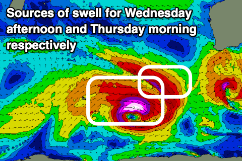
As the low ‘bombs’ we’re set to see pre-frontal severe-gale NW winds directly ahead of stronger storm to hurricane-force W’ly winds. The pre-frontal fetch will generate Wednesday afternoon’s increase in SW groundswell with building sets to 6-8ft likely across the South West, only 2ft in Mandurah. There's an outside chance for larger sets on dark when the forerunners of the larger swell Thurday arrives, so keep your eyes peeled.
Winds for Wednesday look great with a moderate E/NE offshore, tending variable into the afternoon.
Now, looking at Thursday, and the fetch of storm to hurricane-force W’ly winds will expand in scope but push further east and slowly towards our southern swell window through tomorrow, though there’ll be enough early swell production to generate an oversized SW groundswell for Thursday.
It looks like the South West will come in around 12ft with 3-4ft surf in Mandurah, 2-3ft across Perth.
Unfortunately the next approaching frontal system will bring strengthening NW tending W/NW winds on Thursday, with a window of lighter, early N/NE winds due across Perth and Mandurah, less likely across Margaret River.
Friday also looks like a write-off thanks to strong S/SW winds that will likely be S/SE for a period further north. Mandurah should still be 3ft or so, 2ft+ in Perth.
The weekend will see a general easing trend in swell (slowed in the South West by a reinforcing pulse of mid-period S/SW swell Saturday).
Winds look to linger out of the S/SW-SW across the South West Saturday with an outside chance of early S/SE winds, lighter E/NE to the north but small.
Sunday will be smaller and with strong SW winds, creating poor conditions.
Moving into next week and conditions will finally clean up across the South West into Monday but swell wise there’s not much to work with apart from some small, mid-period pulses.
More on this Wednesday.
Comments
Craig based on above when do you think contest will be run? Main break or the box
Both look decent to me but Wednesday is the inside word.
Great breakdown Craig. Cheers.