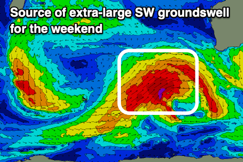
Oversized windy run for the South West

Western Australian Forecast by Craig Brokensha (issued Friday May 2nd)
Best Days: Perth and Mandurah Sunday morning, Monday morning and Tuesday morning, all locations Wednesday morning and Thursday morning
Features of the Forecast (tl;dr)
- XL SW groundswell building later tomorrow, peaking early Sun, then easing
- Strong W/SW tending SW winds Sat
- Strong W tending W/SW winds Sun (variable E/NE early Perth/Mandurah)
- Easing surf Mon with similar winds to Sun (fresh W/SW in the South West, easing)
- Large reinforcing SW groundswell for later Tue, peaking Wed
- S/SW winds Tue (E/SE-SE to the north)
- Fresh E/SE winds Wed ahead of sea breezes
- Easing surf Thu with early E/NE winds
Recap
There was a window of clean conditions early yesterday across the South West with 4-5ft of swell before the winds really picked up and wrote-off the surf for the rest of the day.
Today is a lay day across all locations with a building windswell and nowhere to hide from the wind.
This weekend and next week (May 3 - 9)
The current strengthening winds are thanks to a strong polar frontal progression pushing up towards us, with it due to clip the state tomorrow, bringing strong W/SW tending SW winds.
This will also bring building levels of windswell and mid-period energy ahead of the groundswell later in the day, peaking Sunday morning.
As talked about all week, a great fetch of severe-gale to storm-force W/SW tending SW winds have been projected towards us, generating an extra-large SW groundswell that should come in at 12-15ft across the South West with 4-5ft sets in Mandurah and 3-4ft waves across Perth.
The size will likely be seen on dark in the South West tomorrow but more so Sunday morning further north with strong W’ly tending W/SW winds.
Perth and Mandurah are due to see early variable winds Sunday likely out of the E/NE, with easing surf Monday under similar winds. The South West will be onshore but the W/SW breeze looks only fresh, easing through the day.
Margaret River will still be 8-10ft with 3ft waves in Mandurah and 2ft to possibly 3ft sets across Perth under E/SE-SE offshores north of Margs, with lingering onshore S/SW breezes due in the South West.

A large reinforcing SW groundswell is due later Tuesday/Wednesday thanks to a secondary frontal progression projecting towards us on the backside of the original progression through Sunday/Monday with 8ft to occasionally 10ft waves due in the South West with 2-3ft waves in Mandurah and 2ft+ waves across Perth.
Winds look to remain onshore from the S/SW across the South West Tuesday with offshores to the north, best Wednesday in the South West as winds finally swing E/SE.
Make the most of this day as the swell will fade into the end of the week with E/NE breezes likely Thursday, possibly onshore Friday.
More on this Monday, have a great weekend!